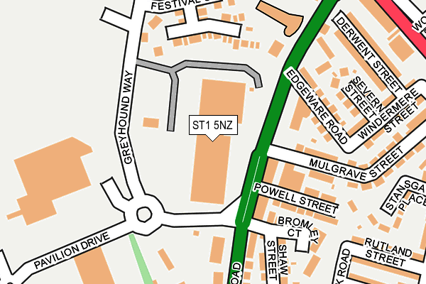
ST1 5NZ is located in the Etruria & Hanley electoral ward, within the unitary authority of Stoke-on-Trent and the English Parliamentary constituency of Stoke-on-Trent North. The Sub Integrated Care Board (ICB) Location is NHS Staffordshire and Stoke-on-Trent ICB - 05W and the police force is Staffordshire. This postcode has been in use since December 1996.


GetTheData
Source: OS OpenMap – Local (Ordnance Survey)
Source: OS VectorMap District (Ordnance Survey)
Licence: Open Government Licence (requires attribution)
| Easting | 387416 |
| Northing | 348298 |
| Latitude | 53.031814 |
| Longitude | -2.189095 |
GetTheData
Source: Open Postcode Geo
Licence: Open Government Licence
| Country | England |
| Postcode District | ST1 |
| ➜ ST1 open data dashboard ➜ See where ST1 is on a map ➜ Where is Stoke-on-Trent? | |
GetTheData
Source: Land Registry Price Paid Data
Licence: Open Government Licence
Elevation or altitude of ST1 5NZ as distance above sea level:
| Metres | Feet | |
|---|---|---|
| Elevation | 150m | 492ft |
Elevation is measured from the approximate centre of the postcode, to the nearest point on an OS contour line from OS Terrain 50, which has contour spacing of ten vertical metres.
➜ How high above sea level am I? Find the elevation of your current position using your device's GPS.
GetTheData
Source: Open Postcode Elevation
Licence: Open Government Licence
| Ward | Etruria & Hanley |
| Constituency | Stoke-on-trent North |
GetTheData
Source: ONS Postcode Database
Licence: Open Government Licence
| January 2024 | Other theft | On or near Petrol Station | 368m |
| January 2024 | Shoplifting | On or near Petrol Station | 368m |
| January 2024 | Anti-social behaviour | On or near Ridgehouse Drive | 459m |
| ➜ Get more crime data in our Crime section | |||
GetTheData
Source: data.police.uk
Licence: Open Government Licence
| Morrisons Supermarket (Pavilion Drive) | Festival Park | 295m |
| Morrisons Supermarket (Pavilion Drive) | Festival Park | 305m |
| Cobridge Lights (Waterloo Road) | Cobridge | 311m |
| Cobridge Lights (Waterloo Road) | Cobridge | 322m |
| Stadium Court (Greyhound Way) | Festival Park | 336m |
| Longport Station | 2.1km |
| Stoke-on-Trent Station | 2.7km |
| Longton Station | 5.8km |
GetTheData
Source: NaPTAN
Licence: Open Government Licence
GetTheData
Source: ONS Postcode Database
Licence: Open Government Licence


➜ Get more ratings from the Food Standards Agency
GetTheData
Source: Food Standards Agency
Licence: FSA terms & conditions
| Last Collection | |||
|---|---|---|---|
| Location | Mon-Fri | Sat | Distance |
| Windermere Street | 17:45 | 09:00 | 318m |
| Cobridge Park | 18:15 | 11:00 | 599m |
| Union Street | 18:00 | 10:30 | 726m |
GetTheData
Source: Dracos
Licence: Creative Commons Attribution-ShareAlike
| Facility | Distance |
|---|---|
| M Club Spa And Fitness (Hanley) Festival Heights Retail Park, Greyhound Way, Stoke-on-trent Studio, Swimming Pool, Health and Fitness Gym | 59m |
| Burslem Cc Greyhound Way, Stoke-on-trent Grass Pitches | 302m |
| Forest Park Primary School Woodall Street, Stoke-on-trent Grass Pitches | 392m |
GetTheData
Source: Active Places
Licence: Open Government Licence
| School | Phase of Education | Distance |
|---|---|---|
| Forest Park Primary School Woodall Street, Hanley, Stoke-on-Trent, ST1 5ED | Primary | 403m |
| St Peter's Catholic Academy Waterloo Road, Cobridge, Stoke-on-Trent, ST6 3HL | Primary | 454m |
| Phoenix U16 Independent School Unit E, Metro Business Park, Clough Street, Stoke on Trent, ST1 4AF | Not applicable | 951m |
GetTheData
Source: Edubase
Licence: Open Government Licence
The below table lists the International Territorial Level (ITL) codes (formerly Nomenclature of Territorial Units for Statistics (NUTS) codes) and Local Administrative Units (LAU) codes for ST1 5NZ:
| ITL 1 Code | Name |
|---|---|
| TLG | West Midlands (England) |
| ITL 2 Code | Name |
| TLG2 | Shropshire and Staffordshire |
| ITL 3 Code | Name |
| TLG23 | Stoke-on-Trent |
| LAU 1 Code | Name |
| E06000021 | Stoke-on-Trent |
GetTheData
Source: ONS Postcode Directory
Licence: Open Government Licence
The below table lists the Census Output Area (OA), Lower Layer Super Output Area (LSOA), and Middle Layer Super Output Area (MSOA) for ST1 5NZ:
| Code | Name | |
|---|---|---|
| OA | E00071973 | |
| LSOA | E01014254 | Stoke-on-Trent 011C |
| MSOA | E02002961 | Stoke-on-Trent 011 |
GetTheData
Source: ONS Postcode Directory
Licence: Open Government Licence
| ST1 5JL | Cobridge Road | 139m |
| ST1 5JS | Mulgrave Street | 150m |
| ST1 5JP | Cobridge Road | 159m |
| ST1 5JT | Edgeware Street | 170m |
| ST1 5JR | Powell Street | 177m |
| ST6 3LG | Festival Close | 181m |
| ST1 5EW | Severn Street | 193m |
| ST1 5JX | Cobridge Road | 208m |
| ST1 5JN | Shaw Street | 219m |
| ST1 5EN | Derwent Street | 235m |
GetTheData
Source: Open Postcode Geo; Land Registry Price Paid Data
Licence: Open Government Licence