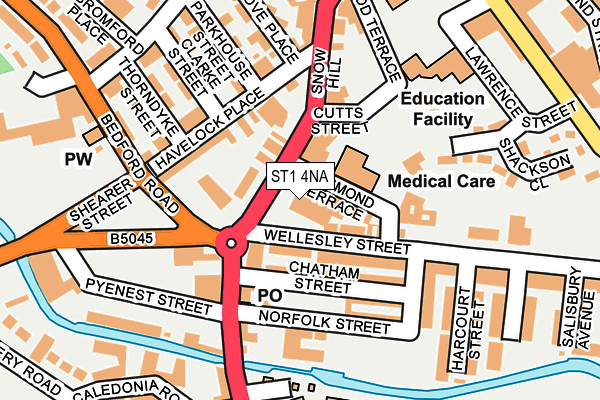
ST1 4NA is located in the Hanley Park, Joiner's Square & Shelton electoral ward, within the unitary authority of Stoke-on-Trent and the English Parliamentary constituency of Stoke-on-Trent Central. The Sub Integrated Care Board (ICB) Location is NHS Staffordshire and Stoke-on-Trent ICB - 05W and the police force is Staffordshire. This postcode has been in use since January 1980.


GetTheData
Source: OS OpenMap – Local (Ordnance Survey)
Source: OS VectorMap District (Ordnance Survey)
Licence: Open Government Licence (requires attribution)
| Easting | 387789 |
| Northing | 346648 |
| Latitude | 53.017008 |
| Longitude | -2.183469 |
GetTheData
Source: Open Postcode Geo
Licence: Open Government Licence
| Country | England |
| Postcode District | ST1 |
| ➜ ST1 open data dashboard ➜ See where ST1 is on a map ➜ Where is Stoke-on-Trent? | |
GetTheData
Source: Land Registry Price Paid Data
Licence: Open Government Licence
Elevation or altitude of ST1 4NA as distance above sea level:
| Metres | Feet | |
|---|---|---|
| Elevation | 140m | 459ft |
Elevation is measured from the approximate centre of the postcode, to the nearest point on an OS contour line from OS Terrain 50, which has contour spacing of ten vertical metres.
➜ How high above sea level am I? Find the elevation of your current position using your device's GPS.
GetTheData
Source: Open Postcode Elevation
Licence: Open Government Licence
| Ward | Hanley Park, Joiner's Square & Shelton |
| Constituency | Stoke-on-trent Central |
GetTheData
Source: ONS Postcode Database
Licence: Open Government Licence
| January 2024 | Anti-social behaviour | On or near Howard Place | 133m |
| January 2024 | Violence and sexual offences | On or near Howard Place | 133m |
| January 2024 | Violence and sexual offences | On or near Howard Place | 133m |
| ➜ Get more crime data in our Crime section | |||
GetTheData
Source: data.police.uk
Licence: Open Government Licence
| Howard Place (Snow Hill) | Shelton | 44m |
| Howard Place (Snow Hill) | Shelton | 68m |
| Havelock Place (Snow Hill) | Shelton | 200m |
| Shearer Street | Shelton | 216m |
| Pyenest Street (Shelton New Road) | Shelton | 218m |
| Stoke-on-Trent Station | 1km |
| Longport Station | 3.5km |
| Longton Station | 4.3km |
GetTheData
Source: NaPTAN
Licence: Open Government Licence
GetTheData
Source: ONS Postcode Database
Licence: Open Government Licence


➜ Get more ratings from the Food Standards Agency
GetTheData
Source: Food Standards Agency
Licence: FSA terms & conditions
| Last Collection | |||
|---|---|---|---|
| Location | Mon-Fri | Sat | Distance |
| Howard Place | 17:30 | 11:15 | 134m |
| Havelock Place | 17:30 | 11:00 | 140m |
| Victoria Square | 416m | ||
GetTheData
Source: Dracos
Licence: Creative Commons Attribution-ShareAlike
| Facility | Distance |
|---|---|
| Stoke On Trent College Sports Academy Stoke Road, Stoke-on-trent Health and Fitness Gym, Sports Hall, Studio | 248m |
| Stoke On Trent College (Cauldon Campus) (Closed) Stoke Road, Stoke-on-trent Health and Fitness Gym, Sports Hall | 266m |
| Shelton Pool (Closed) Simon Place, Stoke-on-trent Swimming Pool | 301m |
GetTheData
Source: Active Places
Licence: Open Government Licence
| School | Phase of Education | Distance |
|---|---|---|
| PEAK EDUCATION - STOKE 60 SNOWHILL, SHELTON, STOKE ON TRENT, ST1 4LY | Not applicable | 100m |
| St Mark's CofE Primary School Wood Terrace, Shelton, Stoke-on-Trent, ST1 4LR | Primary | 185m |
| Stoke-on-Trent College Cauldon Campus, Stoke Road, Shelton, Stoke-on-Trent, ST4 2DG | 16 plus | 266m |
GetTheData
Source: Edubase
Licence: Open Government Licence
The below table lists the International Territorial Level (ITL) codes (formerly Nomenclature of Territorial Units for Statistics (NUTS) codes) and Local Administrative Units (LAU) codes for ST1 4NA:
| ITL 1 Code | Name |
|---|---|
| TLG | West Midlands (England) |
| ITL 2 Code | Name |
| TLG2 | Shropshire and Staffordshire |
| ITL 3 Code | Name |
| TLG23 | Stoke-on-Trent |
| LAU 1 Code | Name |
| E06000021 | Stoke-on-Trent |
GetTheData
Source: ONS Postcode Directory
Licence: Open Government Licence
The below table lists the Census Output Area (OA), Lower Layer Super Output Area (LSOA), and Middle Layer Super Output Area (MSOA) for ST1 4NA:
| Code | Name | |
|---|---|---|
| OA | E00072134 | |
| LSOA | E01014286 | Stoke-on-Trent 015C |
| MSOA | E02002965 | Stoke-on-Trent 015 |
GetTheData
Source: ONS Postcode Directory
Licence: Open Government Licence
| ST1 4ND | Richmond Terrace | 59m |
| ST1 4NF | Wellesley Street | 65m |
| ST1 4LY | Snow Hill | 66m |
| ST1 4NY | Chatham Street | 85m |
| ST1 4NW | Wellesley Street | 96m |
| ST1 4NN | Howard Place | 100m |
| ST1 4PS | Havelock Place | 107m |
| ST1 4PR | Havelock Place | 128m |
| ST1 4LU | Snow Hill | 138m |
| ST1 4NJ | Howard Place | 149m |
GetTheData
Source: Open Postcode Geo; Land Registry Price Paid Data
Licence: Open Government Licence