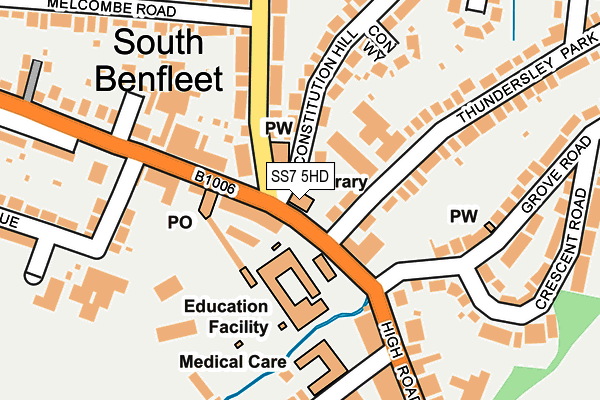
SS7 5HD is located in the St Mary's electoral ward, within the local authority district of Castle Point and the English Parliamentary constituency of Castle Point. The Sub Integrated Care Board (ICB) Location is NHS Mid and South Essex ICB - 99F and the police force is Essex. This postcode has been in use since January 1980.


GetTheData
Source: OS OpenMap – Local (Ordnance Survey)
Source: OS VectorMap District (Ordnance Survey)
Licence: Open Government Licence (requires attribution)
| Easting | 577592 |
| Northing | 186971 |
| Latitude | 51.553671 |
| Longitude | 0.560226 |
GetTheData
Source: Open Postcode Geo
Licence: Open Government Licence
| Country | England |
| Postcode District | SS7 |
| ➜ SS7 open data dashboard ➜ See where SS7 is on a map ➜ Where is South Benfleet? | |
GetTheData
Source: Land Registry Price Paid Data
Licence: Open Government Licence
Elevation or altitude of SS7 5HD as distance above sea level:
| Metres | Feet | |
|---|---|---|
| Elevation | 10m | 33ft |
Elevation is measured from the approximate centre of the postcode, to the nearest point on an OS contour line from OS Terrain 50, which has contour spacing of ten vertical metres.
➜ How high above sea level am I? Find the elevation of your current position using your device's GPS.
GetTheData
Source: Open Postcode Elevation
Licence: Open Government Licence
| Ward | St Mary's |
| Constituency | Castle Point |
GetTheData
Source: ONS Postcode Database
Licence: Open Government Licence
| January 2024 | Violence and sexual offences | On or near Parking Area | 316m |
| December 2023 | Possession of weapons | On or near Parking Area | 316m |
| December 2023 | Possession of weapons | On or near Parking Area | 316m |
| ➜ Get more crime data in our Crime section | |||
GetTheData
Source: data.police.uk
Licence: Open Government Licence
| Kents Hill Road (High Road) | South Benfleet | 22m |
| High Road (Kents Hill Road) | South Benfleet | 89m |
| Kents Hill Road (High Road) | South Benfleet | 93m |
| Boyce Green (High Road) | South Benfleet | 244m |
| Boyce Green (High Road) | South Benfleet | 279m |
| Benfleet Station | 1.1km |
| Pitsea Station | 3.8km |
| Rayleigh Station | 4.8km |
GetTheData
Source: NaPTAN
Licence: Open Government Licence
GetTheData
Source: ONS Postcode Database
Licence: Open Government Licence


➜ Get more ratings from the Food Standards Agency
GetTheData
Source: Food Standards Agency
Licence: FSA terms & conditions
| Last Collection | |||
|---|---|---|---|
| Location | Mon-Fri | Sat | Distance |
| Benfleet Station | 17:00 | 12:30 | 1,087m |
| Woodlands | 17:15 | 12:30 | 1,379m |
| Southwold Crescent | 17:00 | 12:00 | 1,427m |
GetTheData
Source: Dracos
Licence: Creative Commons Attribution-ShareAlike
| Facility | Distance |
|---|---|
| South Benfleet Primary School High Road, Benfleet Swimming Pool, Grass Pitches | 67m |
| Bodycare Personal Fitness Club High Road, Benfleet Health and Fitness Gym, Studio | 90m |
| Richmond Hall High Road, Benfleet Sports Hall | 158m |
GetTheData
Source: Active Places
Licence: Open Government Licence
| School | Phase of Education | Distance |
|---|---|---|
| South Benfleet Primary School High Road, South Benfleet, Benfleet, SS7 5HA | Primary | 67m |
| Kents Hill Junior School Kents Hill Road, Benfleet, SS7 5PS | Primary | 848m |
| Kents Hill Infant Academy Kents Hill Road, Benfleet, SS7 5PS | Primary | 848m |
GetTheData
Source: Edubase
Licence: Open Government Licence
The below table lists the International Territorial Level (ITL) codes (formerly Nomenclature of Territorial Units for Statistics (NUTS) codes) and Local Administrative Units (LAU) codes for SS7 5HD:
| ITL 1 Code | Name |
|---|---|
| TLH | East |
| ITL 2 Code | Name |
| TLH3 | Essex |
| ITL 3 Code | Name |
| TLH37 | Essex Thames Gateway |
| LAU 1 Code | Name |
| E07000069 | Castle Point |
GetTheData
Source: ONS Postcode Directory
Licence: Open Government Licence
The below table lists the Census Output Area (OA), Lower Layer Super Output Area (LSOA), and Middle Layer Super Output Area (MSOA) for SS7 5HD:
| Code | Name | |
|---|---|---|
| OA | E00109339 | |
| LSOA | E01021524 | Castle Point 007E |
| MSOA | E02004479 | Castle Point 007 |
GetTheData
Source: ONS Postcode Directory
Licence: Open Government Licence
| SS7 5HA | High Road | 81m |
| SS7 5LA | High Road | 96m |
| SS7 5HB | High Road | 128m |
| SS7 5HZ | High Road | 146m |
| SS7 1ED | Constitution Hill | 166m |
| SS7 1EF | Con Way | 168m |
| SS7 5PN | Kents Hill Road | 169m |
| SS7 1EB | Constitution Hill | 191m |
| SS7 5PL | Kents Hill Road | 193m |
| SS7 5JB | Brook Road | 208m |
GetTheData
Source: Open Postcode Geo; Land Registry Price Paid Data
Licence: Open Government Licence