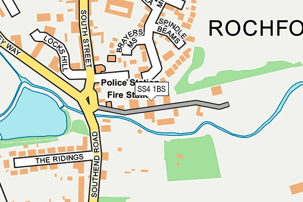
SS4 1BS lies on Riverside Industrial Estate in Rochford. SS4 1BS is located in the Roche South electoral ward, within the local authority district of Rochford and the English Parliamentary constituency of Rochford and Southend East. The Sub Integrated Care Board (ICB) Location is NHS Mid and South Essex ICB - 99F and the police force is Essex. This postcode has been in use since February 1990.


GetTheData
Source: OS OpenMap – Local (Ordnance Survey)
Source: OS VectorMap District (Ordnance Survey)
Licence: Open Government Licence (requires attribution)
| Easting | 587795 |
| Northing | 190255 |
| Latitude | 51.579864 |
| Longitude | 0.708977 |
GetTheData
Source: Open Postcode Geo
Licence: Open Government Licence
| Street | Riverside Industrial Estate |
| Town/City | Rochford |
| Country | England |
| Postcode District | SS4 |
➜ See where SS4 is on a map ➜ Where is Rochford? | |
GetTheData
Source: Land Registry Price Paid Data
Licence: Open Government Licence
Elevation or altitude of SS4 1BS as distance above sea level:
| Metres | Feet | |
|---|---|---|
| Elevation | 10m | 33ft |
Elevation is measured from the approximate centre of the postcode, to the nearest point on an OS contour line from OS Terrain 50, which has contour spacing of ten vertical metres.
➜ How high above sea level am I? Find the elevation of your current position using your device's GPS.
GetTheData
Source: Open Postcode Elevation
Licence: Open Government Licence
| Ward | Roche South |
| Constituency | Rochford And Southend East |
GetTheData
Source: ONS Postcode Database
Licence: Open Government Licence
STEPHENSONS OF ESSEX, RIVERSIDE INDUSTRIAL ESTATE, ROCHFORD, SS4 1BS 2006 15 DEC £320,000 |
GetTheData
Source: HM Land Registry Price Paid Data
Licence: Contains HM Land Registry data © Crown copyright and database right 2025. This data is licensed under the Open Government Licence v3.0.
| South Street (Southend Road) | Rochford | 136m |
| South Street (Southend Road) | Rochford | 165m |
| The Square (West Street) | Rochford | 307m |
| East Street | Rochford | 307m |
| North Street | Rochford | 382m |
| Rochford Station | 0.5km |
| Southend Airport Station | 1.3km |
| Prittlewell Station | 3.2km |
GetTheData
Source: NaPTAN
Licence: Open Government Licence
GetTheData
Source: ONS Postcode Database
Licence: Open Government Licence


➜ Get more ratings from the Food Standards Agency
GetTheData
Source: Food Standards Agency
Licence: FSA terms & conditions
| Last Collection | |||
|---|---|---|---|
| Location | Mon-Fri | Sat | Distance |
| 14 West Street P.o. | 17:30 | 12:00 | 355m |
| North Street Post Office | 17:30 | 12:00 | 357m |
| Malting Villas | 17:30 | 12:30 | 527m |
GetTheData
Source: Dracos
Licence: Creative Commons Attribution-ShareAlike
| Risk of SS4 1BS flooding from rivers and sea | Low |
| ➜ SS4 1BS flood map | |
GetTheData
Source: Open Flood Risk by Postcode
Licence: Open Government Licence
The below table lists the International Territorial Level (ITL) codes (formerly Nomenclature of Territorial Units for Statistics (NUTS) codes) and Local Administrative Units (LAU) codes for SS4 1BS:
| ITL 1 Code | Name |
|---|---|
| TLH | East |
| ITL 2 Code | Name |
| TLH3 | Essex |
| ITL 3 Code | Name |
| TLH37 | Essex Thames Gateway |
| LAU 1 Code | Name |
| E07000075 | Rochford |
GetTheData
Source: ONS Postcode Directory
Licence: Open Government Licence
The below table lists the Census Output Area (OA), Lower Layer Super Output Area (LSOA), and Middle Layer Super Output Area (MSOA) for SS4 1BS:
| Code | Name | |
|---|---|---|
| OA | E00111499 | |
| LSOA | E01021952 | Rochford 007C |
| MSOA | E02004569 | Rochford 007 |
GetTheData
Source: ONS Postcode Directory
Licence: Open Government Licence
| SS4 1XF | Brayers Mews | 115m |
| SS4 1EF | Millview Meadows | 116m |
| SS4 1EH | Spindle Beams | 119m |
| SS4 1BL | South Street | 142m |
| SS4 1HA | Southend Road | 144m |
| SS4 1HG | Tinkers Lane | 148m |
| SS4 1HB | Southend Road | 170m |
| SS4 1DJ | The Trunnions | 212m |
| SS4 1BQ | South Street | 223m |
| SS4 1HE | Southend Road | 233m |
GetTheData
Source: Open Postcode Geo; Land Registry Price Paid Data
Licence: Open Government Licence