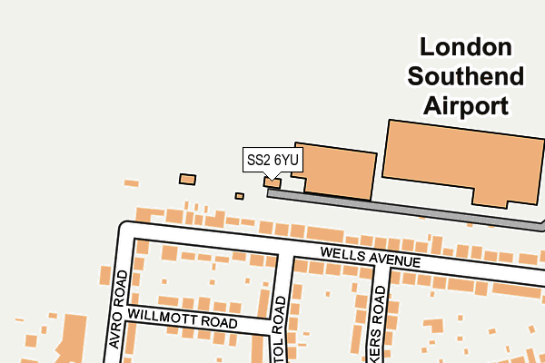
SS2 6YU is located in the Roche South electoral ward, within the local authority district of Rochford and the English Parliamentary constituency of Rochford and Southend East. The Sub Integrated Care Board (ICB) Location is NHS Mid and South Essex ICB - 99F and the police force is Essex. This postcode has been in use since March 1982.


GetTheData
Source: OS OpenMap – Local (Ordnance Survey)
Source: OS VectorMap District (Ordnance Survey)
Licence: Open Government Licence (requires attribution)
| Easting | 586836 |
| Northing | 188895 |
| Latitude | 51.567973 |
| Longitude | 0.694459 |
GetTheData
Source: Open Postcode Geo
Licence: Open Government Licence
| Country | England |
| Postcode District | SS2 |
| ➜ SS2 open data dashboard ➜ See where SS2 is on a map | |
GetTheData
Source: Land Registry Price Paid Data
Licence: Open Government Licence
Elevation or altitude of SS2 6YU as distance above sea level:
| Metres | Feet | |
|---|---|---|
| Elevation | 10m | 33ft |
Elevation is measured from the approximate centre of the postcode, to the nearest point on an OS contour line from OS Terrain 50, which has contour spacing of ten vertical metres.
➜ How high above sea level am I? Find the elevation of your current position using your device's GPS.
GetTheData
Source: Open Postcode Elevation
Licence: Open Government Licence
| Ward | Roche South |
| Constituency | Rochford And Southend East |
GetTheData
Source: ONS Postcode Database
Licence: Open Government Licence
| June 2022 | Vehicle crime | On or near Eastwoodbury Close | 400m |
| June 2022 | Violence and sexual offences | On or near Nightingale Close | 434m |
| June 2022 | Violence and sexual offences | On or near Nightingale Close | 434m |
| ➜ Get more crime data in our Crime section | |||
GetTheData
Source: data.police.uk
Licence: Open Government Licence
| Vickers Road (Eastwoodbury Lane) | Prittlewell | 251m |
| Vickers Road (Eastwoodbury Lane) | Prittlewell | 266m |
| Avro Road (Eastwoodbury Lane) | Prittlewell | 313m |
| Avro Road (Eastwoodbury Lane) | Prittlewell | 343m |
| Holiday Inn Southend Airport (Eastwoodbury Crescent) | Prittlewell | 401m |
| Southend Airport Station | 0.7km |
| Rochford Station | 1.6km |
| Prittlewell Station | 2.2km |
GetTheData
Source: NaPTAN
Licence: Open Government Licence
GetTheData
Source: ONS Postcode Database
Licence: Open Government Licence


➜ Get more ratings from the Food Standards Agency
GetTheData
Source: Food Standards Agency
Licence: FSA terms & conditions
| Last Collection | |||
|---|---|---|---|
| Location | Mon-Fri | Sat | Distance |
| Eastwoodbury Post Office | 17:30 | 11:30 | 320m |
| Avro Road | 17:30 | 11:30 | 357m |
| Feeches Road | 17:30 | 11:30 | 597m |
GetTheData
Source: Dracos
Licence: Creative Commons Attribution-ShareAlike
| Facility | Distance |
|---|---|
| Flights Leisure (Closed) Aviation Way, Southend Airport, Southend-on-sea Studio, Health and Fitness Gym, Squash Courts | 837m |
| Warners Bridge Park Agp Sumpters Way, Southend-on-sea Artificial Grass Pitch | 888m |
| Prince Avenue Academy And Nursery Hornby Avenue, Westcliff-on-sea Grass Pitches | 890m |
GetTheData
Source: Active Places
Licence: Open Government Licence
| School | Phase of Education | Distance |
|---|---|---|
| Prince Avenue Academy and Nursery Hornby Avenue, Westcliff-on-Sea, SS0 0LG | Primary | 890m |
| Earls Hall Primary School Carlton Avenue, Westcliff-on-Sea, SS0 0QN | Primary | 1.3km |
| Southend High School for Boys Prittlewell Chase, Southend-on-Sea, SS0 0RG | Secondary | 1.6km |
GetTheData
Source: Edubase
Licence: Open Government Licence
The below table lists the International Territorial Level (ITL) codes (formerly Nomenclature of Territorial Units for Statistics (NUTS) codes) and Local Administrative Units (LAU) codes for SS2 6YU:
| ITL 1 Code | Name |
|---|---|
| TLH | East |
| ITL 2 Code | Name |
| TLH3 | Essex |
| ITL 3 Code | Name |
| TLH37 | Essex Thames Gateway |
| LAU 1 Code | Name |
| E07000075 | Rochford |
GetTheData
Source: ONS Postcode Directory
Licence: Open Government Licence
The below table lists the Census Output Area (OA), Lower Layer Super Output Area (LSOA), and Middle Layer Super Output Area (MSOA) for SS2 6YU:
| Code | Name | |
|---|---|---|
| OA | E00111502 | |
| LSOA | E01021954 | Rochford 007D |
| MSOA | E02004569 | Rochford 007 |
GetTheData
Source: ONS Postcode Directory
Licence: Open Government Licence
| SS2 6XN | Wells Avenue | 139m |
| SS2 6XJ | Wells Avenue | 161m |
| SS2 6XL | Wells Avenue | 172m |
| SS2 6XD | Vickers Road | 177m |
| SS2 6XA | Bristol Road | 178m |
| SS2 6XB | Willmott Road | 217m |
| SS2 6XE | Eastwoodbury Lane | 265m |
| SS2 6UY | Eastwoodbury Lane | 268m |
| SS2 6UX | Avro Road | 270m |
| SS2 6XF | Eastwoodbury Lane | 293m |
GetTheData
Source: Open Postcode Geo; Land Registry Price Paid Data
Licence: Open Government Licence