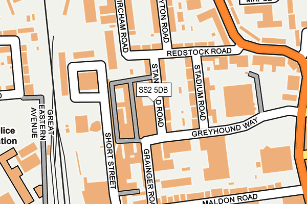
SS2 5DB is located in the Victoria electoral ward, within the unitary authority of Southend-on-Sea and the English Parliamentary constituency of Rochford and Southend East. The Sub Integrated Care Board (ICB) Location is NHS Mid and South Essex ICB - 99G and the police force is Essex. This postcode has been in use since January 1980.


GetTheData
Source: OS OpenMap – Local (Ordnance Survey)
Source: OS VectorMap District (Ordnance Survey)
Licence: Open Government Licence (requires attribution)
| Easting | 588286 |
| Northing | 186450 |
| Latitude | 51.545527 |
| Longitude | 0.714019 |
GetTheData
Source: Open Postcode Geo
Licence: Open Government Licence
| Country | England |
| Postcode District | SS2 |
| ➜ SS2 open data dashboard ➜ See where SS2 is on a map ➜ Where is Southend-on-Sea? | |
GetTheData
Source: Land Registry Price Paid Data
Licence: Open Government Licence
Elevation or altitude of SS2 5DB as distance above sea level:
| Metres | Feet | |
|---|---|---|
| Elevation | 30m | 98ft |
Elevation is measured from the approximate centre of the postcode, to the nearest point on an OS contour line from OS Terrain 50, which has contour spacing of ten vertical metres.
➜ How high above sea level am I? Find the elevation of your current position using your device's GPS.
GetTheData
Source: Open Postcode Elevation
Licence: Open Government Licence
| Ward | Victoria |
| Constituency | Rochford And Southend East |
GetTheData
Source: ONS Postcode Database
Licence: Open Government Licence
| January 2024 | Criminal damage and arson | On or near Milton Street | 287m |
| January 2024 | Criminal damage and arson | On or near Milton Street | 287m |
| January 2024 | Violence and sexual offences | On or near Byron Avenue | 461m |
| ➜ Get more crime data in our Crime section | |||
GetTheData
Source: data.police.uk
Licence: Open Government Licence
| Vale Avenue (Sutton Road) | Southchurch | 256m |
| Stadium Greyhound Way (Sutton Road) | Southchurch | 291m |
| Stadium Greyhound Way (Sutton Road) | Southchurch | 295m |
| Vale Avenue (Sutton Road) | Southchurch | 303m |
| Central Avenue West (Central Avenue) | Southchurch | 334m |
| Southend Victoria Station | 0.5km |
| Prittlewell Station | 0.6km |
| Southend Central Station | 1km |
GetTheData
Source: NaPTAN
Licence: Open Government Licence
GetTheData
Source: ONS Postcode Database
Licence: Open Government Licence

➜ Get more ratings from the Food Standards Agency
GetTheData
Source: Food Standards Agency
Licence: FSA terms & conditions
| Last Collection | |||
|---|---|---|---|
| Location | Mon-Fri | Sat | Distance |
| Bircham Road | 18:30 | 11:30 | 135m |
| Browning Avenue | 18:30 | 11:30 | 268m |
| Civic Centre | 17:30 | 11:30 | 383m |
GetTheData
Source: Dracos
Licence: Creative Commons Attribution-ShareAlike
| Facility | Distance |
|---|---|
| Sas Gym Grainger Road, Southend-on-sea Health and Fitness Gym | 121m |
| South East Essex College Of Arts And Technology (Closed) Carnarvon Road, Southend-on-sea Grass Pitches | 310m |
| Southend-on-sea Bowls Club Tunbridge Road, Southend-on-sea Indoor Bowls | 435m |
GetTheData
Source: Active Places
Licence: Open Government Licence
| School | Phase of Education | Distance |
|---|---|---|
| Bournemouth Park Academy Bournemouth Park Road, Southend-on-Sea, SS2 5JN | Primary | 514m |
| Southend YMCA Community School The Ticket House, 110 East Street, Prittlewell, Southend-on-Sea, SS2 6LH | Not applicable | 554m |
| St Mary's, Prittlewell, CofE Primary School Boston Avenue, Southend-on-Sea, SS2 6JH | Primary | 674m |
GetTheData
Source: Edubase
Licence: Open Government Licence
The below table lists the International Territorial Level (ITL) codes (formerly Nomenclature of Territorial Units for Statistics (NUTS) codes) and Local Administrative Units (LAU) codes for SS2 5DB:
| ITL 1 Code | Name |
|---|---|
| TLH | East |
| ITL 2 Code | Name |
| TLH3 | Essex |
| ITL 3 Code | Name |
| TLH31 | Southend-on-Sea |
| LAU 1 Code | Name |
| E06000033 | Southend-on-Sea |
GetTheData
Source: ONS Postcode Directory
Licence: Open Government Licence
The below table lists the Census Output Area (OA), Lower Layer Super Output Area (LSOA), and Middle Layer Super Output Area (MSOA) for SS2 5DB:
| Code | Name | |
|---|---|---|
| OA | E00080395 | |
| LSOA | E01015898 | Southend-on-Sea 010D |
| MSOA | E02003288 | Southend-on-Sea 010 |
GetTheData
Source: ONS Postcode Directory
Licence: Open Government Licence
| SS2 5DQ | Stanfield Road | 35m |
| SS2 5DD | Grainger Road Industrial Estate | 58m |
| SS2 5DH | Stadium Road | 117m |
| SS2 5DJ | Redstock Road | 124m |
| SS2 5FY | Bircham Road | 143m |
| SS2 5BY | Short Street | 146m |
| SS2 5DL | Gayton Road | 181m |
| SS2 5DN | Bircham Road | 187m |
| SS2 5PF | Sutton Road | 194m |
| SS2 5AY | Maldon Road | 205m |
GetTheData
Source: Open Postcode Geo; Land Registry Price Paid Data
Licence: Open Government Licence