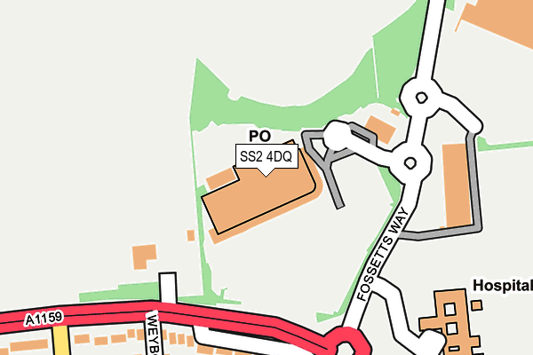
SS2 4DQ is located in the St. Luke's electoral ward, within the unitary authority of Southend-on-Sea and the English Parliamentary constituency of Rochford and Southend East. The Sub Integrated Care Board (ICB) Location is NHS Mid and South Essex ICB - 99G and the police force is Essex. This postcode has been in use since December 1994.


GetTheData
Source: OS OpenMap – Local (Ordnance Survey)
Source: OS VectorMap District (Ordnance Survey)
Licence: Open Government Licence (requires attribution)
| Easting | 588973 |
| Northing | 187627 |
| Latitude | 51.555868 |
| Longitude | 0.724546 |
GetTheData
Source: Open Postcode Geo
Licence: Open Government Licence
| Country | England |
| Postcode District | SS2 |
| ➜ SS2 open data dashboard ➜ See where SS2 is on a map ➜ Where is Southend-on-Sea? | |
GetTheData
Source: Land Registry Price Paid Data
Licence: Open Government Licence
Elevation or altitude of SS2 4DQ as distance above sea level:
| Metres | Feet | |
|---|---|---|
| Elevation | 20m | 66ft |
Elevation is measured from the approximate centre of the postcode, to the nearest point on an OS contour line from OS Terrain 50, which has contour spacing of ten vertical metres.
➜ How high above sea level am I? Find the elevation of your current position using your device's GPS.
GetTheData
Source: Open Postcode Elevation
Licence: Open Government Licence
| Ward | St. Luke's |
| Constituency | Rochford And Southend East |
GetTheData
Source: ONS Postcode Database
Licence: Open Government Licence
| January 2024 | Shoplifting | On or near Fossetts Way | 92m |
| January 2024 | Shoplifting | On or near Fossetts Way | 92m |
| January 2024 | Shoplifting | On or near Fossetts Way | 92m |
| ➜ Get more crime data in our Crime section | |||
GetTheData
Source: data.police.uk
Licence: Open Government Licence
| B & Q Warehouse (Fossetts Way) | Southchurch | 147m |
| Wellsley Hospital (Fossetts Way) | Southchurch | 158m |
| Fossetts Way (Eastern Avenue) | Southchurch | 272m |
| Bournemouth Park Road Northend (Bournemouth Park Road) | Southchurch | 305m |
| Eastern Avenue (Bournemouth Park Road) | Southchurch | 309m |
| Prittlewell Station | 1.1km |
| Southend Victoria Station | 1.8km |
| Southend East Station | 1.9km |
GetTheData
Source: NaPTAN
Licence: Open Government Licence
GetTheData
Source: ONS Postcode Database
Licence: Open Government Licence


➜ Get more ratings from the Food Standards Agency
GetTheData
Source: Food Standards Agency
Licence: FSA terms & conditions
| Last Collection | |||
|---|---|---|---|
| Location | Mon-Fri | Sat | Distance |
| Waitrose | 18:30 | 13:00 | 25m |
| Cluny Square Post Office | 17:30 | 11:30 | 529m |
| Stock Road | 18:30 | 11:30 | 601m |
GetTheData
Source: Dracos
Licence: Creative Commons Attribution-ShareAlike
| Facility | Distance |
|---|---|
| Southend United Fc Training Ground Eastern Avenue, Southend-on-sea Grass Pitches | 162m |
| Cecil Jones Academy Playing Fields Eastern Avenue, Southend-on-sea Grass Pitches, Artificial Grass Pitch | 173m |
| Puregym (Southend Fossetts Park) Fossetts Way, Eastern Avenue, Southend-on-sea Health and Fitness Gym | 217m |
GetTheData
Source: Active Places
Licence: Open Government Licence
| School | Phase of Education | Distance |
|---|---|---|
| Temple Sutton Primary School Eastern Avenue, Southend-on-Sea, SS2 4BA | Primary | 475m |
| Victory Park Academy Wentworth Road, Southend-On-Sea, SS2 5LG | Not applicable | 476m |
| Sutton House Academy Wentworth Road, Southend-On-Sea, SS2 5LG | Not applicable | 481m |
GetTheData
Source: Edubase
Licence: Open Government Licence
The below table lists the International Territorial Level (ITL) codes (formerly Nomenclature of Territorial Units for Statistics (NUTS) codes) and Local Administrative Units (LAU) codes for SS2 4DQ:
| ITL 1 Code | Name |
|---|---|
| TLH | East |
| ITL 2 Code | Name |
| TLH3 | Essex |
| ITL 3 Code | Name |
| TLH31 | Southend-on-Sea |
| LAU 1 Code | Name |
| E06000033 | Southend-on-Sea |
GetTheData
Source: ONS Postcode Directory
Licence: Open Government Licence
The below table lists the Census Output Area (OA), Lower Layer Super Output Area (LSOA), and Middle Layer Super Output Area (MSOA) for SS2 4DQ:
| Code | Name | |
|---|---|---|
| OA | E00080258 | |
| LSOA | E01015871 | Southend-on-Sea 006C |
| MSOA | E02003284 | Southend-on-Sea 006 |
GetTheData
Source: ONS Postcode Directory
Licence: Open Government Licence
| SS2 4AZ | Eastern Avenue | 203m |
| SS2 4HF | Fossetts Drive | 211m |
| SS2 4AT | Eastern Avenue | 260m |
| SS2 4AY | Waltham Crescent | 279m |
| SS2 4AU | Weybourne Gardens | 324m |
| SS2 4AX | Weybourne Close | 325m |
| SS2 4BT | Royston Avenue | 342m |
| SS2 5NH | Eastern Avenue | 344m |
| SS2 5LZ | Bournemouth Park Road | 372m |
| SS2 4BP | Royston Avenue | 373m |
GetTheData
Source: Open Postcode Geo; Land Registry Price Paid Data
Licence: Open Government Licence