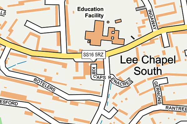
SS16 5RZ is located in the Nethermayne electoral ward, within the local authority district of Basildon and the English Parliamentary constituency of South Basildon and East Thurrock. The Sub Integrated Care Board (ICB) Location is NHS Mid and South Essex ICB - 99E and the police force is Essex. This postcode has been in use since January 1980.


GetTheData
Source: OS OpenMap – Local (Ordnance Survey)
Source: OS VectorMap District (Ordnance Survey)
Licence: Open Government Licence (requires attribution)
| Easting | 569591 |
| Northing | 187841 |
| Latitude | 51.563949 |
| Longitude | 0.445383 |
GetTheData
Source: Open Postcode Geo
Licence: Open Government Licence
| Country | England |
| Postcode District | SS16 |
| ➜ SS16 open data dashboard ➜ See where SS16 is on a map ➜ Where is Basildon? | |
GetTheData
Source: Land Registry Price Paid Data
Licence: Open Government Licence
Elevation or altitude of SS16 5RZ as distance above sea level:
| Metres | Feet | |
|---|---|---|
| Elevation | 40m | 131ft |
Elevation is measured from the approximate centre of the postcode, to the nearest point on an OS contour line from OS Terrain 50, which has contour spacing of ten vertical metres.
➜ How high above sea level am I? Find the elevation of your current position using your device's GPS.
GetTheData
Source: Open Postcode Elevation
Licence: Open Government Licence
| Ward | Nethermayne |
| Constituency | South Basildon And East Thurrock |
GetTheData
Source: ONS Postcode Database
Licence: Open Government Licence
| January 2024 | Other theft | On or near Great Gregorie | 298m |
| January 2024 | Criminal damage and arson | On or near Great Gregorie | 298m |
| December 2023 | Violence and sexual offences | On or near Great Gregorie | 298m |
| ➜ Get more crime data in our Crime section | |||
GetTheData
Source: data.police.uk
Licence: Open Government Licence
| Castlemayne (The Knares) | Basildon | 37m |
| Castlemayne (The Knares) | Basildon | 99m |
| Botelers (The Knares) | Basildon | 231m |
| Botelers (The Knares) | Basildon | 259m |
| Raintree Fold (The Knares) | Basildon | 422m |
| Basildon Station | 0.9km |
| Laindon Station | 1.5km |
| Pitsea Station | 4.2km |
GetTheData
Source: NaPTAN
Licence: Open Government Licence
GetTheData
Source: ONS Postcode Database
Licence: Open Government Licence


➜ Get more ratings from the Food Standards Agency
GetTheData
Source: Food Standards Agency
Licence: FSA terms & conditions
| Last Collection | |||
|---|---|---|---|
| Location | Mon-Fri | Sat | Distance |
| Cherrydown | 17:30 | 11:30 | 588m |
| Waldergrave | 17:30 | 11:30 | 977m |
| Somercotes | 17:30 | 11:45 | 1,193m |
GetTheData
Source: Dracos
Licence: Creative Commons Attribution-ShareAlike
| Facility | Distance |
|---|---|
| Lee Chapel Primary School The Knares, Basildon Grass Pitches, Artificial Grass Pitch, Sports Hall, Swimming Pool | 89m |
| South Essex College (Basildon Campus) (Closed) Nethermayne, Basildon Sports Hall, Health and Fitness Gym, Squash Courts | 427m |
| Woodlands School (Basildon) Woodlands Approach, Basildon Health and Fitness Gym, Grass Pitches, Sports Hall, Artificial Grass Pitch | 713m |
GetTheData
Source: Active Places
Licence: Open Government Licence
| School | Phase of Education | Distance |
|---|---|---|
| Lee Chapel Primary School The Knares, Basildon, SS16 5RU | Primary | 89m |
| St Anne Line Catholic Junior School Wickhay, Basildon, SS15 5AF | Primary | 729m |
| St Anne Line Catholic Infant School Wickhay, Basildon, SS15 5AF | Primary | 729m |
GetTheData
Source: Edubase
Licence: Open Government Licence
The below table lists the International Territorial Level (ITL) codes (formerly Nomenclature of Territorial Units for Statistics (NUTS) codes) and Local Administrative Units (LAU) codes for SS16 5RZ:
| ITL 1 Code | Name |
|---|---|
| TLH | East |
| ITL 2 Code | Name |
| TLH3 | Essex |
| ITL 3 Code | Name |
| TLH37 | Essex Thames Gateway |
| LAU 1 Code | Name |
| E07000066 | Basildon |
GetTheData
Source: ONS Postcode Directory
Licence: Open Government Licence
The below table lists the Census Output Area (OA), Lower Layer Super Output Area (LSOA), and Middle Layer Super Output Area (MSOA) for SS16 5RZ:
| Code | Name | |
|---|---|---|
| OA | E00108186 | |
| LSOA | E01021294 | Basildon 020A |
| MSOA | E02004443 | Basildon 020 |
GetTheData
Source: ONS Postcode Directory
Licence: Open Government Licence
| SS16 5ST | The Knares | 90m |
| SS16 5TZ | Little Dodden | 107m |
| SS16 5TY | Renacres | 119m |
| SS16 5SE | Botelers | 139m |
| SS16 5TD | The Knares | 180m |
| SS16 5TN | Gernons | 181m |
| SS16 5QX | Great Gregorie | 191m |
| SS16 5TX | Morrells | 191m |
| SS16 5SB | The Knares | 195m |
| SS16 5SH | Gaynesford | 195m |
GetTheData
Source: Open Postcode Geo; Land Registry Price Paid Data
Licence: Open Government Licence