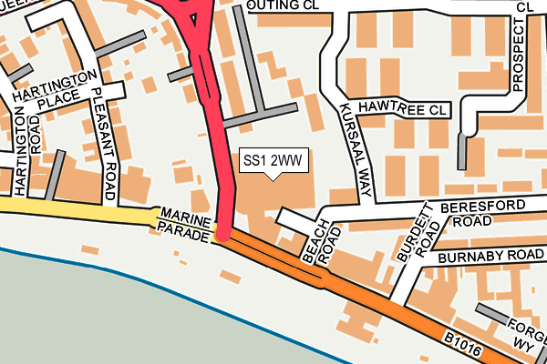
SS1 2WW is located in the Kursaal electoral ward, within the unitary authority of Southend-on-Sea and the English Parliamentary constituency of Rochford and Southend East. The Sub Integrated Care Board (ICB) Location is NHS Mid and South Essex ICB - 99G and the police force is Essex. This postcode has been in use since June 1998.


GetTheData
Source: OS OpenMap – Local (Ordnance Survey)
Source: OS VectorMap District (Ordnance Survey)
Licence: Open Government Licence (requires attribution)
| Easting | 589088 |
| Northing | 185093 |
| Latitude | 51.533071 |
| Longitude | 0.724842 |
GetTheData
Source: Open Postcode Geo
Licence: Open Government Licence
| Country | England |
| Postcode District | SS1 |
➜ See where SS1 is on a map ➜ Where is Southend-on-Sea? | |
GetTheData
Source: Land Registry Price Paid Data
Licence: Open Government Licence
Elevation or altitude of SS1 2WW as distance above sea level:
| Metres | Feet | |
|---|---|---|
| Elevation | 10m | 33ft |
Elevation is measured from the approximate centre of the postcode, to the nearest point on an OS contour line from OS Terrain 50, which has contour spacing of ten vertical metres.
➜ How high above sea level am I? Find the elevation of your current position using your device's GPS.
GetTheData
Source: Open Postcode Elevation
Licence: Open Government Licence
| Ward | Kursaal |
| Constituency | Rochford And Southend East |
GetTheData
Source: ONS Postcode Database
Licence: Open Government Licence
| Southchurch Avenue | Southend-on-sea | 106m |
| Southchurch Avenue | Southend-on-sea | 111m |
| Kursaal (Eastern Esplanade) | Southend-on-sea | 142m |
| Burdett Road (Eastern Esplanade) | Southend-on-sea | 214m |
| Woodgrange Ph (Woodgrange Drive) | Southchurch | 248m |
| Southend East Station | 0.8km |
| Southend Central Station | 1km |
| Southend Victoria Station | 1.3km |
GetTheData
Source: NaPTAN
Licence: Open Government Licence
GetTheData
Source: ONS Postcode Database
Licence: Open Government Licence


➜ Get more ratings from the Food Standards Agency
GetTheData
Source: Food Standards Agency
Licence: FSA terms & conditions
| Last Collection | |||
|---|---|---|---|
| Location | Mon-Fri | Sat | Distance |
| Brittania P/House | 17:30 | 11:30 | 79m |
| Hawtree Close | 17:30 | 11:30 | 215m |
| 180 York Road | 17:30 | 11:30 | 401m |
GetTheData
Source: Dracos
Licence: Creative Commons Attribution-ShareAlike
| Risk of SS1 2WW flooding from rivers and sea | Low |
| ➜ SS1 2WW flood map | |
GetTheData
Source: Open Flood Risk by Postcode
Licence: Open Government Licence
The below table lists the International Territorial Level (ITL) codes (formerly Nomenclature of Territorial Units for Statistics (NUTS) codes) and Local Administrative Units (LAU) codes for SS1 2WW:
| ITL 1 Code | Name |
|---|---|
| TLH | East |
| ITL 2 Code | Name |
| TLH3 | Essex |
| ITL 3 Code | Name |
| TLH31 | Southend-on-Sea |
| LAU 1 Code | Name |
| E06000033 | Southend-on-Sea |
GetTheData
Source: ONS Postcode Directory
Licence: Open Government Licence
The below table lists the Census Output Area (OA), Lower Layer Super Output Area (LSOA), and Middle Layer Super Output Area (MSOA) for SS1 2WW:
| Code | Name | |
|---|---|---|
| OA | E00080089 | |
| LSOA | E01015842 | Southend-on-Sea 014D |
| MSOA | E02003292 | Southend-on-Sea 014 |
GetTheData
Source: ONS Postcode Directory
Licence: Open Government Licence
| SS1 2TR | Beach Road | 80m |
| SS1 2ER | Eastern Esplanade | 98m |
| SS1 2RQ | Marks Court | 103m |
| SS1 2RH | Marks Court | 107m |
| SS1 2EZ | Albion Villas | 174m |
| SS1 2RJ | Marks Court | 183m |
| SS1 2EY | Southchurch Avenue | 187m |
| SS1 2EN | Marine Parade | 197m |
| SS1 2HX | Pleasant Mews | 199m |
| SS1 2TW | Beresford Road | 199m |
GetTheData
Source: Open Postcode Geo; Land Registry Price Paid Data
Licence: Open Government Licence