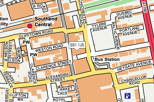
SS1 1JS is located in the Milton electoral ward, within the unitary authority of Southend-on-Sea and the English Parliamentary constituency of Rochford and Southend East. The Sub Integrated Care Board (ICB) Location is NHS Mid and South Essex ICB - 99G and the police force is Essex. This postcode has been in use since January 1980.


GetTheData
Source: OS OpenMap – Local (Ordnance Survey)
Source: OS VectorMap District (Ordnance Survey)
Licence: Open Government Licence (requires attribution)
| Easting | 588333 |
| Northing | 185417 |
| Latitude | 51.536234 |
| Longitude | 0.714143 |
GetTheData
Source: Open Postcode Geo
Licence: Open Government Licence
| Country | England |
| Postcode District | SS1 |
| ➜ SS1 open data dashboard ➜ See where SS1 is on a map ➜ Where is Southend-on-Sea? | |
GetTheData
Source: Land Registry Price Paid Data
Licence: Open Government Licence
Elevation or altitude of SS1 1JS as distance above sea level:
| Metres | Feet | |
|---|---|---|
| Elevation | 20m | 66ft |
Elevation is measured from the approximate centre of the postcode, to the nearest point on an OS contour line from OS Terrain 50, which has contour spacing of ten vertical metres.
➜ How high above sea level am I? Find the elevation of your current position using your device's GPS.
GetTheData
Source: Open Postcode Elevation
Licence: Open Government Licence
| Ward | Milton |
| Constituency | Rochford And Southend East |
GetTheData
Source: ONS Postcode Database
Licence: Open Government Licence
| January 2024 | Anti-social behaviour | On or near Nightclub | 354m |
| January 2024 | Anti-social behaviour | On or near Nightclub | 354m |
| January 2024 | Criminal damage and arson | On or near Nightclub | 354m |
| ➜ Get more crime data in our Crime section | |||
GetTheData
Source: data.police.uk
Licence: Open Government Licence
| Travel Centre (Chichester Road) | Southend-on-sea | 39m |
| Travel Centre (Chichester Road) | Southend-on-sea | 43m |
| Travel Centre (Chichester Road) | Southend-on-sea | 49m |
| Travel Centre (Chichester Road) | Southend-on-sea | 52m |
| Travel Centre (Chichester Road) | Southend-on-sea | 58m |
| Southend Central Station | 0.2km |
| Southend Victoria Station | 0.6km |
| Southend East Station | 1.3km |
GetTheData
Source: NaPTAN
Licence: Open Government Licence
GetTheData
Source: ONS Postcode Database
Licence: Open Government Licence


➜ Get more ratings from the Food Standards Agency
GetTheData
Source: Food Standards Agency
Licence: FSA terms & conditions
| Last Collection | |||
|---|---|---|---|
| Location | Mon-Fri | Sat | Distance |
| York Road | 17:30 | 11:30 | 28m |
| York Road | 17:30 | 11:30 | 30m |
| Central Station | 18:30 | 11:30 | 157m |
GetTheData
Source: Dracos
Licence: Creative Commons Attribution-ShareAlike
| Facility | Distance |
|---|---|
| The Locker Room Clifftown Road, Southend-on-sea Health and Fitness Gym | 195m |
| Energie Fitness (Southend) High Street, High Street, Southend-on-sea Health and Fitness Gym | 197m |
| Warriors Swim Centre (Closed) Warrior Square, Southend-on-sea Swimming Pool, Health and Fitness Gym | 336m |
GetTheData
Source: Active Places
Licence: Open Government Licence
| School | Phase of Education | Distance |
|---|---|---|
| South Essex College of Further and Higher Education Luker Road, Southend-on-Sea, SS1 1ND | 16 plus | 477m |
| Porters Grange Primary School and Nursery Lancaster Gardens, Southend-on-Sea, SS1 2NS | Primary | 527m |
| Barons Court Primary School and Nursery Avenue Road, Westcliff-on-Sea, SS0 7PJ | Primary | 817m |
GetTheData
Source: Edubase
Licence: Open Government Licence
The below table lists the International Territorial Level (ITL) codes (formerly Nomenclature of Territorial Units for Statistics (NUTS) codes) and Local Administrative Units (LAU) codes for SS1 1JS:
| ITL 1 Code | Name |
|---|---|
| TLH | East |
| ITL 2 Code | Name |
| TLH3 | Essex |
| ITL 3 Code | Name |
| TLH31 | Southend-on-Sea |
| LAU 1 Code | Name |
| E06000033 | Southend-on-Sea |
GetTheData
Source: ONS Postcode Directory
Licence: Open Government Licence
The below table lists the Census Output Area (OA), Lower Layer Super Output Area (LSOA), and Middle Layer Super Output Area (MSOA) for SS1 1JS:
| Code | Name | |
|---|---|---|
| OA | E00080144 | |
| LSOA | E01015852 | Southend-on-Sea 015B |
| MSOA | E02003293 | Southend-on-Sea 015 |
GetTheData
Source: ONS Postcode Directory
Licence: Open Government Licence
| SS1 1JF | High Street | 40m |
| SS1 1HZ | High Street | 47m |
| SS1 1JG | High Street | 55m |
| SS1 1HS | High Street | 89m |
| SS1 1BH | Clarence Street | 113m |
| SS1 1AS | Weston Road | 117m |
| SS1 1BD | Clarence Street | 119m |
| SS1 2BD | York Road | 126m |
| SS1 1BX | Alexandra Street | 136m |
| SS1 1AB | Clifftown Road | 137m |
GetTheData
Source: Open Postcode Geo; Land Registry Price Paid Data
Licence: Open Government Licence