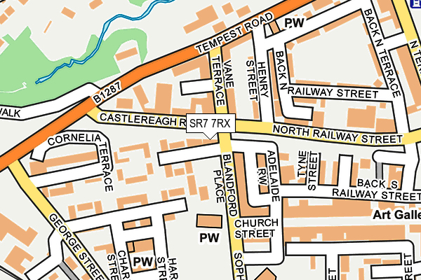
SR7 7RX is located in the Dawdon electoral ward, within the unitary authority of County Durham and the English Parliamentary constituency of Easington. The Sub Integrated Care Board (ICB) Location is NHS North East and North Cumbria ICB - 84H and the police force is Durham. This postcode has been in use since January 1980.


GetTheData
Source: OS OpenMap – Local (Ordnance Survey)
Source: OS VectorMap District (Ordnance Survey)
Licence: Open Government Licence (requires attribution)
| Easting | 442704 |
| Northing | 549450 |
| Latitude | 54.838058 |
| Longitude | -1.336638 |
GetTheData
Source: Open Postcode Geo
Licence: Open Government Licence
| Country | England |
| Postcode District | SR7 |
| ➜ SR7 open data dashboard ➜ See where SR7 is on a map ➜ Where is Seaham? | |
GetTheData
Source: Land Registry Price Paid Data
Licence: Open Government Licence
Elevation or altitude of SR7 7RX as distance above sea level:
| Metres | Feet | |
|---|---|---|
| Elevation | 30m | 98ft |
Elevation is measured from the approximate centre of the postcode, to the nearest point on an OS contour line from OS Terrain 50, which has contour spacing of ten vertical metres.
➜ How high above sea level am I? Find the elevation of your current position using your device's GPS.
GetTheData
Source: Open Postcode Elevation
Licence: Open Government Licence
| Ward | Dawdon |
| Constituency | Easington |
GetTheData
Source: ONS Postcode Database
Licence: Open Government Licence
| January 2024 | Violence and sexual offences | On or near Queen Street | 451m |
| December 2023 | Violence and sexual offences | On or near Vane Terrace | 82m |
| November 2023 | Violence and sexual offences | On or near Vane Terrace | 82m |
| ➜ Get more crime data in our Crime section | |||
GetTheData
Source: data.police.uk
Licence: Open Government Licence
| Vane Terrace - Castlereagh (Vane Terrace) | Seaham | 53m |
| Vane Terrace - Castlereagh (Vane Terrace) | Seaham | 58m |
| North Railway Street | Seaham | 97m |
| Sophia Street | Seaham | 158m |
| Sophia Street | Seaham | 168m |
| Seaham Station | 0.6km |
GetTheData
Source: NaPTAN
Licence: Open Government Licence
| Percentage of properties with Next Generation Access | 100.0% |
| Percentage of properties with Superfast Broadband | 100.0% |
| Percentage of properties with Ultrafast Broadband | 0.0% |
| Percentage of properties with Full Fibre Broadband | 0.0% |
Superfast Broadband is between 30Mbps and 300Mbps
Ultrafast Broadband is > 300Mbps
| Percentage of properties unable to receive 2Mbps | 0.0% |
| Percentage of properties unable to receive 5Mbps | 0.0% |
| Percentage of properties unable to receive 10Mbps | 0.0% |
| Percentage of properties unable to receive 30Mbps | 0.0% |
GetTheData
Source: Ofcom
Licence: Ofcom Terms of Use (requires attribution)
GetTheData
Source: ONS Postcode Database
Licence: Open Government Licence


➜ Get more ratings from the Food Standards Agency
GetTheData
Source: Food Standards Agency
Licence: FSA terms & conditions
| Last Collection | |||
|---|---|---|---|
| Location | Mon-Fri | Sat | Distance |
| Station Road North | 16:45 | 11:30 | 134m |
| Ryhope Post Office | 17:15 | 11:45 | 3,794m |
| Dunelm Road, Hetton Le Hole | 17:30 | 11:45 | 6,141m |
GetTheData
Source: Dracos
Licence: Creative Commons Attribution-ShareAlike
| Facility | Distance |
|---|---|
| Bruces Gym Vane Terrace, Seaham Health and Fitness Gym, Studio | 76m |
| Princess Road Junior School (Closed) Princess Road, Seaham Grass Pitches | 454m |
| Ropery Walk Primary School Ropery Walk, Seaham Sports Hall, Artificial Grass Pitch | 620m |
GetTheData
Source: Active Places
Licence: Open Government Licence
| School | Phase of Education | Distance |
|---|---|---|
| Seaham Trinity Primary School Princess Road, Seaham, SR7 7SP | Primary | 378m |
| St Mary Magdalen's Catholic Primary School Dene House Road, St. Mary Magdalene Rc Primary School, Dene House Road, SEAHAM, SR7 7BJ | Primary | 392m |
| Ropery Walk Primary School Ropery Walk, Seaham, SR7 7JZ | Primary | 620m |
GetTheData
Source: Edubase
Licence: Open Government Licence
The below table lists the International Territorial Level (ITL) codes (formerly Nomenclature of Territorial Units for Statistics (NUTS) codes) and Local Administrative Units (LAU) codes for SR7 7RX:
| ITL 1 Code | Name |
|---|---|
| TLC | North East (England) |
| ITL 2 Code | Name |
| TLC1 | Tees Valley and Durham |
| ITL 3 Code | Name |
| TLC14 | Durham |
| LAU 1 Code | Name |
| E06000047 | County Durham |
GetTheData
Source: ONS Postcode Directory
Licence: Open Government Licence
The below table lists the Census Output Area (OA), Lower Layer Super Output Area (LSOA), and Middle Layer Super Output Area (MSOA) for SR7 7RX:
| Code | Name | |
|---|---|---|
| OA | E00105458 | |
| LSOA | E01020784 | County Durham 017F |
| MSOA | E02004321 | County Durham 017 |
GetTheData
Source: ONS Postcode Directory
Licence: Open Government Licence
| SR7 7EN | South Railway Street | 48m |
| SR7 7EL | Blandford Place | 64m |
| SR7 7SD | Marlborough | 66m |
| SR7 7AU | Vane Terrace | 68m |
| SR7 7SA | Marlborough | 97m |
| SR7 7EF | Adelaide Row | 97m |
| SR7 7EJ | Church Street | 115m |
| SR7 7BZ | Henry Street | 121m |
| SR7 7DA | North Railway Street | 137m |
| SR7 7DE | Tees Street | 144m |
GetTheData
Source: Open Postcode Geo; Land Registry Price Paid Data
Licence: Open Government Licence