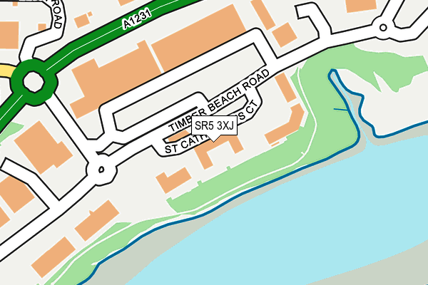
SR5 3XJ lies on St Catherines Court in Sunderland Enterprise Park, Sunderland. SR5 3XJ is located in the Castle electoral ward, within the metropolitan district of Sunderland and the English Parliamentary constituency of Washington and Sunderland West. The Sub Integrated Care Board (ICB) Location is NHS North East and North Cumbria ICB - 00P and the police force is Northumbria. This postcode has been in use since July 1995.


GetTheData
Source: OS OpenMap – Local (Ordnance Survey)
Source: OS VectorMap District (Ordnance Survey)
Licence: Open Government Licence (requires attribution)
| Easting | 436614 |
| Northing | 558189 |
| Latitude | 54.917066 |
| Longitude | -1.430345 |
GetTheData
Source: Open Postcode Geo
Licence: Open Government Licence
| Street | St Catherines Court |
| Locality | Sunderland Enterprise Park |
| Town/City | Sunderland |
| Country | England |
| Postcode District | SR5 |
| ➜ SR5 open data dashboard ➜ See where SR5 is on a map ➜ Where is Sunderland? | |
GetTheData
Source: Land Registry Price Paid Data
Licence: Open Government Licence
Elevation or altitude of SR5 3XJ as distance above sea level:
| Metres | Feet | |
|---|---|---|
| Elevation | 10m | 33ft |
Elevation is measured from the approximate centre of the postcode, to the nearest point on an OS contour line from OS Terrain 50, which has contour spacing of ten vertical metres.
➜ How high above sea level am I? Find the elevation of your current position using your device's GPS.
GetTheData
Source: Open Postcode Elevation
Licence: Open Government Licence
| Ward | Castle |
| Constituency | Washington And Sunderland West |
GetTheData
Source: ONS Postcode Database
Licence: Open Government Licence
| June 2022 | Shoplifting | On or near St Catherine'S Court | 20m |
| June 2022 | Violence and sexual offences | On or near St Catherine'S Court | 20m |
| June 2022 | Bicycle theft | On or near Hylton Park Road | 299m |
| ➜ Get more crime data in our Crime section | |||
GetTheData
Source: data.police.uk
Licence: Open Government Licence
| Timber Beach Road | Enterprise Park | 50m |
| Timber Beach Road | Enterprise Park | 79m |
| Colima Avenue | Enterprise Park | 200m |
| Hylton Park Road (Hylton Park) | Enterprise Park | 343m |
| Chaffinch Road | Castletown | 354m |
| Pallion (Tyne And Wear Metro Station) (European Way) | Pallion | 971m |
| South Hylton (Tyne And Wear Metro Station) (High Street / Hylton Bank) | South Hylton | 1,866m |
| St Peters Station | 3km |
| Seaburn Station | 3.1km |
| East Boldon Station | 3.3km |
GetTheData
Source: NaPTAN
Licence: Open Government Licence
GetTheData
Source: ONS Postcode Database
Licence: Open Government Licence


➜ Get more ratings from the Food Standards Agency
GetTheData
Source: Food Standards Agency
Licence: FSA terms & conditions
| Last Collection | |||
|---|---|---|---|
| Location | Mon-Fri | Sat | Distance |
| Pallion Way | 19:00 | 12:15 | 932m |
| Fordham Road | 17:00 | 12:30 | 1,087m |
| Maling Park | 16:15 | 10:30 | 1,338m |
GetTheData
Source: Dracos
Licence: Creative Commons Attribution-ShareAlike
| Facility | Distance |
|---|---|
| Everlast Gyms (Sunderland) Hylton Retail Park, Timber Beach Road, Sunderland Enterprise Park, Sunderland Health and Fitness Gym, Swimming Pool, Studio | 286m |
| Springs Sanctuary Spa (Sunderland) (Closed) Hylton Retail Park, Timber Beach Road, Sunderland Enterprise Park, Sunderland Studio, Swimming Pool, Health and Fitness Gym | 289m |
| Northern Saints C Of E Voluntary Aided Primary School Rotherham Road, Sunderland Grass Pitches | 702m |
GetTheData
Source: Active Places
Licence: Open Government Licence
| School | Phase of Education | Distance |
|---|---|---|
| Hylton Red House Nursery School Rotherham Road, Red House Estate, Sunderland, SR5 5QL | Nursery | 622m |
| Northern Saints Church of England Academy Rotherham Road, Sunderland, SR5 5QL | Primary | 773m |
| Castletown Primary School Grange Road, Castletown, Castletown Primary School, Sunderland, SR5 3EQ | Primary | 944m |
GetTheData
Source: Edubase
Licence: Open Government Licence
The below table lists the International Territorial Level (ITL) codes (formerly Nomenclature of Territorial Units for Statistics (NUTS) codes) and Local Administrative Units (LAU) codes for SR5 3XJ:
| ITL 1 Code | Name |
|---|---|
| TLC | North East (England) |
| ITL 2 Code | Name |
| TLC2 | Northumberland, and Tyne and Wear |
| ITL 3 Code | Name |
| TLC23 | Sunderland |
| LAU 1 Code | Name |
| E08000024 | Sunderland |
GetTheData
Source: ONS Postcode Directory
Licence: Open Government Licence
The below table lists the Census Output Area (OA), Lower Layer Super Output Area (LSOA), and Middle Layer Super Output Area (MSOA) for SR5 3XJ:
| Code | Name | |
|---|---|---|
| OA | E00044158 | |
| LSOA | E01008693 | Sunderland 008A |
| MSOA | E02001798 | Sunderland 008 |
GetTheData
Source: ONS Postcode Directory
Licence: Open Government Licence
| SR5 3XG | Timber Beach Road | 142m |
| SR5 3AH | Dene Road | 404m |
| SR5 3AY | Dene Mews | 414m |
| SR5 3AJ | Castle View | 429m |
| SR5 3AU | East View | 437m |
| SR5 3FB | Aydon Road | 491m |
| SR5 3FD | Fairleigh Road | 493m |
| SR5 3AB | Sherbourne Road | 496m |
| SR5 3AQ | The Villas | 506m |
| SR5 3AL | Castle View | 509m |
GetTheData
Source: Open Postcode Geo; Land Registry Price Paid Data
Licence: Open Government Licence