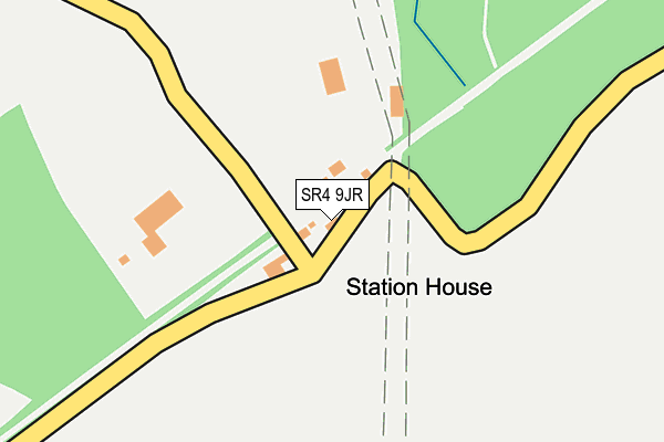
SR4 9JR is located in the Shiney Row electoral ward, within the metropolitan district of Sunderland and the English Parliamentary constituency of Houghton and Sunderland South. The Sub Integrated Care Board (ICB) Location is NHS North East and North Cumbria ICB - 00P and the police force is Northumbria. This postcode has been in use since January 1980.


GetTheData
Source: OS OpenMap – Local (Ordnance Survey)
Source: OS VectorMap District (Ordnance Survey)
Licence: Open Government Licence (requires attribution)
| Easting | 433090 |
| Northing | 554914 |
| Latitude | 54.887883 |
| Longitude | -1.485693 |
GetTheData
Source: Open Postcode Geo
Licence: Open Government Licence
| Country | England |
| Postcode District | SR4 |
| ➜ SR4 open data dashboard ➜ See where SR4 is on a map | |
GetTheData
Source: Land Registry Price Paid Data
Licence: Open Government Licence
Elevation or altitude of SR4 9JR as distance above sea level:
| Metres | Feet | |
|---|---|---|
| Elevation | 40m | 131ft |
Elevation is measured from the approximate centre of the postcode, to the nearest point on an OS contour line from OS Terrain 50, which has contour spacing of ten vertical metres.
➜ How high above sea level am I? Find the elevation of your current position using your device's GPS.
GetTheData
Source: Open Postcode Elevation
Licence: Open Government Licence
| Ward | Shiney Row |
| Constituency | Houghton And Sunderland South |
GetTheData
Source: ONS Postcode Database
Licence: Open Government Licence
| Chester Road-monument (Chester Road) | Penshaw | 823m |
| Chester Road-monument (Chester Road) | Penshaw | 849m |
| Teal Farm (Pattinson Road) | Barnes Park | 924m |
| Chester Road-flinton Hill Farm (Chester Road) | Penshaw | 940m |
| Chester Road-flinton Hill Farm (Chester Road) | Penshaw | 951m |
GetTheData
Source: NaPTAN
Licence: Open Government Licence
| Percentage of properties with Next Generation Access | 0.0% |
| Percentage of properties with Superfast Broadband | 0.0% |
| Percentage of properties with Ultrafast Broadband | 0.0% |
| Percentage of properties with Full Fibre Broadband | 0.0% |
Superfast Broadband is between 30Mbps and 300Mbps
Ultrafast Broadband is > 300Mbps
| Percentage of properties unable to receive 2Mbps | 0.0% |
| Percentage of properties unable to receive 5Mbps | 100.0% |
| Percentage of properties unable to receive 10Mbps | 100.0% |
| Percentage of properties unable to receive 30Mbps | 100.0% |
GetTheData
Source: Ofcom
Licence: Ofcom Terms of Use (requires attribution)
GetTheData
Source: ONS Postcode Database
Licence: Open Government Licence


➜ Get more ratings from the Food Standards Agency
GetTheData
Source: Food Standards Agency
Licence: FSA terms & conditions
| Last Collection | |||
|---|---|---|---|
| Location | Mon-Fri | Sat | Distance |
| Pattinson Road | 16:30 | 10:30 | 1,097m |
| Gowanburn | 16:45 | 10:30 | 1,474m |
| Lee Close | 16:15 | 10:30 | 1,667m |
GetTheData
Source: Dracos
Licence: Creative Commons Attribution-ShareAlike
| Facility | Distance |
|---|---|
| Wearside Golf Club Coxgreen, Sunderland Golf | 670m |
| New Penshaw Academy Langdale Road, Penshaw, Houghton Le Spring Grass Pitches | 1.3km |
| Barnwell Academy Whitefield Estate, Penshaw, Houghton Le Spring Sports Hall, Grass Pitches, Artificial Grass Pitch | 1.8km |
GetTheData
Source: Active Places
Licence: Open Government Licence
| School | Phase of Education | Distance |
|---|---|---|
| New Penshaw Academy Langdale Road, New Penshaw, Houghton le Spring, DH4 7HY | Primary | 1.4km |
| Columbia Grange School Oxclose Road, Washington, NE38 7NY | Not applicable | 1.7km |
| Barnwell Academy Whitefield Estate, Penshaw, Houghton le Spring, DH4 7RT | Primary | 1.8km |
GetTheData
Source: Edubase
Licence: Open Government Licence
The below table lists the International Territorial Level (ITL) codes (formerly Nomenclature of Territorial Units for Statistics (NUTS) codes) and Local Administrative Units (LAU) codes for SR4 9JR:
| ITL 1 Code | Name |
|---|---|
| TLC | North East (England) |
| ITL 2 Code | Name |
| TLC2 | Northumberland, and Tyne and Wear |
| ITL 3 Code | Name |
| TLC23 | Sunderland |
| LAU 1 Code | Name |
| E08000024 | Sunderland |
GetTheData
Source: ONS Postcode Directory
Licence: Open Government Licence
The below table lists the Census Output Area (OA), Lower Layer Super Output Area (LSOA), and Middle Layer Super Output Area (MSOA) for SR4 9JR:
| Code | Name | |
|---|---|---|
| OA | E00165667 | |
| LSOA | E01032484 | Sunderland 032G |
| MSOA | E02001822 | Sunderland 032 |
GetTheData
Source: ONS Postcode Directory
Licence: Open Government Licence
| SR4 9JP | 461m | |
| SR4 9JS | Waterside | 493m |
| SR4 9JU | Alice Well Villas | 585m |
| NE38 8JZ | Boat Houses | 664m |
| NE38 8JX | 712m | |
| NE38 8FG | Thorncliffe Close | 723m |
| NE38 8FH | Edale Close | 729m |
| NE38 8FD | Dovestone Close | 771m |
| NE38 8JY | Jubilee Terrace | 775m |
| SR4 9JX | Chester Road | 782m |
GetTheData
Source: Open Postcode Geo; Land Registry Price Paid Data
Licence: Open Government Licence