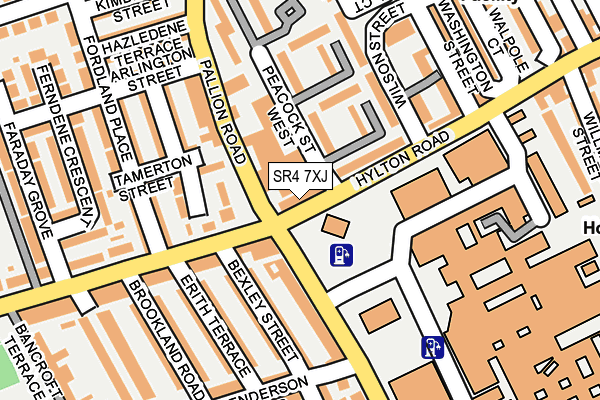
SR4 7XJ is located in the Millfield electoral ward, within the metropolitan district of Sunderland and the English Parliamentary constituency of Sunderland Central. The Sub Integrated Care Board (ICB) Location is NHS North East and North Cumbria ICB - 00P and the police force is Northumbria. This postcode has been in use since January 1980.


GetTheData
Source: OS OpenMap – Local (Ordnance Survey)
Source: OS VectorMap District (Ordnance Survey)
Licence: Open Government Licence (requires attribution)
| Easting | 437798 |
| Northing | 556770 |
| Latitude | 54.904236 |
| Longitude | -1.412075 |
GetTheData
Source: Open Postcode Geo
Licence: Open Government Licence
| Country | England |
| Postcode District | SR4 |
| ➜ SR4 open data dashboard ➜ See where SR4 is on a map ➜ Where is Sunderland? | |
GetTheData
Source: Land Registry Price Paid Data
Licence: Open Government Licence
Elevation or altitude of SR4 7XJ as distance above sea level:
| Metres | Feet | |
|---|---|---|
| Elevation | 50m | 164ft |
Elevation is measured from the approximate centre of the postcode, to the nearest point on an OS contour line from OS Terrain 50, which has contour spacing of ten vertical metres.
➜ How high above sea level am I? Find the elevation of your current position using your device's GPS.
GetTheData
Source: Open Postcode Elevation
Licence: Open Government Licence
| Ward | Millfield |
| Constituency | Sunderland Central |
GetTheData
Source: ONS Postcode Database
Licence: Open Government Licence
| January 2024 | Criminal damage and arson | On or near Pine Street | 357m |
| January 2024 | Violence and sexual offences | On or near Pine Street | 357m |
| January 2024 | Violence and sexual offences | On or near Pine Street | 357m |
| ➜ Get more crime data in our Crime section | |||
GetTheData
Source: data.police.uk
Licence: Open Government Licence
| Royal Hospital Hylton Road G (Hylton Road) | Millfield | 43m |
| Pallion Road | Ford | 50m |
| Pallion Road | Ford | 75m |
| Royal Hospital Hylton Road H (Hylton Road) | Millfield | 76m |
| Hylton Road-bexley Street (Hylton Road) | Ford | 109m |
| Millfield (Tyne And Wear Metro Station) (Hylton Road) | Millfield | 737m |
| Pallion (Tyne And Wear Metro Station) (European Way) | Pallion | 1,011m |
| University (Tyne And Wear Metro Station) (A183 Chester Road) | University Of Sunderland | 1,281m |
| Sunderland Station | 1.9km |
| St Peters Station | 2km |
| Seaburn Station | 3.3km |
GetTheData
Source: NaPTAN
Licence: Open Government Licence
GetTheData
Source: ONS Postcode Database
Licence: Open Government Licence


➜ Get more ratings from the Food Standards Agency
GetTheData
Source: Food Standards Agency
Licence: FSA terms & conditions
| Last Collection | |||
|---|---|---|---|
| Location | Mon-Fri | Sat | Distance |
| Oxford Street Post Office | 17:45 | 12:30 | 520m |
| Jackson Street | 17:45 | 12:15 | 520m |
| Chester Road West Post Office | 17:15 | 12:15 | 574m |
GetTheData
Source: Dracos
Licence: Creative Commons Attribution-ShareAlike
| Facility | Distance |
|---|---|
| Lambton Street Youth And Community Hub Falkland Road, Sunderland Sports Hall, Health and Fitness Gym | 399m |
| St Gabriels Church Sunderland St. Gabriels Avenue, Sunderland Sports Hall | 424m |
| Premier Health & Fitness Centre (Closed) Hylton Road, Sunderland Health and Fitness Gym | 475m |
GetTheData
Source: Active Places
Licence: Open Government Licence
| School | Phase of Education | Distance |
|---|---|---|
| Diamond Hall Infant Academy Well Street, Sunderland, SR4 6JF | Primary | 313m |
| Diamond Hall Junior Academy Well Street, Millfield, Sunderland, SR4 6JF | Primary | 314m |
| St Joseph's Catholic Primary School, Sunderland Rutland Street, Sunderland, SR4 6HY | Primary | 401m |
GetTheData
Source: Edubase
Licence: Open Government Licence
The below table lists the International Territorial Level (ITL) codes (formerly Nomenclature of Territorial Units for Statistics (NUTS) codes) and Local Administrative Units (LAU) codes for SR4 7XJ:
| ITL 1 Code | Name |
|---|---|
| TLC | North East (England) |
| ITL 2 Code | Name |
| TLC2 | Northumberland, and Tyne and Wear |
| ITL 3 Code | Name |
| TLC23 | Sunderland |
| LAU 1 Code | Name |
| E08000024 | Sunderland |
GetTheData
Source: ONS Postcode Directory
Licence: Open Government Licence
The below table lists the Census Output Area (OA), Lower Layer Super Output Area (LSOA), and Middle Layer Super Output Area (MSOA) for SR4 7XJ:
| Code | Name | |
|---|---|---|
| OA | E00044200 | |
| LSOA | E01008704 | Sunderland 011B |
| MSOA | E02001801 | Sunderland 011 |
GetTheData
Source: ONS Postcode Directory
Licence: Open Government Licence
| SR4 7SN | Whitehall Terrace | 90m |
| SR4 6LP | Highfield Place | 100m |
| SR4 6LR | Pallion Road | 106m |
| SR4 7TN | Kayll Road | 111m |
| SR4 7SW | Whitehall Terrace | 131m |
| SR4 7TL | Bexley Street | 131m |
| SR4 6LU | Tamerton Street | 133m |
| SR4 6LT | Ford Terrace | 133m |
| SR4 6UR | Fordland Place | 168m |
| SR4 6JR | Bell Street | 169m |
GetTheData
Source: Open Postcode Geo; Land Registry Price Paid Data
Licence: Open Government Licence