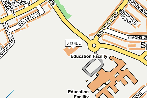
SR3 4DE is located in the Sandhill electoral ward, within the metropolitan district of Sunderland and the English Parliamentary constituency of Houghton and Sunderland South. The Sub Integrated Care Board (ICB) Location is NHS North East and North Cumbria ICB - 00P and the police force is Northumbria. This postcode has been in use since October 2005.


GetTheData
Source: OS OpenMap – Local (Ordnance Survey)
Source: OS VectorMap District (Ordnance Survey)
Licence: Open Government Licence (requires attribution)
| Easting | 436540 |
| Northing | 555039 |
| Latitude | 54.888766 |
| Longitude | -1.431898 |
GetTheData
Source: Open Postcode Geo
Licence: Open Government Licence
| Country | England |
| Postcode District | SR3 |
| ➜ SR3 open data dashboard ➜ See where SR3 is on a map ➜ Where is Sunderland? | |
GetTheData
Source: Land Registry Price Paid Data
Licence: Open Government Licence
Elevation or altitude of SR3 4DE as distance above sea level:
| Metres | Feet | |
|---|---|---|
| Elevation | 70m | 230ft |
Elevation is measured from the approximate centre of the postcode, to the nearest point on an OS contour line from OS Terrain 50, which has contour spacing of ten vertical metres.
➜ How high above sea level am I? Find the elevation of your current position using your device's GPS.
GetTheData
Source: Open Postcode Elevation
Licence: Open Government Licence
| Ward | Sandhill |
| Constituency | Houghton And Sunderland South |
GetTheData
Source: ONS Postcode Database
Licence: Open Government Licence
| December 2023 | Other crime | On or near Gables Court | 240m |
| December 2023 | Bicycle theft | On or near Gables Court | 240m |
| November 2023 | Vehicle crime | On or near Gables Court | 240m |
| ➜ Get more crime data in our Crime section | |||
GetTheData
Source: data.police.uk
Licence: Open Government Licence
| Grindon Lane-somerset Road (Grindon Lane) | Springwell | 67m |
| Somerset Road | Springwell | 127m |
| Gleneagles Road-grindon Lane (Gleneagles Road) | Grindon | 233m |
| Gleneagles Road-grindon Lane (Gleneagles Road) | Grindon | 243m |
| St Cuthberts Rc Primary School (Unknown) | Grindon | 293m |
| Sunderland Station | 3.7km |
| St Peters Station | 4km |
| Seaburn Station | 5.4km |
GetTheData
Source: NaPTAN
Licence: Open Government Licence
GetTheData
Source: ONS Postcode Database
Licence: Open Government Licence


➜ Get more ratings from the Food Standards Agency
GetTheData
Source: Food Standards Agency
Licence: FSA terms & conditions
| Last Collection | |||
|---|---|---|---|
| Location | Mon-Fri | Sat | Distance |
| Gillingham Road | 16:45 | 10:30 | 381m |
| Springwell Post Office | 17:30 | 10:30 | 473m |
| Toronto Road | 17:30 | 10:30 | 476m |
GetTheData
Source: Dracos
Licence: Creative Commons Attribution-ShareAlike
| Facility | Distance |
|---|---|
| Sandhill Sports Centre Grindon Lane, Grindon, Sunderland Sports Hall, Swimming Pool, Health and Fitness Gym, Artificial Grass Pitch, Grass Pitches, Studio, Outdoor Tennis Courts | 207m |
| St Cuthbert's Roman Catholic Voluntary Aided Primary School Grindon Lane, Sunderland Grass Pitches | 306m |
| Grindon Young Peoples Centre Grindon Lane, Grindon, Sunderland Sports Hall | 423m |
GetTheData
Source: Active Places
Licence: Open Government Licence
| School | Phase of Education | Distance |
|---|---|---|
| Sandhill View Academy Grindon Lane, Thorney Close, Sunderland, SR3 4EN | Secondary | 195m |
| St Cuthbert's Catholic Primary School, Sunderland Grindon Lane, Grindon, Sunderland, SR4 8HP | Primary | 346m |
| The Link School Swindon Road, Sunderland, SR3 4EE | Not applicable | 515m |
GetTheData
Source: Edubase
Licence: Open Government Licence
The below table lists the International Territorial Level (ITL) codes (formerly Nomenclature of Territorial Units for Statistics (NUTS) codes) and Local Administrative Units (LAU) codes for SR3 4DE:
| ITL 1 Code | Name |
|---|---|
| TLC | North East (England) |
| ITL 2 Code | Name |
| TLC2 | Northumberland, and Tyne and Wear |
| ITL 3 Code | Name |
| TLC23 | Sunderland |
| LAU 1 Code | Name |
| E08000024 | Sunderland |
GetTheData
Source: ONS Postcode Directory
Licence: Open Government Licence
The below table lists the Census Output Area (OA), Lower Layer Super Output Area (LSOA), and Middle Layer Super Output Area (MSOA) for SR3 4DE:
| Code | Name | |
|---|---|---|
| OA | E00044807 | |
| LSOA | E01008829 | Sunderland 023G |
| MSOA | E02001813 | Sunderland 023 |
GetTheData
Source: ONS Postcode Directory
Licence: Open Government Licence
| SR3 4EL | Grindon Lane | 171m |
| SR3 4EH | Somerset Road | 202m |
| SR4 8HT | Goole Road | 211m |
| SR3 4EW | Simonside Road | 226m |
| SR4 8JG | Gleneagles Road | 237m |
| SR3 4EJ | Somerset Square | 249m |
| SR4 8HR | Gables Court | 255m |
| SR4 8HP | Grindon Lane | 273m |
| SR4 8HU | Gainsborough Road | 279m |
| SR4 8LG | Glanton Square | 294m |
GetTheData
Source: Open Postcode Geo; Land Registry Price Paid Data
Licence: Open Government Licence