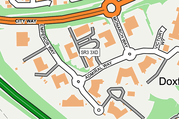
SR3 3XD is located in the Doxford electoral ward, within the metropolitan district of Sunderland and the English Parliamentary constituency of Houghton and Sunderland South. The Sub Integrated Care Board (ICB) Location is NHS North East and North Cumbria ICB - 00P and the police force is Northumbria. This postcode has been in use since June 1997.


GetTheData
Source: OS OpenMap – Local (Ordnance Survey)
Source: OS VectorMap District (Ordnance Survey)
Licence: Open Government Licence (requires attribution)
| Easting | 436132 |
| Northing | 552242 |
| Latitude | 54.863671 |
| Longitude | -1.438621 |
GetTheData
Source: Open Postcode Geo
Licence: Open Government Licence
| Country | England |
| Postcode District | SR3 |
| ➜ SR3 open data dashboard ➜ See where SR3 is on a map ➜ Where is Sunderland? | |
GetTheData
Source: Land Registry Price Paid Data
Licence: Open Government Licence
Elevation or altitude of SR3 3XD as distance above sea level:
| Metres | Feet | |
|---|---|---|
| Elevation | 100m | 328ft |
Elevation is measured from the approximate centre of the postcode, to the nearest point on an OS contour line from OS Terrain 50, which has contour spacing of ten vertical metres.
➜ How high above sea level am I? Find the elevation of your current position using your device's GPS.
GetTheData
Source: Open Postcode Elevation
Licence: Open Government Licence
| Ward | Doxford |
| Constituency | Houghton And Sunderland South |
GetTheData
Source: ONS Postcode Database
Licence: Open Government Licence
| November 2023 | Vehicle crime | On or near Briardene Close | 418m |
| November 2022 | Violence and sexual offences | On or near Briardene Close | 418m |
| June 2022 | Robbery | On or near Bus/Coach Station | 326m |
| ➜ Get more crime data in our Crime section | |||
GetTheData
Source: data.police.uk
Licence: Open Government Licence
| Doxford International (Admiral Way) | Doxford Park | 38m |
| Doxford International (Emperor Way) | Doxford Park | 138m |
| Doxford International (Monarch Avenue) | Doxford Park | 139m |
| Doxford International (Monarch Avenue) | Doxford Park | 152m |
| Doxford International-arriva (Monarch Avenue) | Doxford Park | 242m |
| Sunderland Station | 5.9km |
GetTheData
Source: NaPTAN
Licence: Open Government Licence
GetTheData
Source: ONS Postcode Database
Licence: Open Government Licence


➜ Get more ratings from the Food Standards Agency
GetTheData
Source: Food Standards Agency
Licence: FSA terms & conditions
| Last Collection | |||
|---|---|---|---|
| Location | Mon-Fri | Sat | Distance |
| Monarch Avenue | 17:30 | 12:00 | 95m |
| Woodside | 17:00 | 10:30 | 623m |
| Marcross Drive | 17:30 | 12:00 | 855m |
GetTheData
Source: Dracos
Licence: Creative Commons Attribution-ShareAlike
| Facility | Distance |
|---|---|
| David Lloyd (Sunderland) Camberwell Way, Doxford International Business Park, Sunderland Sports Hall, Swimming Pool, Health and Fitness Gym, Indoor Tennis Centre, Studio, Squash Courts, Outdoor Tennis Courts | 522m |
| Benedict Biscop Ce Academy Marcross Drive, Sunderland Grass Pitches | 833m |
| East Herrington Primary Academy Balmoral Terrace, East Herrington, Sunderland Grass Pitches | 874m |
GetTheData
Source: Active Places
Licence: Open Government Licence
| School | Phase of Education | Distance |
|---|---|---|
| Benedict Biscop Church of England Academy Marcross Drive, Moorside, Sunderland, SR3 2RE | Primary | 830m |
| East Herrington Primary Academy Balmoral Terrace, East Herrington, Sunderland, SR3 3PR | Primary | 850m |
| Farringdon Community Academy Allendale Road, Sunderland, SR3 3EL | Secondary | 1.3km |
GetTheData
Source: Edubase
Licence: Open Government Licence
The below table lists the International Territorial Level (ITL) codes (formerly Nomenclature of Territorial Units for Statistics (NUTS) codes) and Local Administrative Units (LAU) codes for SR3 3XD:
| ITL 1 Code | Name |
|---|---|
| TLC | North East (England) |
| ITL 2 Code | Name |
| TLC2 | Northumberland, and Tyne and Wear |
| ITL 3 Code | Name |
| TLC23 | Sunderland |
| LAU 1 Code | Name |
| E08000024 | Sunderland |
GetTheData
Source: ONS Postcode Directory
Licence: Open Government Licence
The below table lists the Census Output Area (OA), Lower Layer Super Output Area (LSOA), and Middle Layer Super Output Area (MSOA) for SR3 3XD:
| Code | Name | |
|---|---|---|
| OA | E00044558 | |
| LSOA | E01008775 | Sunderland 029C |
| MSOA | E02001819 | Sunderland 029 |
GetTheData
Source: ONS Postcode Directory
Licence: Open Government Licence
| SR3 3SE | Long Meadows | 267m |
| SR3 3RE | Meadow View | 320m |
| SR3 3RY | Glendale Close | 320m |
| SR3 3RG | Broadmeadows | 336m |
| SR3 3RX | Ashton Way | 363m |
| SR3 3RD | Meadow Drive | 415m |
| SR3 3SB | Long Meadows | 427m |
| SR3 3RU | Briardene Close | 444m |
| SR3 3SQ | Cranborne | 459m |
| SR3 3RB | Broadmeadows | 477m |
GetTheData
Source: Open Postcode Geo; Land Registry Price Paid Data
Licence: Open Government Licence