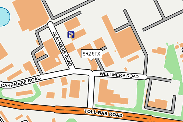
SR2 9TX lies on Claymere Road in Leechmere Industrial Estate, Sunderland. SR2 9TX is located in the Ryhope electoral ward, within the metropolitan district of Sunderland and the English Parliamentary constituency of Sunderland Central. The Sub Integrated Care Board (ICB) Location is NHS North East and North Cumbria ICB - 00P and the police force is Northumbria. This postcode has been in use since March 2010.


GetTheData
Source: OS OpenMap – Local (Ordnance Survey)
Source: OS VectorMap District (Ordnance Survey)
Licence: Open Government Licence (requires attribution)
| Easting | 440507 |
| Northing | 554061 |
| Latitude | 54.879681 |
| Longitude | -1.370211 |
GetTheData
Source: Open Postcode Geo
Licence: Open Government Licence
| Street | Claymere Road |
| Locality | Leechmere Industrial Estate |
| Town/City | Sunderland |
| Country | England |
| Postcode District | SR2 |
| ➜ SR2 open data dashboard ➜ See where SR2 is on a map ➜ Where is Sunderland? | |
GetTheData
Source: Land Registry Price Paid Data
Licence: Open Government Licence
Elevation or altitude of SR2 9TX as distance above sea level:
| Metres | Feet | |
|---|---|---|
| Elevation | 40m | 131ft |
Elevation is measured from the approximate centre of the postcode, to the nearest point on an OS contour line from OS Terrain 50, which has contour spacing of ten vertical metres.
➜ How high above sea level am I? Find the elevation of your current position using your device's GPS.
GetTheData
Source: Open Postcode Elevation
Licence: Open Government Licence
| Ward | Ryhope |
| Constituency | Sunderland Central |
GetTheData
Source: ONS Postcode Database
Licence: Open Government Licence
| July 2023 | Violence and sexual offences | On or near Whitemere Close | 426m |
| July 2023 | Other theft | On or near Whitemere Close | 426m |
| November 2022 | Violence and sexual offences | On or near Whitemere Close | 426m |
| ➜ Claymere Road crime map and outcomes | |||
GetTheData
Source: data.police.uk
Licence: Open Government Licence
| Carrmere Road-claymere Road (Carrmere Road) | Grangetown | 54m |
| Carrmere Road-claymere Road (Carrmere Road) | Grangetown | 91m |
| Carrmere Road-sandmere Road (Carrmere Road) | Grangetown | 423m |
| Leechmere Asda (Leechmere Road) | Grangetown | 437m |
| Leechmere Road-asda (Leechmere Road) | Grangetown | 445m |
| Sunderland Station | 3km |
| St Peters Station | 3.6km |
| Seaham Station | 4.8km |
GetTheData
Source: NaPTAN
Licence: Open Government Licence
GetTheData
Source: ONS Postcode Database
Licence: Open Government Licence


➜ Get more ratings from the Food Standards Agency
GetTheData
Source: Food Standards Agency
Licence: FSA terms & conditions
| Last Collection | |||
|---|---|---|---|
| Location | Mon-Fri | Sat | Distance |
| Tunstall Vale | 17:00 | 11:30 | 491m |
| Leechmere Road | 18:30 | 11:45 | 816m |
| Ryhope St South Post Office | 17:00 | 11:45 | 902m |
GetTheData
Source: Dracos
Licence: Creative Commons Attribution-ShareAlike
| Facility | Distance |
|---|---|
| The Gym Group (Sunderland South) Toll Bar Road, Sunderland Health and Fitness Gym | 375m |
| Ryhope Reclamation Site Leechmere Way, Sunderland Grass Pitches | 647m |
| Bodyline Health & Fitness (Ladies Only) (Closed) Ryhope Road, Sunderland Health and Fitness Gym | 730m |
GetTheData
Source: Active Places
Licence: Open Government Licence
| School | Phase of Education | Distance |
|---|---|---|
| Ryhope Infant School Academy Shaftesbury Avenue, Ryhope, Sunderland, SR2 0RT | Primary | 860m |
| Ryhope Junior School Shaftesbury Avenue, Ryhope, Ryhope Junior School, Sunderland, SR2 0RT | Primary | 860m |
| Hopespring Sunderland 10 Sea View Road West, Sunderland, Tyne and Wear, SR2 9HA | Not applicable | 945m |
GetTheData
Source: Edubase
Licence: Open Government Licence
The below table lists the International Territorial Level (ITL) codes (formerly Nomenclature of Territorial Units for Statistics (NUTS) codes) and Local Administrative Units (LAU) codes for SR2 9TX:
| ITL 1 Code | Name |
|---|---|
| TLC | North East (England) |
| ITL 2 Code | Name |
| TLC2 | Northumberland, and Tyne and Wear |
| ITL 3 Code | Name |
| TLC23 | Sunderland |
| LAU 1 Code | Name |
| E08000024 | Sunderland |
GetTheData
Source: ONS Postcode Directory
Licence: Open Government Licence
The below table lists the Census Output Area (OA), Lower Layer Super Output Area (LSOA), and Middle Layer Super Output Area (MSOA) for SR2 9TX:
| Code | Name | |
|---|---|---|
| OA | E00044596 | |
| LSOA | E01008779 | Sunderland 024C |
| MSOA | E02001814 | Sunderland 024 |
GetTheData
Source: ONS Postcode Directory
Licence: Open Government Licence
| SR2 9TE | Leechmere East Industrial Estate | 68m |
| SR2 9TS | Claymere Road | 103m |
| SR2 0DY | Edgmond Court | 265m |
| SR2 0DX | Edgmond Court | 287m |
| SR2 0EU | Lynthorpe | 310m |
| SR2 0EF | Cherrytree Square | 312m |
| SR2 0DT | Langhurst | 338m |
| SR2 9SZ | Irene Avenue | 346m |
| SR2 0EX | Lyngrove | 368m |
| SR2 9TA | Joan Avenue | 368m |
GetTheData
Source: Open Postcode Geo; Land Registry Price Paid Data
Licence: Open Government Licence