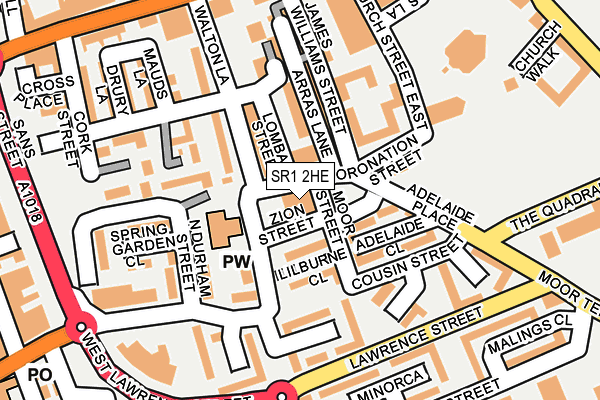
SR1 2HE is located in the Hendon electoral ward, within the metropolitan district of Sunderland and the English Parliamentary constituency of Sunderland Central. The Sub Integrated Care Board (ICB) Location is NHS North East and North Cumbria ICB - 00P and the police force is Northumbria. This postcode has been in use since February 2006.


GetTheData
Source: OS OpenMap – Local (Ordnance Survey)
Source: OS VectorMap District (Ordnance Survey)
Licence: Open Government Licence (requires attribution)
| Easting | 440430 |
| Northing | 557098 |
| Latitude | 54.906969 |
| Longitude | -1.370972 |
GetTheData
Source: Open Postcode Geo
Licence: Open Government Licence
| Country | England |
| Postcode District | SR1 |
| ➜ SR1 open data dashboard ➜ See where SR1 is on a map ➜ Where is Sunderland? | |
GetTheData
Source: Land Registry Price Paid Data
Licence: Open Government Licence
Elevation or altitude of SR1 2HE as distance above sea level:
| Metres | Feet | |
|---|---|---|
| Elevation | 20m | 66ft |
Elevation is measured from the approximate centre of the postcode, to the nearest point on an OS contour line from OS Terrain 50, which has contour spacing of ten vertical metres.
➜ How high above sea level am I? Find the elevation of your current position using your device's GPS.
GetTheData
Source: Open Postcode Elevation
Licence: Open Government Licence
| Ward | Hendon |
| Constituency | Sunderland Central |
GetTheData
Source: ONS Postcode Database
Licence: Open Government Licence
| January 2024 | Burglary | On or near Cork Street | 241m |
| December 2023 | Shoplifting | On or near Besford Grove | 259m |
| November 2023 | Criminal damage and arson | On or near Cork Street | 241m |
| ➜ Get more crime data in our Crime section | |||
GetTheData
Source: data.police.uk
Licence: Open Government Licence
| Lawrence Street | East End | 167m |
| Lawrence Street | East End | 175m |
| West Lawrence Street | East End | 225m |
| Town Moor (Moor Terrace) | East End | 232m |
| High Street East-fish Quay (High Street East) | East End | 237m |
| Sunderland (Tyne And Wear Metro Station) (Station Street) | Sunderland | 747m |
| St Peter's (Tyne And Wear Metro Station) (Sheepfolds North) | St Peter's | 960m |
| Park Lane (Tyne And Wear Metro Station) (Park Lane) | Park Lane | 1,001m |
| University (Tyne And Wear Metro Station) (A183 Chester Road) | University Of Sunderland | 1,438m |
| Stadium Of Light (Tyne And Wear Metro Station) (Millennium Way) | Sunderland Stadium Of Light | 1,468m |
| Sunderland Station | 0.7km |
| St Peters Station | 1km |
| Seaburn Station | 2.7km |
GetTheData
Source: NaPTAN
Licence: Open Government Licence
GetTheData
Source: ONS Postcode Database
Licence: Open Government Licence


➜ Get more ratings from the Food Standards Agency
GetTheData
Source: Food Standards Agency
Licence: FSA terms & conditions
| Last Collection | |||
|---|---|---|---|
| Location | Mon-Fri | Sat | Distance |
| Moor Terrace | 17:30 | 10:30 | 234m |
| High Street East | 17:30 | 10:30 | 244m |
| Hendon Road | 17:30 | 10:30 | 284m |
GetTheData
Source: Dracos
Licence: Creative Commons Attribution-ShareAlike
| Facility | Distance |
|---|---|
| Sans Street Community Centre Upper Sans Street, Sunderland Sports Hall, Studio | 215m |
| Hendon Wellbeing Hub Church Street East, Sunderland Grass Pitches | 222m |
| Hudson Road Primary School Villiers Street South, Sunderland Grass Pitches | 423m |
GetTheData
Source: Active Places
Licence: Open Government Licence
| School | Phase of Education | Distance |
|---|---|---|
| Hudson Road Primary School Villiers Street South, Sunderland, SR1 2AH | Primary | 435m |
| Dame Dorothy Primary School Dock Street, Monkwearmouth, Sunderland, SR6 0EA | Primary | 895m |
| Valley Road Academy Corporation Road, Hendon, Sunderland, SR2 8PL | Primary | 1.2km |
GetTheData
Source: Edubase
Licence: Open Government Licence
The below table lists the International Territorial Level (ITL) codes (formerly Nomenclature of Territorial Units for Statistics (NUTS) codes) and Local Administrative Units (LAU) codes for SR1 2HE:
| ITL 1 Code | Name |
|---|---|
| TLC | North East (England) |
| ITL 2 Code | Name |
| TLC2 | Northumberland, and Tyne and Wear |
| ITL 3 Code | Name |
| TLC23 | Sunderland |
| LAU 1 Code | Name |
| E08000024 | Sunderland |
GetTheData
Source: ONS Postcode Directory
Licence: Open Government Licence
The below table lists the Census Output Area (OA), Lower Layer Super Output Area (LSOA), and Middle Layer Super Output Area (MSOA) for SR1 2HE:
| Code | Name | |
|---|---|---|
| OA | E00044179 | |
| LSOA | E01008702 | Sunderland 016A |
| MSOA | E02001806 | Sunderland 016 |
GetTheData
Source: ONS Postcode Directory
Licence: Open Government Licence
| SR1 2HX | Hendon Road | 88m |
| SR1 2HB | Hendon Road | 89m |
| SR1 2JN | Adelaide Close | 100m |
| SR1 2JS | James Williams Street | 123m |
| SR1 2AP | Mauds Lane | 196m |
| SR1 2AW | Drury Lane | 209m |
| SR1 2JU | High Street East | 224m |
| SR1 2AN | Cork Street | 237m |
| SR1 2JD | Hendon Road | 243m |
| SR1 2JA | South Durham Court | 244m |
GetTheData
Source: Open Postcode Geo; Land Registry Price Paid Data
Licence: Open Government Licence