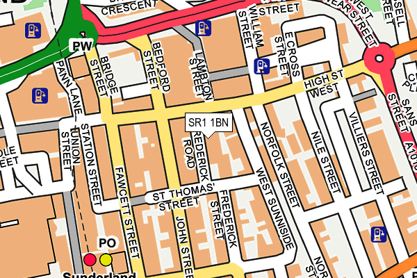
SR1 1BN is located in the Hendon electoral ward, within the metropolitan district of Sunderland and the English Parliamentary constituency of Sunderland Central. The Sub Integrated Care Board (ICB) Location is NHS North East and North Cumbria ICB - 00P and the police force is Northumbria. This postcode has been in use since January 1980.


GetTheData
Source: OS OpenMap – Local (Ordnance Survey)
Source: OS VectorMap District (Ordnance Survey)
Licence: Open Government Licence (requires attribution)
| Easting | 439865 |
| Northing | 557121 |
| Latitude | 54.907221 |
| Longitude | -1.379780 |
GetTheData
Source: Open Postcode Geo
Licence: Open Government Licence
| Country | England |
| Postcode District | SR1 |
| ➜ SR1 open data dashboard ➜ See where SR1 is on a map ➜ Where is Sunderland? | |
GetTheData
Source: Land Registry Price Paid Data
Licence: Open Government Licence
Elevation or altitude of SR1 1BN as distance above sea level:
| Metres | Feet | |
|---|---|---|
| Elevation | 30m | 98ft |
Elevation is measured from the approximate centre of the postcode, to the nearest point on an OS contour line from OS Terrain 50, which has contour spacing of ten vertical metres.
➜ How high above sea level am I? Find the elevation of your current position using your device's GPS.
GetTheData
Source: Open Postcode Elevation
Licence: Open Government Licence
| Ward | Hendon |
| Constituency | Sunderland Central |
GetTheData
Source: ONS Postcode Database
Licence: Open Government Licence
| January 2024 | Burglary | On or near Cork Street | 349m |
| December 2023 | Violence and sexual offences | On or near Athenaeum Street | 199m |
| November 2023 | Burglary | On or near Athenaeum Street | 199m |
| ➜ Get more crime data in our Crime section | |||
GetTheData
Source: data.police.uk
Licence: Open Government Licence
| John Street (John Street) | Sunderland | 50m |
| John Street (John Street) | Sunderland | 59m |
| John Street | Sunderland | 73m |
| John Street (John Street) | Sunderland | 116m |
| High Street West-frederick Road (High Street West) | Sunderland | 134m |
| Sunderland (Tyne And Wear Metro Station) (Station Street) | Sunderland | 196m |
| St Peter's (Tyne And Wear Metro Station) (Sheepfolds North) | St Peter's | 535m |
| Park Lane (Tyne And Wear Metro Station) (Park Lane) | Park Lane | 620m |
| University (Tyne And Wear Metro Station) (A183 Chester Road) | University Of Sunderland | 935m |
| Stadium Of Light (Tyne And Wear Metro Station) (Millennium Way) | Sunderland Stadium Of Light | 1,241m |
| Sunderland Station | 0.3km |
| St Peters Station | 0.5km |
| Seaburn Station | 2.5km |
GetTheData
Source: NaPTAN
Licence: Open Government Licence
GetTheData
Source: ONS Postcode Database
Licence: Open Government Licence


➜ Get more ratings from the Food Standards Agency
GetTheData
Source: Food Standards Agency
Licence: FSA terms & conditions
| Last Collection | |||
|---|---|---|---|
| Location | Mon-Fri | Sat | Distance |
| St Thomas Street | 18:15 | 12:30 | 62m |
| St Thomas Street | 64m | ||
| Bedford Street | 18:30 | 12:30 | 94m |
GetTheData
Source: Dracos
Licence: Creative Commons Attribution-ShareAlike
| Facility | Distance |
|---|---|
| O'briens Fitness Centre (Closed) St. Thomas Street, Sunderland Health and Fitness Gym, Sports Hall | 83m |
| Fit Body Fit Mind (Closed) High Street West, Sunderland Health and Fitness Gym | 95m |
| Olympia Beauty And Fitness High Street West, Sunderland Health and Fitness Gym, Studio | 385m |
GetTheData
Source: Active Places
Licence: Open Government Licence
| School | Phase of Education | Distance |
|---|---|---|
| Hudson Road Primary School Villiers Street South, Sunderland, SR1 2AH | Primary | 554m |
| University of Sunderland 4th Floor, Edinburgh Building, City Campus, Chester Road, Sunderland, SR1 3SD | Not applicable | 803m |
| Dame Dorothy Primary School Dock Street, Monkwearmouth, Sunderland, SR6 0EA | Primary | 884m |
GetTheData
Source: Edubase
Licence: Open Government Licence
The below table lists the International Territorial Level (ITL) codes (formerly Nomenclature of Territorial Units for Statistics (NUTS) codes) and Local Administrative Units (LAU) codes for SR1 1BN:
| ITL 1 Code | Name |
|---|---|
| TLC | North East (England) |
| ITL 2 Code | Name |
| TLC2 | Northumberland, and Tyne and Wear |
| ITL 3 Code | Name |
| TLC23 | Sunderland |
| LAU 1 Code | Name |
| E08000024 | Sunderland |
GetTheData
Source: ONS Postcode Directory
Licence: Open Government Licence
The below table lists the Census Output Area (OA), Lower Layer Super Output Area (LSOA), and Middle Layer Super Output Area (MSOA) for SR1 1BN:
| Code | Name | |
|---|---|---|
| OA | E00170234 | |
| LSOA | E01008703 | Sunderland 013B |
| MSOA | E02001803 | Sunderland 013 |
GetTheData
Source: ONS Postcode Directory
Licence: Open Government Licence
| SR1 1UE | Frederick Road | 33m |
| SR1 1BA | West Sunniside | 38m |
| SR1 1UB | High Street West | 65m |
| SR1 1BL | St Thomas Street | 68m |
| SR1 1TR | 76m | |
| SR1 1BH | West Sunniside | 81m |
| SR1 1TP | Lambton Street | 89m |
| SR1 1UL | William Street | 89m |
| SR1 1TZ | High Street West | 91m |
| SR1 1UG | High Street West | 94m |
GetTheData
Source: Open Postcode Geo; Land Registry Price Paid Data
Licence: Open Government Licence