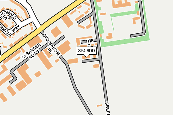
SP4 6DD lies on South Side in Old Sarum, Salisbury. SP4 6DD is located in the Old Sarum & Lower Bourne Valley electoral ward, within the unitary authority of Wiltshire and the English Parliamentary constituency of Salisbury. The Sub Integrated Care Board (ICB) Location is NHS Bath and North East Somerset, Swindon and Wiltshire ICB - 92 and the police force is Wiltshire. This postcode has been in use since January 1980.


GetTheData
Source: OS OpenMap – Local (Ordnance Survey)
Source: OS VectorMap District (Ordnance Survey)
Licence: Open Government Licence (requires attribution)
| Easting | 415603 |
| Northing | 133701 |
| Latitude | 51.102401 |
| Longitude | -1.778532 |
GetTheData
Source: Open Postcode Geo
Licence: Open Government Licence
| Street | South Side |
| Locality | Old Sarum |
| Town/City | Salisbury |
| Country | England |
| Postcode District | SP4 |
| ➜ SP4 open data dashboard ➜ See where SP4 is on a map ➜ Where is Old Sarum? | |
GetTheData
Source: Land Registry Price Paid Data
Licence: Open Government Licence
Elevation or altitude of SP4 6DD as distance above sea level:
| Metres | Feet | |
|---|---|---|
| Elevation | 70m | 230ft |
Elevation is measured from the approximate centre of the postcode, to the nearest point on an OS contour line from OS Terrain 50, which has contour spacing of ten vertical metres.
➜ How high above sea level am I? Find the elevation of your current position using your device's GPS.
GetTheData
Source: Open Postcode Elevation
Licence: Open Government Licence
| Ward | Old Sarum & Lower Bourne Valley |
| Constituency | Salisbury |
GetTheData
Source: ONS Postcode Database
Licence: Open Government Licence
| June 2022 | Anti-social behaviour | On or near Northside | 139m |
| June 2022 | Anti-social behaviour | On or near Partridge Way | 465m |
| June 2022 | Criminal damage and arson | On or near Lancaster Road | 482m |
| ➜ Get more crime data in our Crime section | |||
GetTheData
Source: data.police.uk
Licence: Open Government Licence
| Ottons Landrover (Portway) | Old Sarum | 199m |
| Green Lane (Portway) | Old Sarum | 205m |
| Ottons Landrover (Portway) | Old Sarum | 207m |
| Hatts Depot (Lysander Way) | Old Sarum | 231m |
| Herman Way (Sherbourne Drive) | Old Sarum | 273m |
| Salisbury Station | 4km |
GetTheData
Source: NaPTAN
Licence: Open Government Licence
| Percentage of properties with Next Generation Access | 100.0% |
| Percentage of properties with Superfast Broadband | 100.0% |
| Percentage of properties with Ultrafast Broadband | 0.0% |
| Percentage of properties with Full Fibre Broadband | 0.0% |
Superfast Broadband is between 30Mbps and 300Mbps
Ultrafast Broadband is > 300Mbps
| Percentage of properties unable to receive 2Mbps | 0.0% |
| Percentage of properties unable to receive 5Mbps | 0.0% |
| Percentage of properties unable to receive 10Mbps | 0.0% |
| Percentage of properties unable to receive 30Mbps | 0.0% |
GetTheData
Source: Ofcom
Licence: Ofcom Terms of Use (requires attribution)
GetTheData
Source: ONS Postcode Database
Licence: Open Government Licence


➜ Get more ratings from the Food Standards Agency
GetTheData
Source: Food Standards Agency
Licence: FSA terms & conditions
| Last Collection | |||
|---|---|---|---|
| Location | Mon-Fri | Sat | Distance |
| Old Sarum | 17:30 | 07:00 | 418m |
| Ford | 16:00 | 10:00 | 1,090m |
| Hurdcott | 17:30 | 10:00 | 1,516m |
GetTheData
Source: Dracos
Licence: Creative Commons Attribution-ShareAlike
| Facility | Distance |
|---|---|
| Salisbury Fc Partridge Way, Old Sarum, Salisbury Grass Pitches | 569m |
| Greentrees Primary School (Junior Site) Saunders Avenue, Bishopdown, Salisbury Grass Pitches | 1.1km |
| Greentrees Primary School (Infant Site) Sycamore Drive, Bishopdown, Salisbury Grass Pitches | 1.5km |
GetTheData
Source: Active Places
Licence: Open Government Licence
| School | Phase of Education | Distance |
|---|---|---|
| Old Sarum Primary School Pheasant Drive, Old Sarum, Salisbury, SP4 6GH | Primary | 598m |
| Greentrees Primary School Sycamore Drive, Bishopdown, Salisbury, SP1 3GZ | Primary | 1.5km |
| Winterbourne Earls Church of England Primary School Summerlug, Winterbourne Earls, Salisbury, SP4 6HA | Primary | 1.8km |
GetTheData
Source: Edubase
Licence: Open Government Licence
The below table lists the International Territorial Level (ITL) codes (formerly Nomenclature of Territorial Units for Statistics (NUTS) codes) and Local Administrative Units (LAU) codes for SP4 6DD:
| ITL 1 Code | Name |
|---|---|
| TLK | South West (England) |
| ITL 2 Code | Name |
| TLK1 | Gloucestershire, Wiltshire and Bath/Bristol area |
| ITL 3 Code | Name |
| TLK15 | Wiltshire |
| LAU 1 Code | Name |
| E06000054 | Wiltshire |
GetTheData
Source: ONS Postcode Directory
Licence: Open Government Licence
The below table lists the Census Output Area (OA), Lower Layer Super Output Area (LSOA), and Middle Layer Super Output Area (MSOA) for SP4 6DD:
| Code | Name | |
|---|---|---|
| OA | E00166384 | |
| LSOA | E01032011 | Wiltshire 057B |
| MSOA | E02006672 | Wiltshire 057 |
GetTheData
Source: ONS Postcode Directory
Licence: Open Government Licence
| SP4 6BN | Green Lane | 37m |
| SP4 6DB | The Close | 42m |
| SP4 6EB | Old Sarum Park | 88m |
| SP4 6BZ | Northside | 144m |
| SP4 6BQ | Throgmorton Hall | 217m |
| SP4 6BU | Old Sarum Park | 242m |
| SP4 6FG | Herman Way | 297m |
| SP4 6LG | Hurricane Business Centre | 305m |
| SP4 6BX | Westside Close | 311m |
| SP4 6FU | Devonald Way | 312m |
GetTheData
Source: Open Postcode Geo; Land Registry Price Paid Data
Licence: Open Government Licence