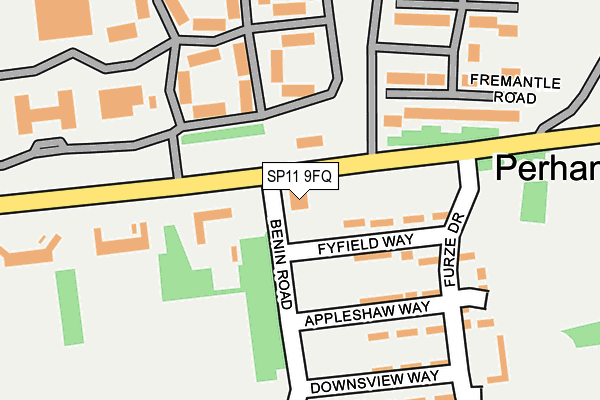
SP11 9FQ is located in the Tidworth East & Ludgershall South electoral ward, within the unitary authority of Wiltshire and the English Parliamentary constituency of Devizes. The Sub Integrated Care Board (ICB) Location is NHS Bath and North East Somerset, Swindon and Wiltshire ICB - 92 and the police force is Wiltshire. This postcode has been in use since February 2012.


GetTheData
Source: OS OpenMap – Local (Ordnance Survey)
Source: OS VectorMap District (Ordnance Survey)
Licence: Open Government Licence (requires attribution)
| Easting | 425741 |
| Northing | 148904 |
| Latitude | 51.238740 |
| Longitude | -1.632658 |
GetTheData
Source: Open Postcode Geo
Licence: Open Government Licence
| Country | England |
| Postcode District | SP11 |
| ➜ SP11 open data dashboard ➜ See where SP11 is on a map ➜ Where is Perham Down? | |
GetTheData
Source: Land Registry Price Paid Data
Licence: Open Government Licence
Elevation or altitude of SP11 9FQ as distance above sea level:
| Metres | Feet | |
|---|---|---|
| Elevation | 130m | 427ft |
Elevation is measured from the approximate centre of the postcode, to the nearest point on an OS contour line from OS Terrain 50, which has contour spacing of ten vertical metres.
➜ How high above sea level am I? Find the elevation of your current position using your device's GPS.
GetTheData
Source: Open Postcode Elevation
Licence: Open Government Licence
| Ward | Tidworth East & Ludgershall South |
| Constituency | Devizes |
GetTheData
Source: ONS Postcode Database
Licence: Open Government Licence
| June 2022 | Violence and sexual offences | On or near Fremantle Road | 185m |
| June 2022 | Other theft | On or near Meadowview Close | 221m |
| June 2022 | Other theft | On or near Meadowview Close | 221m |
| ➜ Get more crime data in our Crime section | |||
GetTheData
Source: data.police.uk
Licence: Open Government Licence
| Pre-school (Lamb Down) | Perham Down | 43m |
| Pre-school (Lamb Down) | Perham Down | 53m |
| Somme Road | Perham Down | 133m |
| Somme Road | Perham Down | 200m |
| Swinton Barracks (Lamb Down) | Perham Down | 211m |
GetTheData
Source: NaPTAN
Licence: Open Government Licence
GetTheData
Source: ONS Postcode Database
Licence: Open Government Licence


➜ Get more ratings from the Food Standards Agency
GetTheData
Source: Food Standards Agency
Licence: FSA terms & conditions
| Last Collection | |||
|---|---|---|---|
| Location | Mon-Fri | Sat | Distance |
| Perham Down Post Office | 17:15 | 11:45 | 45m |
| Tidworth Road | 17:15 | 12:00 | 1,698m |
| Station Road | 17:00 | 12:00 | 1,916m |
GetTheData
Source: Dracos
Licence: Creative Commons Attribution-ShareAlike
| Facility | Distance |
|---|---|
| Swinton Barracks Perham Down, Andover Artificial Grass Pitch, Sports Hall, Squash Courts, Grass Pitches, Outdoor Tennis Courts | 296m |
| Somme Road - Aspire Defence Ground Somme Road, Perham Down, Andover Grass Pitches | 703m |
| Tedworth Park Polo Club (Andover Site) Somme Road, Perham Down Grass Pitches | 840m |
GetTheData
Source: Active Places
Licence: Open Government Licence
| School | Phase of Education | Distance |
|---|---|---|
| The Wellington Academy Tidworth Road, Ludgershall, SP11 9RR | Secondary | 1.4km |
| Wellington Eagles Primary Academy Wellesley Road, Ludgershall, Andover, SP11 9LT | Primary | 1.5km |
| Clarendon Junior School (Clarendon Federation) Ordnance Road, Tidworth, SP9 7QD | Primary | 1.9km |
GetTheData
Source: Edubase
Licence: Open Government Licence
The below table lists the International Territorial Level (ITL) codes (formerly Nomenclature of Territorial Units for Statistics (NUTS) codes) and Local Administrative Units (LAU) codes for SP11 9FQ:
| ITL 1 Code | Name |
|---|---|
| TLK | South West (England) |
| ITL 2 Code | Name |
| TLK1 | Gloucestershire, Wiltshire and Bath/Bristol area |
| ITL 3 Code | Name |
| TLK15 | Wiltshire |
| LAU 1 Code | Name |
| E06000054 | Wiltshire |
GetTheData
Source: ONS Postcode Directory
Licence: Open Government Licence
The below table lists the Census Output Area (OA), Lower Layer Super Output Area (LSOA), and Middle Layer Super Output Area (MSOA) for SP11 9FQ:
| Code | Name | |
|---|---|---|
| OA | E00166424 | |
| LSOA | E01031878 | Wiltshire 041C |
| MSOA | E02006643 | Wiltshire 041 |
GetTheData
Source: ONS Postcode Directory
Licence: Open Government Licence
| SP11 9JZ | Fyfield Way | 90m |
| SP11 9JU | Appleshaw Way | 144m |
| SP11 9JY | Adams Close | 165m |
| SP11 9JT | The Warren | 168m |
| SP11 9JJ | Furze Drive | 203m |
| SP11 9JR | Downsview Way | 225m |
| SP11 9JX | Meadowview Close | 254m |
| SP9 7PG | Ash Close | 1404m |
| SP11 9RW | Stable Close | 1407m |
| SP9 7PQ | Oak Close | 1418m |
GetTheData
Source: Open Postcode Geo; Land Registry Price Paid Data
Licence: Open Government Licence