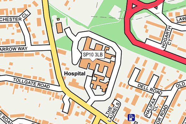
SP10 3LB is located in the Andover Harroway electoral ward, within the local authority district of Test Valley and the English Parliamentary constituency of North West Hampshire. The Sub Integrated Care Board (ICB) Location is NHS Hampshire and Isle of Wight ICB - D9Y0V and the police force is Hampshire. This postcode has been in use since January 1980.


GetTheData
Source: OS OpenMap – Local (Ordnance Survey)
Source: OS VectorMap District (Ordnance Survey)
Licence: Open Government Licence (requires attribution)
| Easting | 435390 |
| Northing | 146403 |
| Latitude | 51.215737 |
| Longitude | -1.494692 |
GetTheData
Source: Open Postcode Geo
Licence: Open Government Licence
| Country | England |
| Postcode District | SP10 |
| ➜ SP10 open data dashboard ➜ See where SP10 is on a map ➜ Where is Andover? | |
GetTheData
Source: Land Registry Price Paid Data
Licence: Open Government Licence
Elevation or altitude of SP10 3LB as distance above sea level:
| Metres | Feet | |
|---|---|---|
| Elevation | 70m | 230ft |
Elevation is measured from the approximate centre of the postcode, to the nearest point on an OS contour line from OS Terrain 50, which has contour spacing of ten vertical metres.
➜ How high above sea level am I? Find the elevation of your current position using your device's GPS.
GetTheData
Source: Open Postcode Elevation
Licence: Open Government Licence
| Ward | Andover Harroway |
| Constituency | North West Hampshire |
GetTheData
Source: ONS Postcode Database
Licence: Open Government Licence
| January 2024 | Violence and sexual offences | On or near Stubbs Court | 396m |
| January 2024 | Violence and sexual offences | On or near Stubbs Court | 396m |
| January 2024 | Vehicle crime | On or near Stubbs Court | 396m |
| ➜ Get more crime data in our Crime section | |||
GetTheData
Source: data.police.uk
Licence: Open Government Licence
| War Memorial Hospital (Charlton Road) | Andover | 150m |
| War Memorial Hospital (Charlton Road) | Andover | 158m |
| Charlton Road (Tollgate Road) | Andover | 187m |
| Parkview Close (Charlton Road) | Charlton | 287m |
| Parkview Close (Charlton Road) | Charlton | 292m |
| Andover Station | 0.5km |
GetTheData
Source: NaPTAN
Licence: Open Government Licence
GetTheData
Source: ONS Postcode Database
Licence: Open Government Licence


➜ Get more ratings from the Food Standards Agency
GetTheData
Source: Food Standards Agency
Licence: FSA terms & conditions
| Last Collection | |||
|---|---|---|---|
| Location | Mon-Fri | Sat | Distance |
| Mylen Road | 17:30 | 12:15 | 201m |
| Charlton Post Office | 18:30 | 12:15 | 466m |
| Andover Station | 18:30 | 12:00 | 496m |
GetTheData
Source: Dracos
Licence: Creative Commons Attribution-ShareAlike
| Facility | Distance |
|---|---|
| Harrow Way Community School Harrow Way, Andover Sports Hall, Grass Pitches | 476m |
| King George Road Playing Field King George Road, Andover Grass Pitches | 672m |
| Charlton Lakeside Charlton, Andover Golf | 879m |
GetTheData
Source: Active Places
Licence: Open Government Licence
| School | Phase of Education | Distance |
|---|---|---|
| Harrow Way Community School Harrow Way, Andover, SP10 3RH | Secondary | 476m |
| Rookwood School Weyhill Road, Andover, SP10 3AL | Not applicable | 1km |
| Portway Junior School Upper Drove, Andover, SP10 3NA | Primary | 1.1km |
GetTheData
Source: Edubase
Licence: Open Government Licence
The below table lists the International Territorial Level (ITL) codes (formerly Nomenclature of Territorial Units for Statistics (NUTS) codes) and Local Administrative Units (LAU) codes for SP10 3LB:
| ITL 1 Code | Name |
|---|---|
| TLJ | South East (England) |
| ITL 2 Code | Name |
| TLJ3 | Hampshire and Isle of Wight |
| ITL 3 Code | Name |
| TLJ36 | Central Hampshire |
| LAU 1 Code | Name |
| E07000093 | Test Valley |
GetTheData
Source: ONS Postcode Directory
Licence: Open Government Licence
The below table lists the Census Output Area (OA), Lower Layer Super Output Area (LSOA), and Middle Layer Super Output Area (MSOA) for SP10 3LB:
| Code | Name | |
|---|---|---|
| OA | E00117786 | |
| LSOA | E01023183 | Test Valley 004B |
| MSOA | E02004817 | Test Valley 004 |
GetTheData
Source: ONS Postcode Directory
Licence: Open Government Licence
| SP10 3UZ | Brooks Rise | 96m |
| SP10 3JX | Nestor Close | 126m |
| SP10 3LA | Charlton Road | 141m |
| SP10 3JT | Dell Road | 163m |
| SP10 3LQ | Charlton Road | 165m |
| SP10 3LE | Thistledown Close | 167m |
| SP10 3XB | Charlton Road | 173m |
| SP10 3JU | Lancaster Close | 189m |
| SP10 3JY | Charlton Road | 203m |
| SP10 3PY | Hogarth Court | 206m |
GetTheData
Source: Open Postcode Geo; Land Registry Price Paid Data
Licence: Open Government Licence