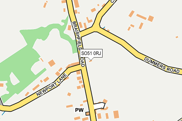
SO51 0RJ is located in the Ampfield & Braishfield electoral ward, within the local authority district of Test Valley and the English Parliamentary constituency of Romsey and Southampton North. The Sub Integrated Care Board (ICB) Location is NHS Hampshire and Isle of Wight ICB - D9Y0V and the police force is Hampshire. This postcode has been in use since June 2000.


GetTheData
Source: OS OpenMap – Local (Ordnance Survey)
Source: OS VectorMap District (Ordnance Survey)
Licence: Open Government Licence (requires attribution)
| Easting | 437532 |
| Northing | 125145 |
| Latitude | 51.024456 |
| Longitude | -1.466232 |
GetTheData
Source: Open Postcode Geo
Licence: Open Government Licence
| Country | England |
| Postcode District | SO51 |
| ➜ SO51 open data dashboard ➜ See where SO51 is on a map ➜ Where is Braishfield? | |
GetTheData
Source: Land Registry Price Paid Data
Licence: Open Government Licence
Elevation or altitude of SO51 0RJ as distance above sea level:
| Metres | Feet | |
|---|---|---|
| Elevation | 40m | 131ft |
Elevation is measured from the approximate centre of the postcode, to the nearest point on an OS contour line from OS Terrain 50, which has contour spacing of ten vertical metres.
➜ How high above sea level am I? Find the elevation of your current position using your device's GPS.
GetTheData
Source: Open Postcode Elevation
Licence: Open Government Licence
| Ward | Ampfield & Braishfield |
| Constituency | Romsey And Southampton North |
GetTheData
Source: ONS Postcode Database
Licence: Open Government Licence
| June 2023 | Other theft | On or near Hill View Road | 262m |
| June 2022 | Other theft | On or near Blackthorn Close | 151m |
| June 2022 | Vehicle crime | On or near Hill View Road | 262m |
| ➜ Get more crime data in our Crime section | |||
GetTheData
Source: data.police.uk
Licence: Open Government Licence
| War Memorial (Braishfield Road) | Braishfield | 76m |
| War Memorial (Braishfield Road) | Braishfield | 86m |
| The Wheatsheaf Inn (Braishfield Road) | Braishfield | 318m |
| The Wheatsheaf Inn (Braishfield Road) | Braishfield | 384m |
| Dog And Crook (Braishfield Road) | Braishfield | 947m |
| Romsey Station | 4km |
GetTheData
Source: NaPTAN
Licence: Open Government Licence
GetTheData
Source: ONS Postcode Database
Licence: Open Government Licence


➜ Get more ratings from the Food Standards Agency
GetTheData
Source: Food Standards Agency
Licence: FSA terms & conditions
| Last Collection | |||
|---|---|---|---|
| Location | Mon-Fri | Sat | Distance |
| The Straight Mile | 16:45 | 08:00 | 2,409m |
| Woodley | 16:45 | 08:00 | 2,552m |
| Great Woodley P.o. | 17:15 | 11:45 | 2,854m |
GetTheData
Source: Dracos
Licence: Creative Commons Attribution-ShareAlike
| Facility | Distance |
|---|---|
| Braishfield Recreation Ground Braishfield, Romsey Grass Pitches | 242m |
| Braishfield Cricket Club Dummers Road, Braishfield, Romsey Grass Pitches | 294m |
| Ganger Farm Sports Park Ganger Farm Way, Ampfield, Romsey Grass Pitches, Artificial Grass Pitch, Studio | 1.9km |
GetTheData
Source: Active Places
Licence: Open Government Licence
| School | Phase of Education | Distance |
|---|---|---|
| Braishfield Primary School Common Hill Road, Braishfield, Romsey, SO51 0QF | Primary | 368m |
| Cupernham Infant School Bransley Close, Woodley Lane, Romsey, SO51 7JT | Primary | 3km |
| Cupernham Junior School Bransley Close, Romsey, SO51 7JT | Primary | 3km |
GetTheData
Source: Edubase
Licence: Open Government Licence
The below table lists the International Territorial Level (ITL) codes (formerly Nomenclature of Territorial Units for Statistics (NUTS) codes) and Local Administrative Units (LAU) codes for SO51 0RJ:
| ITL 1 Code | Name |
|---|---|
| TLJ | South East (England) |
| ITL 2 Code | Name |
| TLJ3 | Hampshire and Isle of Wight |
| ITL 3 Code | Name |
| TLJ36 | Central Hampshire |
| LAU 1 Code | Name |
| E07000093 | Test Valley |
GetTheData
Source: ONS Postcode Directory
Licence: Open Government Licence
The below table lists the Census Output Area (OA), Lower Layer Super Output Area (LSOA), and Middle Layer Super Output Area (MSOA) for SO51 0RJ:
| Code | Name | |
|---|---|---|
| OA | E00117658 | |
| LSOA | E01023158 | Test Valley 012A |
| MSOA | E02004825 | Test Valley 012 |
GetTheData
Source: ONS Postcode Directory
Licence: Open Government Licence
| SO51 0PN | Braishfield Road | 133m |
| SO51 0PX | Blackthorn Close | 164m |
| SO51 0PL | Newport Lane | 197m |
| SO51 0PQ | Braishfield Road | 213m |
| SO51 0PP | Hill View Road | 279m |
| SO51 0QF | Common Hill Road | 320m |
| SO51 0QH | Church Lane | 338m |
| SO51 0PR | Braishfield Road | 516m |
| SO51 0QE | Braishfield Road | 719m |
| SO51 0PJ | Kiln Lane | 771m |
GetTheData
Source: Open Postcode Geo; Land Registry Price Paid Data
Licence: Open Government Licence