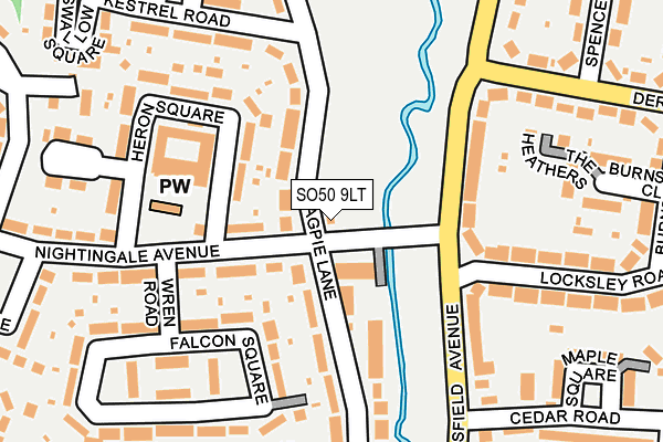
SO50 9LT is located in the Eastleigh South electoral ward, within the local authority district of Eastleigh and the English Parliamentary constituency of Eastleigh. The Sub Integrated Care Board (ICB) Location is NHS Hampshire and Isle of Wight ICB - D9Y0V and the police force is Hampshire. This postcode has been in use since December 1994.


GetTheData
Source: OS OpenMap – Local (Ordnance Survey)
Source: OS VectorMap District (Ordnance Survey)
Licence: Open Government Licence (requires attribution)
| Easting | 444194 |
| Northing | 118452 |
| Latitude | 50.963794 |
| Longitude | -1.372051 |
GetTheData
Source: Open Postcode Geo
Licence: Open Government Licence
| Country | England |
| Postcode District | SO50 |
| ➜ SO50 open data dashboard ➜ See where SO50 is on a map ➜ Where is Eastleigh? | |
GetTheData
Source: Land Registry Price Paid Data
Licence: Open Government Licence
Elevation or altitude of SO50 9LT as distance above sea level:
| Metres | Feet | |
|---|---|---|
| Elevation | 10m | 33ft |
Elevation is measured from the approximate centre of the postcode, to the nearest point on an OS contour line from OS Terrain 50, which has contour spacing of ten vertical metres.
➜ How high above sea level am I? Find the elevation of your current position using your device's GPS.
GetTheData
Source: Open Postcode Elevation
Licence: Open Government Licence
| Ward | Eastleigh South |
| Constituency | Eastleigh |
GetTheData
Source: ONS Postcode Database
Licence: Open Government Licence
| January 2024 | Violence and sexual offences | On or near Starling Square | 223m |
| January 2024 | Violence and sexual offences | On or near Woodpecker Way | 358m |
| December 2023 | Violence and sexual offences | On or near Starling Square | 223m |
| ➜ Get more crime data in our Crime section | |||
GetTheData
Source: data.police.uk
Licence: Open Government Licence
| Nightingale Bridge (Magpie Lane) | Eastleigh | 29m |
| Nightingale Bridge (Nightingale Avenue) | Eastleigh | 76m |
| Cedar Road | Eastleigh | 160m |
| Cedar Road (Passfield Avenue) | Eastleigh | 174m |
| Spencer Road (Derby Road) | Eastleigh | 222m |
| Southampton Airport Parkway Station | 1.6km |
| Eastleigh Station | 1.7km |
| Chandlers Ford Station | 2.4km |
GetTheData
Source: NaPTAN
Licence: Open Government Licence
| Percentage of properties with Next Generation Access | 100.0% |
| Percentage of properties with Superfast Broadband | 100.0% |
| Percentage of properties with Ultrafast Broadband | 100.0% |
| Percentage of properties with Full Fibre Broadband | 0.0% |
Superfast Broadband is between 30Mbps and 300Mbps
Ultrafast Broadband is > 300Mbps
| Percentage of properties unable to receive 2Mbps | 0.0% |
| Percentage of properties unable to receive 5Mbps | 0.0% |
| Percentage of properties unable to receive 10Mbps | 0.0% |
| Percentage of properties unable to receive 30Mbps | 0.0% |
GetTheData
Source: Ofcom
Licence: Ofcom Terms of Use (requires attribution)
GetTheData
Source: ONS Postcode Database
Licence: Open Government Licence


➜ Get more ratings from the Food Standards Agency
GetTheData
Source: Food Standards Agency
Licence: FSA terms & conditions
| Last Collection | |||
|---|---|---|---|
| Location | Mon-Fri | Sat | Distance |
| Heron Square | 17:30 | 11:45 | 144m |
| Chestnut Avenue | 16:15 | 11:45 | 316m |
| Passfield Avenue Post Office | 17:15 | 12:00 | 418m |
GetTheData
Source: Dracos
Licence: Creative Commons Attribution-ShareAlike
| Facility | Distance |
|---|---|
| Monksbrook (Closed) Stoneham Lane, Eastleigh Grass Pitches | 371m |
| Pavilion On The Park Kingfisher Road, Eastleigh Sports Hall | 387m |
| Barton Peveril Sixth Form College Chestnut Avenue, Eastleigh Sports Hall, Grass Pitches, Health and Fitness Gym, Studio, Outdoor Tennis Courts | 440m |
GetTheData
Source: Active Places
Licence: Open Government Licence
| School | Phase of Education | Distance |
|---|---|---|
| Barton Peveril Sixth Form College Chestnut Avenue, Eastleigh, SO50 5ZA | 16 plus | 441m |
| Nightingale Primary School Blackbird Road, Eastleigh, SO50 9JW | Primary | 607m |
| Stoneham Park Primary Academy 21 Whieldon Way, North Stoneham Park, Eastleigh, SO50 9SB | Primary | 849m |
GetTheData
Source: Edubase
Licence: Open Government Licence
The below table lists the International Territorial Level (ITL) codes (formerly Nomenclature of Territorial Units for Statistics (NUTS) codes) and Local Administrative Units (LAU) codes for SO50 9LT:
| ITL 1 Code | Name |
|---|---|
| TLJ | South East (England) |
| ITL 2 Code | Name |
| TLJ3 | Hampshire and Isle of Wight |
| ITL 3 Code | Name |
| TLJ35 | South Hampshire |
| LAU 1 Code | Name |
| E07000086 | Eastleigh |
GetTheData
Source: ONS Postcode Directory
Licence: Open Government Licence
The below table lists the Census Output Area (OA), Lower Layer Super Output Area (LSOA), and Middle Layer Super Output Area (MSOA) for SO50 9LT:
| Code | Name | |
|---|---|---|
| OA | E00115279 | |
| LSOA | E01022678 | Eastleigh 006C |
| MSOA | E02004717 | Eastleigh 006 |
GetTheData
Source: ONS Postcode Directory
Licence: Open Government Licence
| SO50 9PY | Nightingale Avenue | 50m |
| SO50 9LU | Magpie Lane | 74m |
| SO50 9JA | Nightingale Avenue | 127m |
| SO50 9NE | Passfield Avenue | 134m |
| SO50 9JD | Heron Square | 147m |
| SO50 9LS | Magpie Lane | 150m |
| SO50 9LR | Magpie Lane | 160m |
| SO50 9ND | Passfield Avenue | 167m |
| SO50 5JZ | The Heathers | 194m |
| SO50 9LN | Kestrel Road | 198m |
GetTheData
Source: Open Postcode Geo; Land Registry Price Paid Data
Licence: Open Government Licence