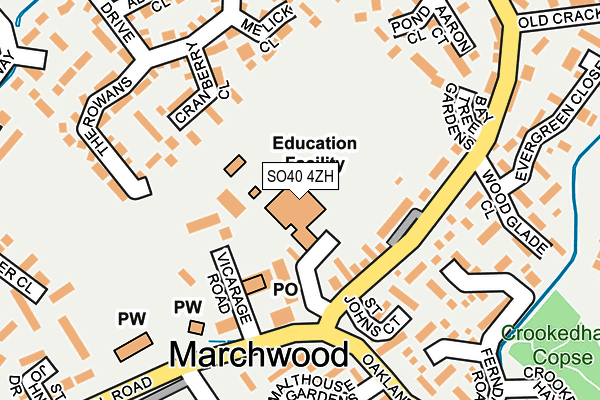
SO40 4ZH is located in the Marchwood & Eling electoral ward, within the local authority district of New Forest and the English Parliamentary constituency of New Forest East. The Sub Integrated Care Board (ICB) Location is NHS Hampshire and Isle of Wight ICB - D9Y0V and the police force is Hampshire. This postcode has been in use since December 1994.


GetTheData
Source: OS OpenMap – Local (Ordnance Survey)
Source: OS VectorMap District (Ordnance Survey)
Licence: Open Government Licence (requires attribution)
| Easting | 438728 |
| Northing | 110366 |
| Latitude | 50.891486 |
| Longitude | -1.450748 |
GetTheData
Source: Open Postcode Geo
Licence: Open Government Licence
| Country | England |
| Postcode District | SO40 |
➜ See where SO40 is on a map ➜ Where is Marchwood? | |
GetTheData
Source: Land Registry Price Paid Data
Licence: Open Government Licence
Elevation or altitude of SO40 4ZH as distance above sea level:
| Metres | Feet | |
|---|---|---|
| Elevation | 10m | 33ft |
Elevation is measured from the approximate centre of the postcode, to the nearest point on an OS contour line from OS Terrain 50, which has contour spacing of ten vertical metres.
➜ How high above sea level am I? Find the elevation of your current position using your device's GPS.
GetTheData
Source: Open Postcode Elevation
Licence: Open Government Licence
| Ward | Marchwood & Eling |
| Constituency | New Forest East |
GetTheData
Source: ONS Postcode Database
Licence: Open Government Licence
| The White Horse (Main Road) | Marchwood | 153m |
| St Johns Church (Main Road) | Marchwood | 175m |
| St Johns Church (Main Road) | Marchwood | 250m |
| Ferndale Road (Oakland Drive) | Marchwood | 280m |
| The White Horse (Main Road) | Marchwood | 282m |
| Millbrook (Hants) Station | 2.5km |
| Southampton Central Station | 3.2km |
| Southampton Town Quay | 3.2km |
GetTheData
Source: NaPTAN
Licence: Open Government Licence
GetTheData
Source: ONS Postcode Database
Licence: Open Government Licence


➜ Get more ratings from the Food Standards Agency
GetTheData
Source: Food Standards Agency
Licence: FSA terms & conditions
| Last Collection | |||
|---|---|---|---|
| Location | Mon-Fri | Sat | Distance |
| Marchwood Post Office | 16:45 | 09:30 | 94m |
| Main Road | 16:45 | 09:30 | 247m |
| Marchwood Industrial Estate | 16:45 | 09:30 | 547m |
GetTheData
Source: Dracos
Licence: Creative Commons Attribution-ShareAlike
The below table lists the International Territorial Level (ITL) codes (formerly Nomenclature of Territorial Units for Statistics (NUTS) codes) and Local Administrative Units (LAU) codes for SO40 4ZH:
| ITL 1 Code | Name |
|---|---|
| TLJ | South East (England) |
| ITL 2 Code | Name |
| TLJ3 | Hampshire and Isle of Wight |
| ITL 3 Code | Name |
| TLJ36 | Central Hampshire |
| LAU 1 Code | Name |
| E07000091 | New Forest |
GetTheData
Source: ONS Postcode Directory
Licence: Open Government Licence
The below table lists the Census Output Area (OA), Lower Layer Super Output Area (LSOA), and Middle Layer Super Output Area (MSOA) for SO40 4ZH:
| Code | Name | |
|---|---|---|
| OA | E00117115 | |
| LSOA | E01023047 | New Forest 008C |
| MSOA | E02004786 | New Forest 008 |
GetTheData
Source: ONS Postcode Directory
Licence: Open Government Licence
| SO40 4SF | Marchwood Village Centre | 78m |
| SO40 4UZ | Main Road | 89m |
| SO40 4SX | Village Mews | 133m |
| SO40 4YT | Cranberry Close | 158m |
| SO40 4SG | Main Road | 168m |
| SO40 4YJ | Melick Close | 169m |
| SO40 4YU | Pond Close | 186m |
| SO40 4YW | The Rowans | 200m |
| SO40 4XT | Woodglade Close | 200m |
| SO40 4XR | Ferndale Road | 203m |
GetTheData
Source: Open Postcode Geo; Land Registry Price Paid Data
Licence: Open Government Licence