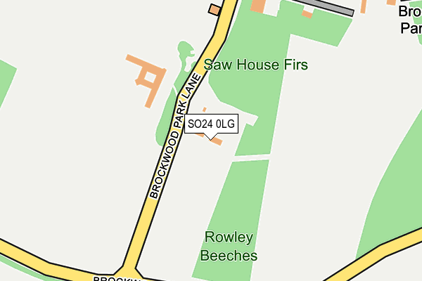
SO24 0LG is located in the Upper Meon Valley electoral ward, within the local authority district of Winchester and the English Parliamentary constituency of Meon Valley. The Sub Integrated Care Board (ICB) Location is NHS Hampshire and Isle of Wight ICB - D9Y0V and the police force is Hampshire. This postcode has been in use since January 1980.


GetTheData
Source: OS OpenMap – Local (Ordnance Survey)
Source: OS VectorMap District (Ordnance Survey)
Licence: Open Government Licence (requires attribution)
| Easting | 462663 |
| Northing | 126156 |
| Latitude | 51.031355 |
| Longitude | -1.107754 |
GetTheData
Source: Open Postcode Geo
Licence: Open Government Licence
| Country | England |
| Postcode District | SO24 |
| ➜ SO24 open data dashboard ➜ See where SO24 is on a map | |
GetTheData
Source: Land Registry Price Paid Data
Licence: Open Government Licence
Elevation or altitude of SO24 0LG as distance above sea level:
| Metres | Feet | |
|---|---|---|
| Elevation | 130m | 427ft |
Elevation is measured from the approximate centre of the postcode, to the nearest point on an OS contour line from OS Terrain 50, which has contour spacing of ten vertical metres.
➜ How high above sea level am I? Find the elevation of your current position using your device's GPS.
GetTheData
Source: Open Postcode Elevation
Licence: Open Government Licence
| Ward | Upper Meon Valley |
| Constituency | Meon Valley |
GetTheData
Source: ONS Postcode Database
Licence: Open Government Licence
| Brockwood Turn (A272 Winchester Road) | West Meon Woodlands | 1,026m |
| The Dean (A272 Winchester Road) | West Meon Woodlands | 1,032m |
| Brockwood Turn (A272 Winchester Road) | West Meon Woodlands | 1,036m |
| The Dean (A272 Winchester Road) | West Meon Woodlands | 1,039m |
| Lowlands Farm (A272 Winchester Road) | West Meon Woodlands | 1,253m |
GetTheData
Source: NaPTAN
Licence: Open Government Licence
| Percentage of properties with Next Generation Access | 0.0% |
| Percentage of properties with Superfast Broadband | 0.0% |
| Percentage of properties with Ultrafast Broadband | 0.0% |
| Percentage of properties with Full Fibre Broadband | 0.0% |
Superfast Broadband is between 30Mbps and 300Mbps
Ultrafast Broadband is > 300Mbps
| Percentage of properties unable to receive 2Mbps | 0.0% |
| Percentage of properties unable to receive 5Mbps | 0.0% |
| Percentage of properties unable to receive 10Mbps | 100.0% |
| Percentage of properties unable to receive 30Mbps | 100.0% |
GetTheData
Source: Ofcom
Licence: Ofcom Terms of Use (requires attribution)
GetTheData
Source: ONS Postcode Database
Licence: Open Government Licence


➜ Get more ratings from the Food Standards Agency
GetTheData
Source: Food Standards Agency
Licence: FSA terms & conditions
| Last Collection | |||
|---|---|---|---|
| Location | Mon-Fri | Sat | Distance |
| Woodlands | 16:15 | 09:15 | 2,172m |
| Long Priors | 16:00 | 08:00 | 2,190m |
| The Hut (X Roads) | 16:00 | 09:30 | 2,275m |
GetTheData
Source: Dracos
Licence: Creative Commons Attribution-ShareAlike
| Facility | Distance |
|---|---|
| Brockwood Park School Brockwood, Bramdean, Alresford Swimming Pool, Grass Pitches, Outdoor Tennis Courts, Sports Hall | 306m |
| West Meon Sports Ground Headon View, West Meon Grass Pitches, Outdoor Tennis Courts | 2.3km |
| Cheriton Recreation Ground Brandy Mount, Cheriton Grass Pitches, Outdoor Tennis Courts | 5.1km |
GetTheData
Source: Active Places
Licence: Open Government Licence
| School | Phase of Education | Distance |
|---|---|---|
| Brockwood Park School Brockwood Park, Bramdean, Alresford, SO24 0LQ | Not applicable | 302m |
| West Meon Church of England Voluntary Controlled Primary School Church Lane, West Meon, Petersfield, GU32 1LF | Primary | 2.4km |
| Cheriton Primary School Cheriton, Alresford, SO24 0QA | Primary | 4.9km |
GetTheData
Source: Edubase
Licence: Open Government Licence
The below table lists the International Territorial Level (ITL) codes (formerly Nomenclature of Territorial Units for Statistics (NUTS) codes) and Local Administrative Units (LAU) codes for SO24 0LG:
| ITL 1 Code | Name |
|---|---|
| TLJ | South East (England) |
| ITL 2 Code | Name |
| TLJ3 | Hampshire and Isle of Wight |
| ITL 3 Code | Name |
| TLJ36 | Central Hampshire |
| LAU 1 Code | Name |
| E07000094 | Winchester |
GetTheData
Source: ONS Postcode Directory
Licence: Open Government Licence
The below table lists the Census Output Area (OA), Lower Layer Super Output Area (LSOA), and Middle Layer Super Output Area (MSOA) for SO24 0LG:
| Code | Name | |
|---|---|---|
| OA | E00118000 | |
| LSOA | E01023225 | Winchester 004A |
| MSOA | E02004832 | Winchester 004 |
GetTheData
Source: ONS Postcode Directory
Licence: Open Government Licence
| SO24 0LQ | Brockwood | 290m |
| SO24 0LJ | Brockwood Dean Cottages | 986m |
| GU32 1JP | 1142m | |
| GU32 1JS | 1408m | |
| SO24 0LL | 1652m | |
| GU32 1JW | Lippen Cottages | 1801m |
| SO24 0LR | Woodcote Cottages | 1969m |
| SO24 0LP | Fox Lane | 1995m |
| SO24 0LN | 2003m | |
| SO24 0HW | 2085m |
GetTheData
Source: Open Postcode Geo; Land Registry Price Paid Data
Licence: Open Government Licence