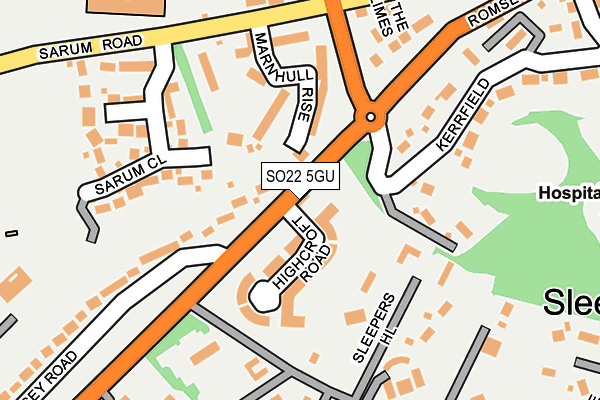
SO22 5GU lies on Highcroft Road in Winchester. SO22 5GU is located in the St Paul electoral ward, within the local authority district of Winchester and the English Parliamentary constituency of Winchester. The Sub Integrated Care Board (ICB) Location is NHS Hampshire and Isle of Wight ICB - D9Y0V and the police force is Hampshire. This postcode has been in use since December 2009.


GetTheData
Source: OS OpenMap – Local (Ordnance Survey)
Source: OS VectorMap District (Ordnance Survey)
Licence: Open Government Licence (requires attribution)
| Easting | 446502 |
| Northing | 129119 |
| Latitude | 51.059535 |
| Longitude | -1.337834 |
GetTheData
Source: Open Postcode Geo
Licence: Open Government Licence
| Street | Highcroft Road |
| Town/City | Winchester |
| Country | England |
| Postcode District | SO22 |
| ➜ SO22 open data dashboard ➜ See where SO22 is on a map ➜ Where is Winchester? | |
GetTheData
Source: Land Registry Price Paid Data
Licence: Open Government Licence
Elevation or altitude of SO22 5GU as distance above sea level:
| Metres | Feet | |
|---|---|---|
| Elevation | 120m | 394ft |
Elevation is measured from the approximate centre of the postcode, to the nearest point on an OS contour line from OS Terrain 50, which has contour spacing of ten vertical metres.
➜ How high above sea level am I? Find the elevation of your current position using your device's GPS.
GetTheData
Source: Open Postcode Elevation
Licence: Open Government Licence
| Ward | St Paul |
| Constituency | Winchester |
GetTheData
Source: ONS Postcode Database
Licence: Open Government Licence
| November 2023 | Criminal damage and arson | On or near Wilberforce Close | 412m |
| October 2023 | Criminal damage and arson | On or near Wilberforce Close | 412m |
| August 2023 | Violence and sexual offences | On or near Wilberforce Close | 412m |
| ➜ Highcroft Road crime map and outcomes | |||
GetTheData
Source: data.police.uk
Licence: Open Government Licence
| Sleepers Hill (Romsey Road) | Sleepers Hill | 188m |
| Sleepers Hill (Romsey Road) | Sleepers Hill | 240m |
| Cornes Close (Greenhill Road) | Fulflood | 352m |
| Cornes Close (Greenhill Road) | Fulflood | 359m |
| Thurmond Road (Thurmond Crescent) | Stanmore | 362m |
| Winchester Station | 1.5km |
| Shawford Station | 4.2km |
GetTheData
Source: NaPTAN
Licence: Open Government Licence
Estimated total energy consumption in SO22 5GU by fuel type, 2015.
| Consumption (kWh) | 89,220 |
|---|---|
| Meter count | 34 |
| Mean (kWh/meter) | 2,624 |
| Median (kWh/meter) | 2,318 |
GetTheData
Source: Postcode level gas estimates: 2015 (experimental)
Source: Postcode level electricity estimates: 2015 (experimental)
Licence: Open Government Licence
GetTheData
Source: ONS Postcode Database
Licence: Open Government Licence


➜ Get more ratings from the Food Standards Agency
GetTheData
Source: Food Standards Agency
Licence: FSA terms & conditions
| Last Collection | |||
|---|---|---|---|
| Location | Mon-Fri | Sat | Distance |
| Highcroft | 17:15 | 11:30 | 147m |
| Milverton Road | 16:15 | 11:00 | 748m |
| St James Lane | 17:30 | 11:15 | 769m |
GetTheData
Source: Dracos
Licence: Creative Commons Attribution-ShareAlike
| Facility | Distance |
|---|---|
| Kings School Sports Centre Romsey Road, Winchester Sports Hall, Swimming Pool, Health and Fitness Gym, Artificial Grass Pitch, Grass Pitches, Studio, Outdoor Tennis Courts | 627m |
| University Of Winchester Sparkford Road, Winchester Sports Hall, Health and Fitness Gym, Squash Courts, Studio, Outdoor Tennis Courts | 779m |
| Royal Winchester Golf Club Sarum Road, Winchester Golf | 867m |
GetTheData
Source: Active Places
Licence: Open Government Licence
| School | Phase of Education | Distance |
|---|---|---|
| Kings' School Romsey Road, Winchester, SO22 5PN | Secondary | 613m |
| University of Winchester Sparkford Road, Winchester, SO22 4NR | Not applicable | 766m |
| Western Church of England Primary School Browning Drive, Winchester, SO22 5AR | Primary | 845m |
GetTheData
Source: Edubase
Licence: Open Government Licence
The below table lists the International Territorial Level (ITL) codes (formerly Nomenclature of Territorial Units for Statistics (NUTS) codes) and Local Administrative Units (LAU) codes for SO22 5GU:
| ITL 1 Code | Name |
|---|---|
| TLJ | South East (England) |
| ITL 2 Code | Name |
| TLJ3 | Hampshire and Isle of Wight |
| ITL 3 Code | Name |
| TLJ36 | Central Hampshire |
| LAU 1 Code | Name |
| E07000094 | Winchester |
GetTheData
Source: ONS Postcode Directory
Licence: Open Government Licence
The below table lists the Census Output Area (OA), Lower Layer Super Output Area (LSOA), and Middle Layer Super Output Area (MSOA) for SO22 5GU:
| Code | Name | |
|---|---|---|
| OA | E00118201 | |
| LSOA | E01023263 | Winchester 007C |
| MSOA | E02004835 | Winchester 007 |
GetTheData
Source: ONS Postcode Directory
Licence: Open Government Licence
| SO22 5GH | Highcroft Road | 33m |
| SO22 5GT | Highcroft Road | 46m |
| SO22 5GS | Highcroft Road | 73m |
| SO22 5GJ | Highcroft Road | 82m |
| SO22 5GP | Highcroft Road | 100m |
| SO22 5FH | Marnhull Rise | 106m |
| SO22 5GR | Royal Crescent | 120m |
| SO22 5GQ | Highcroft Road | 120m |
| SO22 5HA | Sarum Road | 159m |
| SO22 5FA | Marnhull Rise | 160m |
GetTheData
Source: Open Postcode Geo; Land Registry Price Paid Data
Licence: Open Government Licence