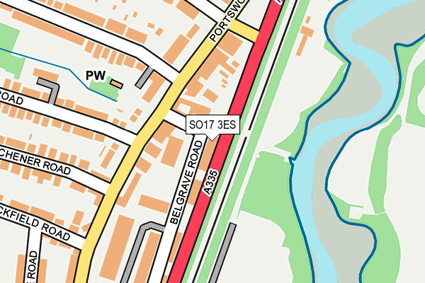
SO17 3ES is located in the Swaythling electoral ward, within the unitary authority of Southampton and the English Parliamentary constituency of Romsey and Southampton North. The Sub Integrated Care Board (ICB) Location is NHS Hampshire and Isle of Wight ICB - D9Y0V and the police force is Hampshire. This postcode has been in use since July 2003.


GetTheData
Source: OS OpenMap – Local (Ordnance Survey)
Source: OS VectorMap District (Ordnance Survey)
Licence: Open Government Licence (requires attribution)
| Easting | 443492 |
| Northing | 114983 |
| Latitude | 50.932654 |
| Longitude | -1.382461 |
GetTheData
Source: Open Postcode Geo
Licence: Open Government Licence
| Country | England |
| Postcode District | SO17 |
| ➜ SO17 open data dashboard ➜ See where SO17 is on a map ➜ Where is Southampton? | |
GetTheData
Source: Land Registry Price Paid Data
Licence: Open Government Licence
Elevation or altitude of SO17 3ES as distance above sea level:
| Metres | Feet | |
|---|---|---|
| Elevation | 10m | 33ft |
Elevation is measured from the approximate centre of the postcode, to the nearest point on an OS contour line from OS Terrain 50, which has contour spacing of ten vertical metres.
➜ How high above sea level am I? Find the elevation of your current position using your device's GPS.
GetTheData
Source: Open Postcode Elevation
Licence: Open Government Licence
| Ward | Swaythling |
| Constituency | Romsey And Southampton North |
GetTheData
Source: ONS Postcode Database
Licence: Open Government Licence
| June 2022 | Violence and sexual offences | On or near Nightclub | 62m |
| June 2022 | Anti-social behaviour | On or near Nightclub | 62m |
| June 2022 | Criminal damage and arson | On or near Nightclub | 62m |
| ➜ Get more crime data in our Crime section | |||
GetTheData
Source: data.police.uk
Licence: Open Government Licence
| Sirdar Road (Portswood Road) | Swaythling | 95m |
| Sirdar Road (Portswood Road) | Swaythling | 100m |
| Mayfield Road (Portswood Road) | Swaythling | 138m |
| Mayfield Road (Portswood Road) | Swaythling | 213m |
| Langhorn Road (Portswood Road) | Swaythling | 367m |
| Swaythling Station | 1km |
| St Denys Station | 1.2km |
| Bitterne Station | 1.7km |
GetTheData
Source: NaPTAN
Licence: Open Government Licence
GetTheData
Source: ONS Postcode Database
Licence: Open Government Licence

➜ Get more ratings from the Food Standards Agency
GetTheData
Source: Food Standards Agency
Licence: FSA terms & conditions
| Last Collection | |||
|---|---|---|---|
| Location | Mon-Fri | Sat | Distance |
| Portswood Road Post Office | 18:30 | 12:00 | 114m |
| Bowden Lane | 16:00 | 11:15 | 352m |
| Woodmill Lane | 16:00 | 12:00 | 539m |
GetTheData
Source: Dracos
Licence: Creative Commons Attribution-ShareAlike
| Facility | Distance |
|---|---|
| Portswood Recreation Ground Upper Grosvenor Road, Southampton Outdoor Tennis Courts | 502m |
| Bitterne Park Primary School Manor Farm Road, Southampton Grass Pitches | 516m |
| Riverside Park (Southampton) Manor Farm Road, Southampton Grass Pitches, Outdoor Tennis Courts | 621m |
GetTheData
Source: Active Places
Licence: Open Government Licence
| School | Phase of Education | Distance |
|---|---|---|
| Portswood Primary School Somerset Road, Southampton, SO17 3AA | Primary | 431m |
| Bitterne Park Primary School Manor Farm Road, Bitterne Park, Southampton, SO18 1NX | Primary | 521m |
| Swaythling Primary School Mayfield Road, Southampton, SO17 3SZ | Primary | 686m |
GetTheData
Source: Edubase
Licence: Open Government Licence
The below table lists the International Territorial Level (ITL) codes (formerly Nomenclature of Territorial Units for Statistics (NUTS) codes) and Local Administrative Units (LAU) codes for SO17 3ES:
| ITL 1 Code | Name |
|---|---|
| TLJ | South East (England) |
| ITL 2 Code | Name |
| TLJ3 | Hampshire and Isle of Wight |
| ITL 3 Code | Name |
| TLJ32 | Southampton |
| LAU 1 Code | Name |
| E06000045 | Southampton |
GetTheData
Source: ONS Postcode Directory
Licence: Open Government Licence
The below table lists the Census Output Area (OA), Lower Layer Super Output Area (LSOA), and Middle Layer Super Output Area (MSOA) for SO17 3ES:
| Code | Name | |
|---|---|---|
| OA | E00087218 | |
| LSOA | E01032756 | Southampton 005F |
| MSOA | E02003553 | Southampton 005 |
GetTheData
Source: ONS Postcode Directory
Licence: Open Government Licence
| SO17 3SD | Portswood Road | 89m |
| SO17 3SP | Portswood Road | 102m |
| SO17 3SL | Portswood Road | 154m |
| SO17 3SQ | Portswood Road | 162m |
| SO17 3SE | Portswood Road | 175m |
| SO17 3AF | Brickfield Road | 264m |
| SO17 3SB | Portswood Road | 276m |
| SO17 3AE | Brickfield Road | 287m |
| SO17 3SA | Portswood Road | 289m |
| SO17 3SF | Kitchener Road | 297m |
GetTheData
Source: Open Postcode Geo; Land Registry Price Paid Data
Licence: Open Government Licence