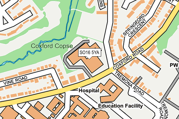
SO16 5YA is located in the Coxford electoral ward, within the unitary authority of Southampton and the English Parliamentary constituency of Southampton, Test. The Sub Integrated Care Board (ICB) Location is NHS Hampshire and Isle of Wight ICB - D9Y0V and the police force is Hampshire. This postcode has been in use since December 1994.


GetTheData
Source: OS OpenMap – Local (Ordnance Survey)
Source: OS VectorMap District (Ordnance Survey)
Licence: Open Government Licence (requires attribution)
| Easting | 439808 |
| Northing | 115242 |
| Latitude | 50.935257 |
| Longitude | -1.434863 |
GetTheData
Source: Open Postcode Geo
Licence: Open Government Licence
| Country | England |
| Postcode District | SO16 |
| ➜ SO16 open data dashboard ➜ See where SO16 is on a map ➜ Where is Southampton? | |
GetTheData
Source: Land Registry Price Paid Data
Licence: Open Government Licence
Elevation or altitude of SO16 5YA as distance above sea level:
| Metres | Feet | |
|---|---|---|
| Elevation | 30m | 98ft |
Elevation is measured from the approximate centre of the postcode, to the nearest point on an OS contour line from OS Terrain 50, which has contour spacing of ten vertical metres.
➜ How high above sea level am I? Find the elevation of your current position using your device's GPS.
GetTheData
Source: Open Postcode Elevation
Licence: Open Government Licence
| Ward | Coxford |
| Constituency | Southampton, Test |
GetTheData
Source: ONS Postcode Database
Licence: Open Government Licence
| December 2023 | Vehicle crime | On or near Laundry Road | 427m |
| December 2023 | Public order | On or near Laundry Road | 427m |
| October 2023 | Violence and sexual offences | On or near Laundry Road | 427m |
| ➜ Get more crime data in our Crime section | |||
GetTheData
Source: data.police.uk
Licence: Open Government Licence
| General Hospital (Coxford Road) | Shirley Warren | 64m |
| General Hospital (Coxford Road) | Shirley Warren | 99m |
| General Hospital And Cemetery (Tremona Road) | Southampton General | 138m |
| General Hospital (Unamed Private Road) | Southampton General | 156m |
| Vine Road (Coxford Road) | Southampton General | 224m |
| Millbrook (Hants) Station | 2.6km |
| Redbridge (Hants) Station | 3km |
| Southampton Central Station | 3.4km |
GetTheData
Source: NaPTAN
Licence: Open Government Licence
GetTheData
Source: ONS Postcode Database
Licence: Open Government Licence


➜ Get more ratings from the Food Standards Agency
GetTheData
Source: Food Standards Agency
Licence: FSA terms & conditions
| Last Collection | |||
|---|---|---|---|
| Location | Mon-Fri | Sat | Distance |
| General Hospital | 17:30 | 12:00 | 198m |
| Dale Valley Road(84) | 17:30 | 11:30 | 491m |
| Coxford Road | 16:45 | 12:15 | 499m |
GetTheData
Source: Dracos
Licence: Creative Commons Attribution-ShareAlike
| Facility | Distance |
|---|---|
| Coxford Community Centre (Closed) Olive Road, Southampton Sports Hall | 447m |
| Olive Road Open Space (Closed) Olive Road, Southampton Grass Pitches | 473m |
| Puregym (Southampton Shirley) Winchester Road, Southampton Swimming Pool, Health and Fitness Gym, Studio | 897m |
GetTheData
Source: Active Places
Licence: Open Government Licence
| School | Phase of Education | Distance |
|---|---|---|
| Southampton Hospital School 119 Tremona Road, Southampton, SO16 6HU | Not applicable | 498m |
| Rosewood Free School Aldermoor Road, Southampton, SO16 5NA | Not applicable | 613m |
| Shirley Warren Primary & Nursery School Warren Crescent, Southampton, SO16 6AY | Primary | 761m |
GetTheData
Source: Edubase
Licence: Open Government Licence
The below table lists the International Territorial Level (ITL) codes (formerly Nomenclature of Territorial Units for Statistics (NUTS) codes) and Local Administrative Units (LAU) codes for SO16 5YA:
| ITL 1 Code | Name |
|---|---|
| TLJ | South East (England) |
| ITL 2 Code | Name |
| TLJ3 | Hampshire and Isle of Wight |
| ITL 3 Code | Name |
| TLJ32 | Southampton |
| LAU 1 Code | Name |
| E06000045 | Southampton |
GetTheData
Source: ONS Postcode Directory
Licence: Open Government Licence
The below table lists the Census Output Area (OA), Lower Layer Super Output Area (LSOA), and Middle Layer Super Output Area (MSOA) for SO16 5YA:
| Code | Name | |
|---|---|---|
| OA | E00086803 | |
| LSOA | E01017187 | Southampton 002E |
| MSOA | E02003550 | Southampton 002 |
GetTheData
Source: ONS Postcode Directory
Licence: Open Government Licence
| SO16 5AR | Coxford Road | 65m |
| SO16 5AQ | Coxford Road | 90m |
| SO16 5LB | Coxford Road | 99m |
| SO16 5LJ | Coxford Road | 111m |
| SO16 5TD | Vine Road | 177m |
| SO16 5HX | Springford Road | 180m |
| SO16 5LA | Coxford Road | 185m |
| SO16 5LF | Springford Crescent | 197m |
| SO16 5JZ | Arcadia Close | 212m |
| SO16 6HW | Tremona Road | 226m |
GetTheData
Source: Open Postcode Geo; Land Registry Price Paid Data
Licence: Open Government Licence