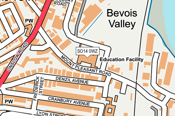
SO14 0WZ is located in the Bevois electoral ward, within the unitary authority of Southampton and the English Parliamentary constituency of Southampton, Test. The Sub Integrated Care Board (ICB) Location is NHS Hampshire and Isle of Wight ICB - D9Y0V and the police force is Hampshire. This postcode has been in use since December 1994.


GetTheData
Source: OS OpenMap – Local (Ordnance Survey)
Source: OS VectorMap District (Ordnance Survey)
Licence: Open Government Licence (requires attribution)
| Easting | 442704 |
| Northing | 113029 |
| Latitude | 50.915152 |
| Longitude | -1.393911 |
GetTheData
Source: Open Postcode Geo
Licence: Open Government Licence
| Country | England |
| Postcode District | SO14 |
| ➜ SO14 open data dashboard ➜ See where SO14 is on a map ➜ Where is Southampton? | |
GetTheData
Source: Land Registry Price Paid Data
Licence: Open Government Licence
Elevation or altitude of SO14 0WZ as distance above sea level:
| Metres | Feet | |
|---|---|---|
| Elevation | 10m | 33ft |
Elevation is measured from the approximate centre of the postcode, to the nearest point on an OS contour line from OS Terrain 50, which has contour spacing of ten vertical metres.
➜ How high above sea level am I? Find the elevation of your current position using your device's GPS.
GetTheData
Source: Open Postcode Elevation
Licence: Open Government Licence
| Ward | Bevois |
| Constituency | Southampton, Test |
GetTheData
Source: ONS Postcode Database
Licence: Open Government Licence
| January 2024 | Violence and sexual offences | On or near Hospital | 379m |
| January 2024 | Vehicle crime | On or near Liverpool Street | 485m |
| January 2024 | Vehicle crime | On or near Cedar Road | 493m |
| ➜ Get more crime data in our Crime section | |||
GetTheData
Source: data.police.uk
Licence: Open Government Licence
| Aldi Store (Bevois Valley Road) | Bevois Valley | 235m |
| Denzil Avenue (Onslow Road) | Bevois Valley | 263m |
| Royal South Hants Hospital (The Grounds) | Nicholstown | 313m |
| Aldi Store (Bevois Valley Road) | Bevois Valley | 317m |
| Denzil Avenue (Onslow Road) | Bevois Valley | 367m |
| St Denys Station | 0.9km |
| Bitterne Station | 1.2km |
| Southampton Central Station | 1.6km |
GetTheData
Source: NaPTAN
Licence: Open Government Licence
GetTheData
Source: ONS Postcode Database
Licence: Open Government Licence


➜ Get more ratings from the Food Standards Agency
GetTheData
Source: Food Standards Agency
Licence: FSA terms & conditions
| Last Collection | |||
|---|---|---|---|
| Location | Mon-Fri | Sat | Distance |
| Derby Road | 17:30 | 11:30 | 168m |
| Onslow Road | 17:30 | 11:30 | 216m |
| Bevois Valley | 17:30 | 11:15 | 221m |
GetTheData
Source: Dracos
Licence: Creative Commons Attribution-ShareAlike
| Facility | Distance |
|---|---|
| Mount Pleasant Junior School Mount Pleasant Road, Southampton Artificial Grass Pitch | 0m |
| Newtown Youth & Community Centre Graham Road, Southampton Health and Fitness Gym, Sports Hall, Artificial Grass Pitch | 446m |
| Bevois Town Primary School Cedar Road, Southampton Artificial Grass Pitch | 538m |
GetTheData
Source: Active Places
Licence: Open Government Licence
| School | Phase of Education | Distance |
|---|---|---|
| Mount Pleasant Junior School Mount Pleasant Road, Southampton, SO14 0WZ | Primary | 0m |
| Maytree Nursery and Infants' School Derby Road, Southampton, SO14 0DY | Primary | 192m |
| Bevois Town Primary School Cedar Road, Southampton, SO14 6RU | Primary | 538m |
GetTheData
Source: Edubase
Licence: Open Government Licence
The below table lists the International Territorial Level (ITL) codes (formerly Nomenclature of Territorial Units for Statistics (NUTS) codes) and Local Administrative Units (LAU) codes for SO14 0WZ:
| ITL 1 Code | Name |
|---|---|
| TLJ | South East (England) |
| ITL 2 Code | Name |
| TLJ3 | Hampshire and Isle of Wight |
| ITL 3 Code | Name |
| TLJ32 | Southampton |
| LAU 1 Code | Name |
| E06000045 | Southampton |
GetTheData
Source: ONS Postcode Directory
Licence: Open Government Licence
The below table lists the Census Output Area (OA), Lower Layer Super Output Area (LSOA), and Middle Layer Super Output Area (MSOA) for SO14 0WZ:
| Code | Name | |
|---|---|---|
| OA | E00086632 | |
| LSOA | E01017155 | Southampton 022C |
| MSOA | E02003570 | Southampton 022 |
GetTheData
Source: ONS Postcode Directory
Licence: Open Government Licence
| SO14 0EF | Mount Pleasant Road | 80m |
| SO14 0LN | Denzil Avenue | 83m |
| SO14 0EA | Derby Road | 90m |
| SO14 0DZ | Derby Road | 108m |
| SO14 0LP | Denzil Avenue | 111m |
| SO14 0EB | Mount Pleasant Road | 112m |
| SO14 0LT | Cranbury Avenue | 150m |
| SO14 0EE | Blackberry Terrace | 152m |
| SO14 0ED | Blackberry Terrace | 163m |
| SO14 0JU | Empress Road | 169m |
GetTheData
Source: Open Postcode Geo; Land Registry Price Paid Data
Licence: Open Government Licence