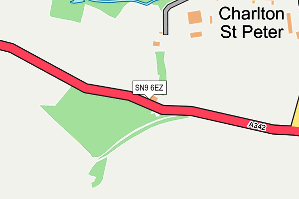
SN9 6EZ is in Charlton, Pewsey. SN9 6EZ is located in the Pewsey Vale West electoral ward, within the unitary authority of Wiltshire and the English Parliamentary constituency of Devizes. The Sub Integrated Care Board (ICB) Location is NHS Bath and North East Somerset, Swindon and Wiltshire ICB - 92 and the police force is Wiltshire. This postcode has been in use since January 1993.


GetTheData
Source: OS OpenMap – Local (Ordnance Survey)
Source: OS VectorMap District (Ordnance Survey)
Licence: Open Government Licence (requires attribution)
| Easting | 411404 |
| Northing | 155849 |
| Latitude | 51.301652 |
| Longitude | -1.837806 |
GetTheData
Source: Open Postcode Geo
Licence: Open Government Licence
| Locality | Charlton |
| Town/City | Pewsey |
| Country | England |
| Postcode District | SN9 |
| ➜ SN9 open data dashboard ➜ See where SN9 is on a map ➜ Where is Charlton St Peter? | |
GetTheData
Source: Land Registry Price Paid Data
Licence: Open Government Licence
Elevation or altitude of SN9 6EZ as distance above sea level:
| Metres | Feet | |
|---|---|---|
| Elevation | 110m | 361ft |
Elevation is measured from the approximate centre of the postcode, to the nearest point on an OS contour line from OS Terrain 50, which has contour spacing of ten vertical metres.
➜ How high above sea level am I? Find the elevation of your current position using your device's GPS.
GetTheData
Source: Open Postcode Elevation
Licence: Open Government Licence
| Ward | Pewsey Vale West |
| Constituency | Devizes |
GetTheData
Source: ONS Postcode Database
Licence: Open Government Licence
| January 2022 | Anti-social behaviour | On or near Friday Lane | 338m |
| November 2021 | Criminal damage and arson | On or near Friday Lane | 338m |
| September 2021 | Anti-social behaviour | On or near Friday Lane | 338m |
| ➜ Get more crime data in our Crime section | |||
GetTheData
Source: data.police.uk
Licence: Open Government Licence
| The Cat (Devizes Road) | Charlton | 41m |
| The Cat (Devizes Road) | Charlton | 42m |
| St Peter's Church (The Sweeney) | Charlton St Peter | 374m |
| Primary School (Pewsey Road) | Rushall | 1,029m |
| Primary School (Pewsey Road) | Rushall | 1,037m |
| Pewsey Station | 6.5km |
GetTheData
Source: NaPTAN
Licence: Open Government Licence
GetTheData
Source: ONS Postcode Database
Licence: Open Government Licence


➜ Get more ratings from the Food Standards Agency
GetTheData
Source: Food Standards Agency
Licence: FSA terms & conditions
| Last Collection | |||
|---|---|---|---|
| Location | Mon-Fri | Sat | Distance |
| Rushall | 16:30 | 09:30 | 950m |
| Upavon Post Office | 16:30 | 10:30 | 2,127m |
| Avon Square | 16:00 | 10:15 | 2,713m |
GetTheData
Source: Dracos
Licence: Creative Commons Attribution-ShareAlike
| Facility | Distance |
|---|---|
| Rushall C Of E Primary School Pewsey Road, Rushall, Pewsey Grass Pitches | 1.1km |
| Upavon Playing Fields Andover Road, Upavon, Pewsey Grass Pitches | 2.9km |
| Upavon Golf Club York Road, Upavon, Pewsey Golf | 4.1km |
GetTheData
Source: Active Places
Licence: Open Government Licence
| School | Phase of Education | Distance |
|---|---|---|
| Rushall Church of England Primary School Rushall, Pewsey, SN9 6EN | Primary | 1.1km |
| Woodborough Church of England Primary School Broad Street, Pewsey, SN9 5PL | Primary | 4.1km |
| Chirton Church of England Primary School The Street, Chirton, Devizes, SN10 3QS | Primary | 4.4km |
GetTheData
Source: Edubase
Licence: Open Government Licence
The below table lists the International Territorial Level (ITL) codes (formerly Nomenclature of Territorial Units for Statistics (NUTS) codes) and Local Administrative Units (LAU) codes for SN9 6EZ:
| ITL 1 Code | Name |
|---|---|
| TLK | South West (England) |
| ITL 2 Code | Name |
| TLK1 | Gloucestershire, Wiltshire and Bath/Bristol area |
| ITL 3 Code | Name |
| TLK15 | Wiltshire |
| LAU 1 Code | Name |
| E06000054 | Wiltshire |
GetTheData
Source: ONS Postcode Directory
Licence: Open Government Licence
The below table lists the Census Output Area (OA), Lower Layer Super Output Area (LSOA), and Middle Layer Super Output Area (MSOA) for SN9 6EZ:
| Code | Name | |
|---|---|---|
| OA | E00162614 | |
| LSOA | E01031882 | Wiltshire 038C |
| MSOA | E02006642 | Wiltshire 038 |
GetTheData
Source: ONS Postcode Directory
Licence: Open Government Licence
| SN9 6EU | 315m | |
| SN9 6EY | Friday Lane | 353m |
| SN9 6EX | Eastfield Cottages | 395m |
| SN9 6ET | Devizes Road | 968m |
| SN9 6EP | Park View | 994m |
| SN9 6EW | The Court | 1001m |
| SN9 6BF | Pewsey Road | 1008m |
| SN9 6HA | 1041m | |
| SN9 6EN | Pewsey Road | 1052m |
| SN9 6EG | 1100m |
GetTheData
Source: Open Postcode Geo; Land Registry Price Paid Data
Licence: Open Government Licence