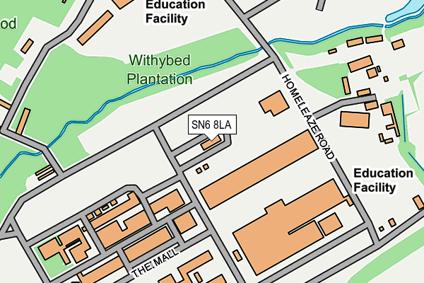
SN6 8LA is located in the Watchfield & Shrivenham electoral ward, within the local authority district of Vale of White Horse and the English Parliamentary constituency of Wantage. The Sub Integrated Care Board (ICB) Location is NHS Bath and North East Somerset, Swindon and Wiltshire ICB - 92 and the police force is Thames Valley. This postcode has been in use since January 1980.


GetTheData
Source: OS OpenMap – Local (Ordnance Survey)
Source: OS VectorMap District (Ordnance Survey)
Licence: Open Government Licence (requires attribution)
| Easting | 425464 |
| Northing | 190019 |
| Latitude | 51.608435 |
| Longitude | -1.633670 |
GetTheData
Source: Open Postcode Geo
Licence: Open Government Licence
| Country | England |
| Postcode District | SN6 |
| ➜ SN6 open data dashboard ➜ See where SN6 is on a map ➜ Where is Shrivenham? | |
GetTheData
Source: Land Registry Price Paid Data
Licence: Open Government Licence
Elevation or altitude of SN6 8LA as distance above sea level:
| Metres | Feet | |
|---|---|---|
| Elevation | 90m | 295ft |
Elevation is measured from the approximate centre of the postcode, to the nearest point on an OS contour line from OS Terrain 50, which has contour spacing of ten vertical metres.
➜ How high above sea level am I? Find the elevation of your current position using your device's GPS.
GetTheData
Source: Open Postcode Elevation
Licence: Open Government Licence
| Ward | Watchfield & Shrivenham |
| Constituency | Wantage |
GetTheData
Source: ONS Postcode Database
Licence: Open Government Licence
| May 2022 | Burglary | On or near Faringdon Road | 468m |
| April 2022 | Burglary | On or near Faringdon Road | 468m |
| ➜ Get more crime data in our Crime section | |||
GetTheData
Source: data.police.uk
Licence: Open Government Licence
| Axis Road (Faringdon Road) | Watchfield | 419m |
| Axis Road (Faringdon Road) | Watchfield | 435m |
| Military College (Faringdon Road) | Watchfield | 548m |
| Military College (Faringdon Road) | Watchfield | 578m |
| Meadow Road (Majors Road) | Watchfield | 717m |
GetTheData
Source: NaPTAN
Licence: Open Government Licence
| Median download speed | 13.3Mbps |
| Average download speed | 17.1Mbps |
| Maximum download speed | 32.10Mbps |
| Median upload speed | 0.9Mbps |
| Average upload speed | 2.0Mbps |
| Maximum upload speed | 5.18Mbps |
GetTheData
Source: Ofcom
Licence: Ofcom Terms of Use (requires attribution)
GetTheData
Source: ONS Postcode Database
Licence: Open Government Licence


➜ Get more ratings from the Food Standards Agency
GetTheData
Source: Food Standards Agency
Licence: FSA terms & conditions
| Last Collection | |||
|---|---|---|---|
| Location | Mon-Fri | Sat | Distance |
| Shrivenham Post Office | 18:30 | 12:30 | 1,820m |
| Sand Hill | 16:45 | 09:30 | 2,371m |
| Fernham | 16:45 | 07:00 | 4,244m |
GetTheData
Source: Dracos
Licence: Creative Commons Attribution-ShareAlike
| Facility | Distance |
|---|---|
| The Defence Academy (Shrivenham Station) Faringdon Road, Shrivenham, Swindon Sports Hall, Swimming Pool, Health and Fitness Gym, Golf, Squash Courts, Outdoor Tennis Courts, Artificial Grass Pitch, Grass Pitches | 463m |
| Watchfield Primary School North Street, Watchfield, Swindon Grass Pitches | 833m |
| Airey Neave Memorial Ground Majors Road, Watchfield, Swindon Grass Pitches | 1km |
GetTheData
Source: Active Places
Licence: Open Government Licence
| School | Phase of Education | Distance |
|---|---|---|
| Watchfield Primary School North Street, Watchfield, SN6 8SD | Primary | 800m |
| Shrivenham Church of England School High Street, Shrivenham, Swindon, SN6 8AA | Primary | 1.9km |
| Longcot and Fernham Church of England Primary School Kings Lane, Longcot, Faringdon, SN7 7SY | Primary | 2km |
GetTheData
Source: Edubase
Licence: Open Government Licence
The below table lists the International Territorial Level (ITL) codes (formerly Nomenclature of Territorial Units for Statistics (NUTS) codes) and Local Administrative Units (LAU) codes for SN6 8LA:
| ITL 1 Code | Name |
|---|---|
| TLJ | South East (England) |
| ITL 2 Code | Name |
| TLJ1 | Berkshire, Buckinghamshire and Oxfordshire |
| ITL 3 Code | Name |
| TLJ14 | Oxfordshire CC |
| LAU 1 Code | Name |
| E07000180 | Vale of White Horse |
GetTheData
Source: ONS Postcode Directory
Licence: Open Government Licence
The below table lists the Census Output Area (OA), Lower Layer Super Output Area (LSOA), and Middle Layer Super Output Area (MSOA) for SN6 8LA:
| Code | Name | |
|---|---|---|
| OA | E00146420 | |
| LSOA | E01028747 | Vale of White Horse 016C |
| MSOA | E02006886 | Vale of White Horse 016 |
GetTheData
Source: ONS Postcode Directory
Licence: Open Government Licence
| SN6 8SA | High Street | 765m |
| SN6 8HG | Longcot Road | 812m |
| SN6 8RT | Charlesby Drive | 837m |
| SN6 8SX | Shute Avenue | 861m |
| SN6 8SU | Barrington Road | 862m |
| SN6 8TP | The Mews | 875m |
| SN6 8SZ | High Street | 877m |
| SN6 8RS | Lapwing Lane | 895m |
| SN6 8TJ | Maidens Close | 911m |
| SN6 8SW | High Street | 934m |
GetTheData
Source: Open Postcode Geo; Land Registry Price Paid Data
Licence: Open Government Licence