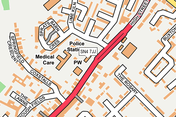
SN4 7JJ is located in the Royal Wootton Bassett North electoral ward, within the unitary authority of Wiltshire and the English Parliamentary constituency of North Wiltshire. The Sub Integrated Care Board (ICB) Location is NHS Bath and North East Somerset, Swindon and Wiltshire ICB - 92 and the police force is Wiltshire. This postcode has been in use since April 1985.


GetTheData
Source: OS OpenMap – Local (Ordnance Survey)
Source: OS VectorMap District (Ordnance Survey)
Licence: Open Government Licence (requires attribution)
| Easting | 406988 |
| Northing | 182898 |
| Latitude | 51.544935 |
| Longitude | -1.900624 |
GetTheData
Source: Open Postcode Geo
Licence: Open Government Licence
| Country | England |
| Postcode District | SN4 |
| ➜ SN4 open data dashboard ➜ See where SN4 is on a map ➜ Where is Royal Wootton Bassett? | |
GetTheData
Source: Land Registry Price Paid Data
Licence: Open Government Licence
Elevation or altitude of SN4 7JJ as distance above sea level:
| Metres | Feet | |
|---|---|---|
| Elevation | 130m | 427ft |
Elevation is measured from the approximate centre of the postcode, to the nearest point on an OS contour line from OS Terrain 50, which has contour spacing of ten vertical metres.
➜ How high above sea level am I? Find the elevation of your current position using your device's GPS.
GetTheData
Source: Open Postcode Elevation
Licence: Open Government Licence
| Ward | Royal Wootton Bassett North |
| Constituency | North Wiltshire |
GetTheData
Source: ONS Postcode Database
Licence: Open Government Licence
| January 2024 | Other crime | On or near Lime Kiln | 198m |
| January 2024 | Violence and sexual offences | On or near Lime Kiln | 198m |
| January 2024 | Shoplifting | On or near Petrol Station | 423m |
| ➜ Get more crime data in our Crime section | |||
GetTheData
Source: data.police.uk
Licence: Open Government Licence
| Police Station (Lime Kiln) | Royal Wootton Bassett | 71m |
| Police Station (Lime Kiln) | Royal Wootton Bassett | 72m |
| St Bartholemews (High Street) | Royal Wootton Bassett | 73m |
| St Bartholemews (High Street) | Royal Wootton Bassett | 118m |
| High Street | Royal Wootton Bassett | 254m |
GetTheData
Source: NaPTAN
Licence: Open Government Licence
GetTheData
Source: ONS Postcode Database
Licence: Open Government Licence


➜ Get more ratings from the Food Standards Agency
GetTheData
Source: Food Standards Agency
Licence: FSA terms & conditions
| Last Collection | |||
|---|---|---|---|
| Location | Mon-Fri | Sat | Distance |
| Wootton Bassett Post Office | 18:30 | 12:30 | 404m |
| Wootton Bassett Post Office | 18:30 | 12:30 | 418m |
| Longleaze | 16:15 | 10:15 | 449m |
GetTheData
Source: Dracos
Licence: Creative Commons Attribution-ShareAlike
| Facility | Distance |
|---|---|
| St Bartholomew's Primary Academy The Rosary, Royal Wootton Bassett, Swindon Grass Pitches | 146m |
| Lime Kiln Leisure Centre Lime Kiln, Royal Wootton Bassett, Swindon Sports Hall, Swimming Pool, Health and Fitness Gym, Studio, Squash Courts | 229m |
| Royal Wootton Bassett Academy Lime Kiln, Royal Wootton Bassett, Swindon Grass Pitches, Sports Hall, Artificial Grass Pitch | 375m |
GetTheData
Source: Active Places
Licence: Open Government Licence
| School | Phase of Education | Distance |
|---|---|---|
| St Bartholomew's Primary Academy The Rosary, Royal Wootton Bassett, SN4 8AZ | Primary | 151m |
| Royal Wootton Bassett Academy Lime Kiln, Royal Wootton Bassett, Swindon, SN4 7HG | Secondary | 374m |
| Longleaze Primary School Byron Avenue, Royal Wootton Bassett, Swindon, SN4 8BA | Primary | 484m |
GetTheData
Source: Edubase
Licence: Open Government Licence
The below table lists the International Territorial Level (ITL) codes (formerly Nomenclature of Territorial Units for Statistics (NUTS) codes) and Local Administrative Units (LAU) codes for SN4 7JJ:
| ITL 1 Code | Name |
|---|---|
| TLK | South West (England) |
| ITL 2 Code | Name |
| TLK1 | Gloucestershire, Wiltshire and Bath/Bristol area |
| ITL 3 Code | Name |
| TLK15 | Wiltshire |
| LAU 1 Code | Name |
| E06000054 | Wiltshire |
GetTheData
Source: ONS Postcode Directory
Licence: Open Government Licence
The below table lists the Census Output Area (OA), Lower Layer Super Output Area (LSOA), and Middle Layer Super Output Area (MSOA) for SN4 7JJ:
| Code | Name | |
|---|---|---|
| OA | E00163007 | |
| LSOA | E01031963 | Wiltshire 006A |
| MSOA | E02006649 | Wiltshire 006 |
GetTheData
Source: ONS Postcode Directory
Licence: Open Government Licence
| SN4 7AS | High Street | 87m |
| SN4 7AR | High Street | 110m |
| SN4 7BN | Tinkers Lane | 122m |
| SN4 7JP | Sprats Barn Crescent | 128m |
| SN4 7HG | Lime Kiln | 147m |
| SN4 8AQ | The Rosary | 151m |
| SN4 7AW | Coxstalls | 161m |
| SN4 7JR | Sprats Barn Crescent | 171m |
| SN4 7JT | Manor House Close | 181m |
| SN4 8AZ | The Rosary | 189m |
GetTheData
Source: Open Postcode Geo; Land Registry Price Paid Data
Licence: Open Government Licence