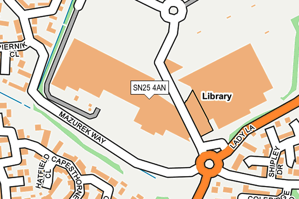
SN25 4AN is located in the Priory Vale electoral ward, within the unitary authority of Swindon and the English Parliamentary constituency of North Swindon. The Sub Integrated Care Board (ICB) Location is NHS Bath and North East Somerset, Swindon and Wiltshire ICB - 92 and the police force is Wiltshire. This postcode has been in use since December 2001.


GetTheData
Source: OS OpenMap – Local (Ordnance Survey)
Source: OS VectorMap District (Ordnance Survey)
Licence: Open Government Licence (requires attribution)
| Easting | 413440 |
| Northing | 188715 |
| Latitude | 51.597122 |
| Longitude | -1.807364 |
GetTheData
Source: Open Postcode Geo
Licence: Open Government Licence
| Country | England |
| Postcode District | SN25 |
| ➜ SN25 open data dashboard ➜ See where SN25 is on a map ➜ Where is Swindon? | |
GetTheData
Source: Land Registry Price Paid Data
Licence: Open Government Licence
Elevation or altitude of SN25 4AN as distance above sea level:
| Metres | Feet | |
|---|---|---|
| Elevation | 90m | 295ft |
Elevation is measured from the approximate centre of the postcode, to the nearest point on an OS contour line from OS Terrain 50, which has contour spacing of ten vertical metres.
➜ How high above sea level am I? Find the elevation of your current position using your device's GPS.
GetTheData
Source: Open Postcode Elevation
Licence: Open Government Licence
| Ward | Priory Vale |
| Constituency | North Swindon |
GetTheData
Source: ONS Postcode Database
Licence: Open Government Licence
| December 2023 | Shoplifting | On or near Mazurek Way | 229m |
| December 2023 | Theft from the person | On or near Mazurek Way | 229m |
| December 2023 | Shoplifting | On or near Mazurek Way | 229m |
| ➜ Get more crime data in our Crime section | |||
GetTheData
Source: data.police.uk
Licence: Open Government Licence
| Asda Walmart (Orbital Shopping Park) | Haydon Wick | 85m |
| Asda Walmart (Orbital Shopping Park) | Haydon Wick | 95m |
| Asda Walmart (Orbital Shopping Park) | Haydon Wick | 96m |
| Asda Walmart (Orbital Shopping Park) | Haydon Wick | 105m |
| Asda Walmart (Lady Lane) | Haydon Wick | 147m |
| Swindon Station | 3.8km |
GetTheData
Source: NaPTAN
Licence: Open Government Licence
GetTheData
Source: ONS Postcode Database
Licence: Open Government Licence


➜ Get more ratings from the Food Standards Agency
GetTheData
Source: Food Standards Agency
Licence: FSA terms & conditions
| Last Collection | |||
|---|---|---|---|
| Location | Mon-Fri | Sat | Distance |
| Asda(Walmart) | 18:30 | 12:15 | 138m |
| Bramdean Close | 17:30 | 12:00 | 363m |
| Shepperton Way | 17:30 | 12:00 | 626m |
GetTheData
Source: Dracos
Licence: Creative Commons Attribution-ShareAlike
| Facility | Distance |
|---|---|
| Everlast Gyms (Swindon) Thamesdown Drive, Swindon Swimming Pool, Health and Fitness Gym, Studio | 33m |
| Haydon Centre Thames Avenue, Swindon Sports Hall, Studio, Health and Fitness Gym | 491m |
| Orchid Vale Primary School Torun Way, Swindon Artificial Grass Pitch, Grass Pitches | 559m |
GetTheData
Source: Active Places
Licence: Open Government Licence
| School | Phase of Education | Distance |
|---|---|---|
| Catherine Wayte Primary School Elstree Way, Abbey Meads, Swindon, SN25 4TA | Primary | 558m |
| Orchid Vale Primary School Torun Way, Haydon End, Swindon, SN25 1UG | Primary | 562m |
| Haydonleigh Primary School Haydon Court Drive, Haydon Wick, Swindon, SN25 1JP | Primary | 570m |
GetTheData
Source: Edubase
Licence: Open Government Licence
The below table lists the International Territorial Level (ITL) codes (formerly Nomenclature of Territorial Units for Statistics (NUTS) codes) and Local Administrative Units (LAU) codes for SN25 4AN:
| ITL 1 Code | Name |
|---|---|
| TLK | South West (England) |
| ITL 2 Code | Name |
| TLK1 | Gloucestershire, Wiltshire and Bath/Bristol area |
| ITL 3 Code | Name |
| TLK14 | Swindon |
| LAU 1 Code | Name |
| E06000030 | Swindon |
GetTheData
Source: ONS Postcode Directory
Licence: Open Government Licence
The below table lists the Census Output Area (OA), Lower Layer Super Output Area (LSOA), and Middle Layer Super Output Area (MSOA) for SN25 4AN:
| Code | Name | |
|---|---|---|
| OA | E00078243 | |
| LSOA | E01032710 | Swindon 028E |
| MSOA | E02006849 | Swindon 028 |
GetTheData
Source: ONS Postcode Directory
Licence: Open Government Licence
| SN25 1UW | Osterley Road | 191m |
| SN25 1UU | Pencarrow Close | 222m |
| SN25 1UX | Chilworth Close | 252m |
| SN25 4ZA | Shipley Drive | 253m |
| SN25 1UN | Osterley Road | 255m |
| SN25 1UY | Hatfield Close | 261m |
| SN25 1UR | Capesthorne Drive | 271m |
| SN25 4FJ | Coleridge Road | 275m |
| SN25 1UP | Capesthorne Drive | 297m |
| SN25 4FN | Pope Close | 305m |
GetTheData
Source: Open Postcode Geo; Land Registry Price Paid Data
Licence: Open Government Licence