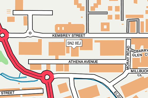
SN2 8EJ is located in the Gorse Hill and Pinehurst electoral ward, within the unitary authority of Swindon and the English Parliamentary constituency of North Swindon. The Sub Integrated Care Board (ICB) Location is NHS Bath and North East Somerset, Swindon and Wiltshire ICB - 92 and the police force is Wiltshire. This postcode has been in use since June 2000.


GetTheData
Source: OS OpenMap – Local (Ordnance Survey)
Source: OS VectorMap District (Ordnance Survey)
Licence: Open Government Licence (requires attribution)
| Easting | 416031 |
| Northing | 186480 |
| Latitude | 51.576959 |
| Longitude | -1.770060 |
GetTheData
Source: Open Postcode Geo
Licence: Open Government Licence
| Country | England |
| Postcode District | SN2 |
| ➜ SN2 open data dashboard ➜ See where SN2 is on a map ➜ Where is Swindon? | |
GetTheData
Source: Land Registry Price Paid Data
Licence: Open Government Licence
Elevation or altitude of SN2 8EJ as distance above sea level:
| Metres | Feet | |
|---|---|---|
| Elevation | 100m | 328ft |
Elevation is measured from the approximate centre of the postcode, to the nearest point on an OS contour line from OS Terrain 50, which has contour spacing of ten vertical metres.
➜ How high above sea level am I? Find the elevation of your current position using your device's GPS.
GetTheData
Source: Open Postcode Elevation
Licence: Open Government Licence
| Ward | Gorse Hill And Pinehurst |
| Constituency | North Swindon |
GetTheData
Source: ONS Postcode Database
Licence: Open Government Licence
| June 2022 | Violence and sexual offences | On or near Parking Area | 192m |
| June 2022 | Anti-social behaviour | On or near Parking Area | 192m |
| June 2022 | Criminal damage and arson | On or near A4311 | 283m |
| ➜ Get more crime data in our Crime section | |||
GetTheData
Source: data.police.uk
Licence: Open Government Licence
| Kembrey Inn (Kembrey Street) | Kembrey Park | 131m |
| Cherry Orchard (Kembrey Park) | Kembrey Park | 215m |
| Kembrey Inn (Kembrey Drive) | Kembrey Park | 226m |
| Bramble Road (Kembrey Street) | Kembrey Park | 311m |
| Walnut Court (Kembrey Park) | Kembrey Park | 313m |
| Swindon Station | 1.7km |
GetTheData
Source: NaPTAN
Licence: Open Government Licence
GetTheData
Source: ONS Postcode Database
Licence: Open Government Licence


➜ Get more ratings from the Food Standards Agency
GetTheData
Source: Food Standards Agency
Licence: FSA terms & conditions
| Last Collection | |||
|---|---|---|---|
| Location | Mon-Fri | Sat | Distance |
| Elgin Industrial Estate | 18:30 | 11:30 | 119m |
| Crowdys Hill | 17:30 | 12:00 | 498m |
| Cricklade Road | 17:30 | 12:00 | 528m |
GetTheData
Source: Dracos
Licence: Creative Commons Attribution-ShareAlike
| Facility | Distance |
|---|---|
| Next Generation Health Club (Swindon - Kembrey Park) (Closed) Kembrey Street, Kembrey Park, Swindon Health and Fitness Gym, Swimming Pool, Indoor Tennis Centre, Sports Hall, Studio, Squash Courts, Outdoor Tennis Courts | 287m |
| Crowdys Hill School Jefferies Avenue, Swindon Grass Pitches | 395m |
| Playfootball (Swindon) (Closed) Bramble Road, Techno Trading Estate, Swindon Sports Hall, Artificial Grass Pitch | 434m |
GetTheData
Source: Active Places
Licence: Open Government Licence
| School | Phase of Education | Distance |
|---|---|---|
| Crowdys Hill School Jefferies Avenue, Swindon, SN2 7HJ | Not applicable | 425m |
| Gorse Hill Primary School Avening Street, Gorse Hill, Swindon, SN2 8BZ | Primary | 527m |
| Horizons College Bincknoll Lane, Unit 5, Interface Business Park, Royal Wootton Bassett, SN4 8QQ | Not applicable | 1km |
GetTheData
Source: Edubase
Licence: Open Government Licence
The below table lists the International Territorial Level (ITL) codes (formerly Nomenclature of Territorial Units for Statistics (NUTS) codes) and Local Administrative Units (LAU) codes for SN2 8EJ:
| ITL 1 Code | Name |
|---|---|
| TLK | South West (England) |
| ITL 2 Code | Name |
| TLK1 | Gloucestershire, Wiltshire and Bath/Bristol area |
| ITL 3 Code | Name |
| TLK14 | Swindon |
| LAU 1 Code | Name |
| E06000030 | Swindon |
GetTheData
Source: ONS Postcode Directory
Licence: Open Government Licence
The below table lists the Census Output Area (OA), Lower Layer Super Output Area (LSOA), and Middle Layer Super Output Area (MSOA) for SN2 8EJ:
| Code | Name | |
|---|---|---|
| OA | E00078437 | |
| LSOA | E01015509 | Swindon 010B |
| MSOA | E02003221 | Swindon 010 |
GetTheData
Source: ONS Postcode Directory
Licence: Open Government Licence
| SN2 8XA | Moray Road | 148m |
| SN2 8BP | Argyle Street | 288m |
| SN2 8HB | Bramble Road | 335m |
| SN2 8AU | Tydeman Street | 338m |
| SN2 8AX | Tydeman Street | 346m |
| SN2 8AJ | Aspen Close | 355m |
| SN2 8BE | Argyle Street | 380m |
| SN2 8BD | Argyle Street | 388m |
| SN2 8AD | Pine Court | 389m |
| SN2 8DE | Edinburgh Street | 392m |
GetTheData
Source: Open Postcode Geo; Land Registry Price Paid Data
Licence: Open Government Licence