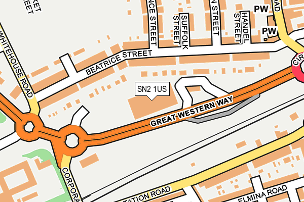
SN2 1US is located in the Gorse Hill and Pinehurst electoral ward, within the unitary authority of Swindon and the English Parliamentary constituency of North Swindon. The Sub Integrated Care Board (ICB) Location is NHS Bath and North East Somerset, Swindon and Wiltshire ICB - 92 and the police force is Wiltshire. This postcode has been in use since January 1992.


GetTheData
Source: OS OpenMap – Local (Ordnance Survey)
Source: OS VectorMap District (Ordnance Survey)
Licence: Open Government Licence (requires attribution)
| Easting | 415318 |
| Northing | 185540 |
| Latitude | 51.568527 |
| Longitude | -1.780389 |
GetTheData
Source: Open Postcode Geo
Licence: Open Government Licence
| Country | England |
| Postcode District | SN2 |
| ➜ SN2 open data dashboard ➜ See where SN2 is on a map ➜ Where is Swindon? | |
GetTheData
Source: Land Registry Price Paid Data
Licence: Open Government Licence
Elevation or altitude of SN2 1US as distance above sea level:
| Metres | Feet | |
|---|---|---|
| Elevation | 100m | 328ft |
Elevation is measured from the approximate centre of the postcode, to the nearest point on an OS contour line from OS Terrain 50, which has contour spacing of ten vertical metres.
➜ How high above sea level am I? Find the elevation of your current position using your device's GPS.
GetTheData
Source: Open Postcode Elevation
Licence: Open Government Licence
| Ward | Gorse Hill And Pinehurst |
| Constituency | North Swindon |
GetTheData
Source: ONS Postcode Database
Licence: Open Government Licence
| January 2024 | Burglary | On or near Parking Area | 302m |
| January 2024 | Shoplifting | On or near Parking Area | 302m |
| January 2024 | Shoplifting | On or near Parking Area | 302m |
| ➜ Get more crime data in our Crime section | |||
GetTheData
Source: data.police.uk
Licence: Open Government Licence
| Beatrice Street (Whitehouse Road) | Swindon | 246m |
| Beatrice Street (Whitehouse Road) | Swindon | 261m |
| Armstrong Street (Corporation Street) | Swindon | 299m |
| Gorse Hill South (Cricklade Road) | Gorse Hill | 319m |
| Gladstone Street (Manchester Road) | Swindon | 363m |
| Swindon Station | 0.5km |
GetTheData
Source: NaPTAN
Licence: Open Government Licence
GetTheData
Source: ONS Postcode Database
Licence: Open Government Licence


➜ Get more ratings from the Food Standards Agency
GetTheData
Source: Food Standards Agency
Licence: FSA terms & conditions
| Last Collection | |||
|---|---|---|---|
| Location | Mon-Fri | Sat | Distance |
| Beatrice Street | 17:30 | 12:00 | 114m |
| Norman Road | 17:30 | 12:00 | 374m |
| Manchester Road | 17:30 | 12:45 | 387m |
GetTheData
Source: Dracos
Licence: Creative Commons Attribution-ShareAlike
| Facility | Distance |
|---|---|
| St Marks Recreation Ground (Swindon) Ipswich Street, Swindon Outdoor Tennis Courts | 298m |
| Swindon Cricket Club (The County Ground) County Road, Swindon Grass Pitches | 585m |
| Gorse Hill Primary School Avening Street, Gorse Hill, Swindon Artificial Grass Pitch | 636m |
GetTheData
Source: Active Places
Licence: Open Government Licence
| School | Phase of Education | Distance |
|---|---|---|
| Gorse Hill Primary School Avening Street, Gorse Hill, Swindon, SN2 8BZ | Primary | 657m |
| EOTAS Swindon Ferndale Road, Ferndale, Swindon, SN2 1HL | Not applicable | 734m |
| Ferndale Primary School & Nursery Wiltshire Avenue, Wiltshire Avenue, swindon, SN2 1NX | Primary | 941m |
GetTheData
Source: Edubase
Licence: Open Government Licence
The below table lists the International Territorial Level (ITL) codes (formerly Nomenclature of Territorial Units for Statistics (NUTS) codes) and Local Administrative Units (LAU) codes for SN2 1US:
| ITL 1 Code | Name |
|---|---|
| TLK | South West (England) |
| ITL 2 Code | Name |
| TLK1 | Gloucestershire, Wiltshire and Bath/Bristol area |
| ITL 3 Code | Name |
| TLK14 | Swindon |
| LAU 1 Code | Name |
| E06000030 | Swindon |
GetTheData
Source: ONS Postcode Directory
Licence: Open Government Licence
The below table lists the Census Output Area (OA), Lower Layer Super Output Area (LSOA), and Middle Layer Super Output Area (MSOA) for SN2 1US:
| Code | Name | |
|---|---|---|
| OA | E00078423 | |
| LSOA | E01015510 | Swindon 010C |
| MSOA | E02003221 | Swindon 010 |
GetTheData
Source: ONS Postcode Directory
Licence: Open Government Licence
| SN2 1BD | Beatrice Street | 112m |
| SN2 1BJ | Beatrice Street | 131m |
| SN2 1BB | Beatrice Street | 149m |
| SN2 1BE | Beatrice Street | 163m |
| SN2 1BL | Suffolk Street | 174m |
| SN1 2BB | Station Road | 200m |
| SN1 2BA | Gooch Street | 206m |
| SN1 2AY | Gladstone Street | 213m |
| SN2 1BA | Florence Street | 216m |
| SN2 1BG | Beatrice Street | 217m |
GetTheData
Source: Open Postcode Geo; Land Registry Price Paid Data
Licence: Open Government Licence