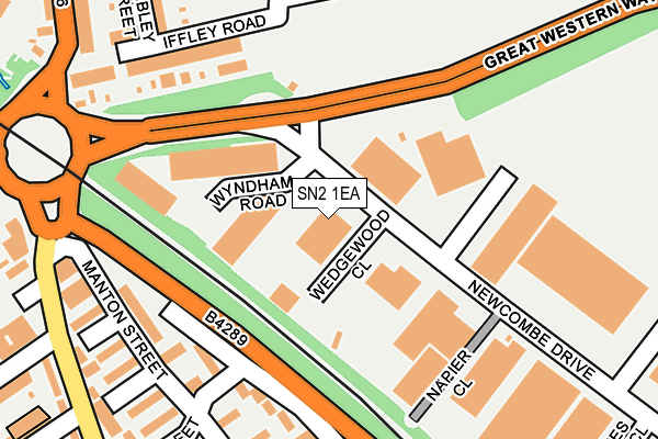
SN2 1EA is located in the Rodbourne Cheney electoral ward, within the unitary authority of Swindon and the English Parliamentary constituency of North Swindon. The Sub Integrated Care Board (ICB) Location is NHS Bath and North East Somerset, Swindon and Wiltshire ICB - 92 and the police force is Wiltshire. This postcode has been in use since January 1980.


GetTheData
Source: OS OpenMap – Local (Ordnance Survey)
Source: OS VectorMap District (Ordnance Survey)
Licence: Open Government Licence (requires attribution)
| Easting | 414122 |
| Northing | 185478 |
| Latitude | 51.568001 |
| Longitude | -1.797647 |
GetTheData
Source: Open Postcode Geo
Licence: Open Government Licence
| Country | England |
| Postcode District | SN2 |
| ➜ SN2 open data dashboard ➜ See where SN2 is on a map ➜ Where is Swindon? | |
GetTheData
Source: Land Registry Price Paid Data
Licence: Open Government Licence
Elevation or altitude of SN2 1EA as distance above sea level:
| Metres | Feet | |
|---|---|---|
| Elevation | 100m | 328ft |
Elevation is measured from the approximate centre of the postcode, to the nearest point on an OS contour line from OS Terrain 50, which has contour spacing of ten vertical metres.
➜ How high above sea level am I? Find the elevation of your current position using your device's GPS.
GetTheData
Source: Open Postcode Elevation
Licence: Open Government Licence
| Ward | Rodbourne Cheney |
| Constituency | North Swindon |
GetTheData
Source: ONS Postcode Database
Licence: Open Government Licence
| January 2024 | Anti-social behaviour | On or near Percy Street | 449m |
| January 2024 | Public order | On or near Percy Street | 449m |
| December 2023 | Criminal damage and arson | On or near Percy Street | 449m |
| ➜ Get more crime data in our Crime section | |||
GetTheData
Source: data.police.uk
Licence: Open Government Licence
| Summers Street (Rodbourne Road) | Even Swindon | 276m |
| Summers Street (Rodbourne Road) | Even Swindon | 286m |
| Steam Museum (Kemble Drive) | Even Swindon | 364m |
| Steam Museum | Even Swindon | 393m |
| The Dolphin (Rodbourne Road) | Even Swindon | 418m |
| Swindon Station | 0.9km |
GetTheData
Source: NaPTAN
Licence: Open Government Licence
GetTheData
Source: ONS Postcode Database
Licence: Open Government Licence


➜ Get more ratings from the Food Standards Agency
GetTheData
Source: Food Standards Agency
Licence: FSA terms & conditions
| Last Collection | |||
|---|---|---|---|
| Location | Mon-Fri | Sat | Distance |
| 169/170 Rodbourne Road | 17:30 | 12:00 | 369m |
| Ferndale Road | 17:45 | 12:00 | 377m |
| Hawksworth Industrial Estate | 18:30 | 12:30 | 414m |
GetTheData
Source: Dracos
Licence: Creative Commons Attribution-ShareAlike
| Facility | Distance |
|---|---|
| Oasis Leisure Centre (Swindon) (Closed) North Star Avenue, Swindon Sports Hall, Indoor Bowls, Swimming Pool, Health and Fitness Gym, Squash Courts, Studio, Artificial Grass Pitch, Cycling | 475m |
| Even Swindon Primary School Pasture Close, Swindon Sports Hall, Grass Pitches, Artificial Grass Pitch | 563m |
| Battleground Fitness Cheney Manor Industrial Estate, Swindon Health and Fitness Gym, Studio | 650m |
GetTheData
Source: Active Places
Licence: Open Government Licence
| School | Phase of Education | Distance |
|---|---|---|
| Even Swindon Primary School Pasture Close, Raybrook Park, Swindon, SN2 2UJ | Primary | 562m |
| Ferndale Primary School & Nursery Wiltshire Avenue, Wiltshire Avenue, swindon, SN2 1NX | Primary | 602m |
| EOTAS Swindon Ferndale Road, Ferndale, Swindon, SN2 1HL | Not applicable | 657m |
GetTheData
Source: Edubase
Licence: Open Government Licence
The below table lists the International Territorial Level (ITL) codes (formerly Nomenclature of Territorial Units for Statistics (NUTS) codes) and Local Administrative Units (LAU) codes for SN2 1EA:
| ITL 1 Code | Name |
|---|---|
| TLK | South West (England) |
| ITL 2 Code | Name |
| TLK1 | Gloucestershire, Wiltshire and Bath/Bristol area |
| ITL 3 Code | Name |
| TLK14 | Swindon |
| LAU 1 Code | Name |
| E06000030 | Swindon |
GetTheData
Source: ONS Postcode Directory
Licence: Open Government Licence
The below table lists the Census Output Area (OA), Lower Layer Super Output Area (LSOA), and Middle Layer Super Output Area (MSOA) for SN2 1EA:
| Code | Name | |
|---|---|---|
| OA | E00078804 | |
| LSOA | E01015578 | Swindon 012B |
| MSOA | E02003223 | Swindon 012 |
GetTheData
Source: ONS Postcode Directory
Licence: Open Government Licence
| SN2 2AP | Barnum Court | 179m |
| SN2 2AR | Barnum Court | 211m |
| SN2 1DL | Iffley Road | 215m |
| SN2 1DR | Harcourt Road | 238m |
| SN2 2AL | Manton Street | 239m |
| SN2 1DW | Cobden Road | 261m |
| SN2 2AH | Thomas Street | 271m |
| SN2 1DN | Wembley Street | 275m |
| SN2 2AX | Rodbourne Road | 280m |
| SN2 2AS | Romsey Street | 297m |
GetTheData
Source: Open Postcode Geo; Land Registry Price Paid Data
Licence: Open Government Licence