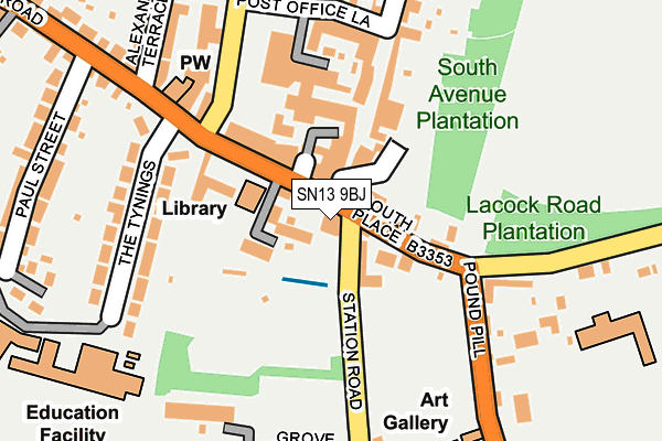
SN13 9BJ is located in the Corsham Ladbrook electoral ward, within the unitary authority of Wiltshire and the English Parliamentary constituency of Chippenham. The Sub Integrated Care Board (ICB) Location is NHS Bath and North East Somerset, Swindon and Wiltshire ICB - 92 and the police force is Wiltshire. This postcode has been in use since January 1980.


GetTheData
Source: OS OpenMap – Local (Ordnance Survey)
Source: OS VectorMap District (Ordnance Survey)
Licence: Open Government Licence (requires attribution)
| Easting | 387144 |
| Northing | 170223 |
| Latitude | 51.430860 |
| Longitude | -2.186311 |
GetTheData
Source: Open Postcode Geo
Licence: Open Government Licence
| Country | England |
| Postcode District | SN13 |
| ➜ SN13 open data dashboard ➜ See where SN13 is on a map ➜ Where is Corsham? | |
GetTheData
Source: Land Registry Price Paid Data
Licence: Open Government Licence
Elevation or altitude of SN13 9BJ as distance above sea level:
| Metres | Feet | |
|---|---|---|
| Elevation | 90m | 295ft |
Elevation is measured from the approximate centre of the postcode, to the nearest point on an OS contour line from OS Terrain 50, which has contour spacing of ten vertical metres.
➜ How high above sea level am I? Find the elevation of your current position using your device's GPS.
GetTheData
Source: Open Postcode Elevation
Licence: Open Government Licence
| Ward | Corsham Ladbrook |
| Constituency | Chippenham |
GetTheData
Source: ONS Postcode Database
Licence: Open Government Licence
| November 2023 | Criminal damage and arson | On or near Parking Area | 240m |
| November 2023 | Other theft | On or near Parking Area | 240m |
| October 2023 | Other theft | On or near Parking Area | 240m |
| ➜ Get more crime data in our Crime section | |||
GetTheData
Source: data.police.uk
Licence: Open Government Licence
| Library (Pickwick Road) | Corsham | 87m |
| Library (Pickwick Road) | Corsham | 90m |
| War Memorial (Lacock Road) | Corsham | 169m |
| War Memorial (Lacock Road) | Corsham | 172m |
| Somerfield (Newlands Road) | Corsham | 180m |
| Chippenham Station | 6.1km |
GetTheData
Source: NaPTAN
Licence: Open Government Licence
| Percentage of properties with Next Generation Access | 100.0% |
| Percentage of properties with Superfast Broadband | 100.0% |
| Percentage of properties with Ultrafast Broadband | 0.0% |
| Percentage of properties with Full Fibre Broadband | 0.0% |
Superfast Broadband is between 30Mbps and 300Mbps
Ultrafast Broadband is > 300Mbps
| Percentage of properties unable to receive 2Mbps | 0.0% |
| Percentage of properties unable to receive 5Mbps | 0.0% |
| Percentage of properties unable to receive 10Mbps | 0.0% |
| Percentage of properties unable to receive 30Mbps | 0.0% |
GetTheData
Source: Ofcom
Licence: Ofcom Terms of Use (requires attribution)
GetTheData
Source: ONS Postcode Database
Licence: Open Government Licence
➜ Get more ratings from the Food Standards Agency
GetTheData
Source: Food Standards Agency
Licence: FSA terms & conditions
| Last Collection | |||
|---|---|---|---|
| Location | Mon-Fri | Sat | Distance |
| Prospect Post Office | 17:30 | 11:45 | 122m |
| Priory Street | 17:45 | 12:00 | 556m |
| Valley Road | 17:45 | 11:45 | 638m |
GetTheData
Source: Dracos
Licence: Creative Commons Attribution-ShareAlike
| Facility | Distance |
|---|---|
| Corsham Cricket Club Station Road, Corsham Grass Pitches | 70m |
| Meriton Avenue Recreation Ground Meriton Avenue, Corsham Grass Pitches | 353m |
| Corsham Primary School Pound Pill, Corsham Grass Pitches | 367m |
GetTheData
Source: Active Places
Licence: Open Government Licence
| School | Phase of Education | Distance |
|---|---|---|
| St Patrick's Catholic Primary School, Corsham Lacock Road, Corsham, SN13 9HS | Primary | 287m |
| Corsham Primary School Pound Pill, Corsham, SN13 9YW | Primary | 367m |
| Heywood Prep The Priory, Priory Street, Corsham, SN13 0AP | Not applicable | 397m |
GetTheData
Source: Edubase
Licence: Open Government Licence
The below table lists the International Territorial Level (ITL) codes (formerly Nomenclature of Territorial Units for Statistics (NUTS) codes) and Local Administrative Units (LAU) codes for SN13 9BJ:
| ITL 1 Code | Name |
|---|---|
| TLK | South West (England) |
| ITL 2 Code | Name |
| TLK1 | Gloucestershire, Wiltshire and Bath/Bristol area |
| ITL 3 Code | Name |
| TLK15 | Wiltshire |
| LAU 1 Code | Name |
| E06000054 | Wiltshire |
GetTheData
Source: ONS Postcode Directory
Licence: Open Government Licence
The below table lists the Census Output Area (OA), Lower Layer Super Output Area (LSOA), and Middle Layer Super Output Area (MSOA) for SN13 9BJ:
| Code | Name | |
|---|---|---|
| OA | E00162856 | |
| LSOA | E01031931 | Wiltshire 018A |
| MSOA | E02006660 | Wiltshire 018 |
GetTheData
Source: ONS Postcode Directory
Licence: Open Government Licence
| SN13 9BB | Mansion House Mews | 36m |
| SN13 9EU | Station Road | 56m |
| SN13 9BQ | Pickwick Road | 85m |
| SN13 9BL | Pickwick Road | 94m |
| SN13 0ES | High Street | 97m |
| SN13 0HB | High Street | 124m |
| SN13 9DE | The Tynings | 144m |
| SN13 0HQ | High Street | 169m |
| SN13 9HJ | Grove Road | 186m |
| SN13 0BH | Newlands Road | 209m |
GetTheData
Source: Open Postcode Geo; Land Registry Price Paid Data
Licence: Open Government Licence