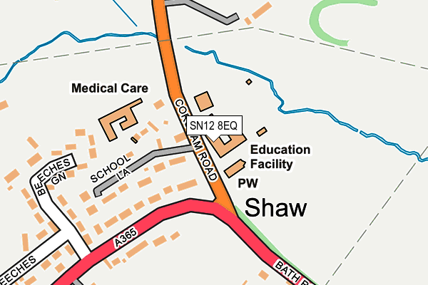
SN12 8EQ is located in the Melksham Without North & Shurnhold electoral ward, within the unitary authority of Wiltshire and the English Parliamentary constituency of Chippenham. The Sub Integrated Care Board (ICB) Location is NHS Bath and North East Somerset, Swindon and Wiltshire ICB - 92 and the police force is Wiltshire. This postcode has been in use since January 1980.


GetTheData
Source: OS OpenMap – Local (Ordnance Survey)
Source: OS VectorMap District (Ordnance Survey)
Licence: Open Government Licence (requires attribution)
| Easting | 388837 |
| Northing | 165756 |
| Latitude | 51.390730 |
| Longitude | -2.161816 |
GetTheData
Source: Open Postcode Geo
Licence: Open Government Licence
| Country | England |
| Postcode District | SN12 |
| ➜ SN12 open data dashboard ➜ See where SN12 is on a map ➜ Where is Shaw? | |
GetTheData
Source: Land Registry Price Paid Data
Licence: Open Government Licence
Elevation or altitude of SN12 8EQ as distance above sea level:
| Metres | Feet | |
|---|---|---|
| Elevation | 50m | 164ft |
Elevation is measured from the approximate centre of the postcode, to the nearest point on an OS contour line from OS Terrain 50, which has contour spacing of ten vertical metres.
➜ How high above sea level am I? Find the elevation of your current position using your device's GPS.
GetTheData
Source: Open Postcode Elevation
Licence: Open Government Licence
| Ward | Melksham Without North & Shurnhold |
| Constituency | Chippenham |
GetTheData
Source: ONS Postcode Database
Licence: Open Government Licence
| June 2022 | Public order | On or near Beeches Green | 252m |
| May 2022 | Vehicle crime | On or near Green Beeches | 238m |
| March 2022 | Anti-social behaviour | On or near Kennedy Avenue | 366m |
| ➜ Get more crime data in our Crime section | |||
GetTheData
Source: data.police.uk
Licence: Open Government Licence
| Christ Church (Bath Road) | Shaw | 34m |
| Christ Church (Bath Road) | Shaw | 42m |
| Church Farm For Church (Bath Road) | Shaw | 256m |
| Lodge (Shaw Hill) | Shaw | 269m |
| First Lane (Corsham Road) | Whitley | 269m |
| Melksham Station | 1.7km |
GetTheData
Source: NaPTAN
Licence: Open Government Licence
GetTheData
Source: ONS Postcode Database
Licence: Open Government Licence


➜ Get more ratings from the Food Standards Agency
GetTheData
Source: Food Standards Agency
Licence: FSA terms & conditions
| Last Collection | |||
|---|---|---|---|
| Location | Mon-Fri | Sat | Distance |
| Westwells | 16:30 | 10:15 | 716m |
| Beanacre | 17:30 | 07:00 | 1,539m |
| Beanacre Road | 17:30 | 11:00 | 1,611m |
GetTheData
Source: Dracos
Licence: Creative Commons Attribution-ShareAlike
| Facility | Distance |
|---|---|
| Whitley Golf Club Corsham Road, Shaw, Melksham Golf | 195m |
| Shaw Village Hall The Beeches, Shaw Grass Pitches | 357m |
| The George Ward School (Closed) Shurnhold, Melksham Grass Pitches, Sports Hall | 1.2km |
GetTheData
Source: Active Places
Licence: Open Government Licence
| School | Phase of Education | Distance |
|---|---|---|
| Shaw CE Primary School Corsham Road, Shaw, Melksham, SN12 8EQ | Primary | 0m |
| River Mead School Lowbourne, Melksham, SN12 7ED | Primary | 2.4km |
| The Manor CofE VC Primary School Ruskin Avenue, Melksham, SN12 7NG | Primary | 2.6km |
GetTheData
Source: Edubase
Licence: Open Government Licence
The below table lists the International Territorial Level (ITL) codes (formerly Nomenclature of Territorial Units for Statistics (NUTS) codes) and Local Administrative Units (LAU) codes for SN12 8EQ:
| ITL 1 Code | Name |
|---|---|
| TLK | South West (England) |
| ITL 2 Code | Name |
| TLK1 | Gloucestershire, Wiltshire and Bath/Bristol area |
| ITL 3 Code | Name |
| TLK15 | Wiltshire |
| LAU 1 Code | Name |
| E06000054 | Wiltshire |
GetTheData
Source: ONS Postcode Directory
Licence: Open Government Licence
The below table lists the Census Output Area (OA), Lower Layer Super Output Area (LSOA), and Middle Layer Super Output Area (MSOA) for SN12 8EQ:
| Code | Name | |
|---|---|---|
| OA | E00163445 | |
| LSOA | E01032044 | Wiltshire 021B |
| MSOA | E02006679 | Wiltshire 021 |
GetTheData
Source: ONS Postcode Directory
Licence: Open Government Licence
| SN12 8EH | Corsham Road | 97m |
| SN12 8EN | Shaw Hill | 115m |
| SN12 8EJ | School Lane | 118m |
| SN12 8EL | Shaw Hill | 193m |
| SN12 8JD | Beeches Green | 221m |
| SN12 8EW | The Beeches | 222m |
| SN12 8ES | Shaw Hill | 278m |
| SN12 8QE | Corsham Road | 302m |
| SN12 8ET | Shaw Hill | 331m |
| SN12 8ER | The Beeches | 353m |
GetTheData
Source: Open Postcode Geo; Land Registry Price Paid Data
Licence: Open Government Licence