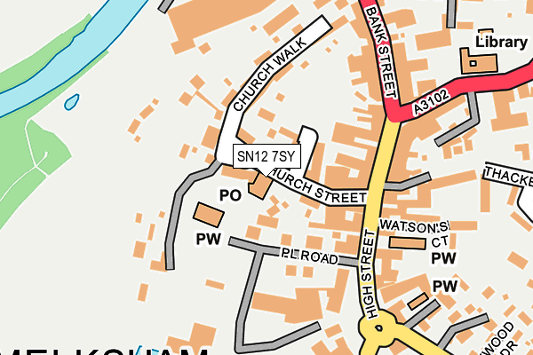
SN12 7SY is located in the Melksham South electoral ward, within the unitary authority of Wiltshire and the English Parliamentary constituency of Chippenham. The Sub Integrated Care Board (ICB) Location is NHS Bath and North East Somerset, Swindon and Wiltshire ICB - 92 and the police force is Wiltshire. This postcode has been in use since December 1994.


GetTheData
Source: OS OpenMap – Local (Ordnance Survey)
Source: OS VectorMap District (Ordnance Survey)
Licence: Open Government Licence (requires attribution)
| Easting | 390354 |
| Northing | 163772 |
| Latitude | 51.372921 |
| Longitude | -2.139964 |
GetTheData
Source: Open Postcode Geo
Licence: Open Government Licence
| Country | England |
| Postcode District | SN12 |
| ➜ SN12 open data dashboard ➜ See where SN12 is on a map ➜ Where is Melksham? | |
GetTheData
Source: Land Registry Price Paid Data
Licence: Open Government Licence
Elevation or altitude of SN12 7SY as distance above sea level:
| Metres | Feet | |
|---|---|---|
| Elevation | 40m | 131ft |
Elevation is measured from the approximate centre of the postcode, to the nearest point on an OS contour line from OS Terrain 50, which has contour spacing of ten vertical metres.
➜ How high above sea level am I? Find the elevation of your current position using your device's GPS.
GetTheData
Source: Open Postcode Elevation
Licence: Open Government Licence
| Ward | Melksham South |
| Constituency | Chippenham |
GetTheData
Source: ONS Postcode Database
Licence: Open Government Licence
| January 2024 | Public order | On or near Parking Area | 235m |
| January 2024 | Anti-social behaviour | On or near Parking Area | 235m |
| January 2024 | Burglary | On or near Parking Area | 235m |
| ➜ Get more crime data in our Crime section | |||
GetTheData
Source: data.police.uk
Licence: Open Government Licence
| Market Place (High Street) | Melksham | 142m |
| Market Place (High Street) | Melksham | 154m |
| Buds Bar (Lowbourne) | Melksham | 187m |
| Sainsbury (Car Park) | Melksham | 224m |
| Library (Lowbourne) | Melksham | 229m |
| Melksham Station | 0.8km |
GetTheData
Source: NaPTAN
Licence: Open Government Licence
GetTheData
Source: ONS Postcode Database
Licence: Open Government Licence


➜ Get more ratings from the Food Standards Agency
GetTheData
Source: Food Standards Agency
Licence: FSA terms & conditions
| Last Collection | |||
|---|---|---|---|
| Location | Mon-Fri | Sat | Distance |
| Market Place | 17:45 | 12:30 | 153m |
| Seven Seas | 17:30 | 11:15 | 279m |
| Bath Road Post Office | 18:00 | 11:15 | 516m |
GetTheData
Source: Dracos
Licence: Creative Commons Attribution-ShareAlike
| Facility | Distance |
|---|---|
| Melksham Blue Pool (Closed) Market Place, Melksham Swimming Pool, Health and Fitness Gym | 143m |
| Melksham House Market Place, Melksham Grass Pitches, Outdoor Tennis Courts | 195m |
| The Conigre (Closed) Market Place, Melksham Grass Pitches | 237m |
GetTheData
Source: Active Places
Licence: Open Government Licence
| School | Phase of Education | Distance |
|---|---|---|
| The Manor CofE VC Primary School Ruskin Avenue, Melksham, SN12 7NG | Primary | 377m |
| Aloeric Primary School St Michael's Road, Melksham, SN12 6HN | Primary | 465m |
| River Mead School Lowbourne, Melksham, SN12 7ED | Primary | 701m |
GetTheData
Source: Edubase
Licence: Open Government Licence
The below table lists the International Territorial Level (ITL) codes (formerly Nomenclature of Territorial Units for Statistics (NUTS) codes) and Local Administrative Units (LAU) codes for SN12 7SY:
| ITL 1 Code | Name |
|---|---|
| TLK | South West (England) |
| ITL 2 Code | Name |
| TLK1 | Gloucestershire, Wiltshire and Bath/Bristol area |
| ITL 3 Code | Name |
| TLK15 | Wiltshire |
| LAU 1 Code | Name |
| E06000054 | Wiltshire |
GetTheData
Source: ONS Postcode Directory
Licence: Open Government Licence
The below table lists the Census Output Area (OA), Lower Layer Super Output Area (LSOA), and Middle Layer Super Output Area (MSOA) for SN12 7SY:
| Code | Name | |
|---|---|---|
| OA | E00163556 | |
| LSOA | E01032067 | Wiltshire 022C |
| MSOA | E02006680 | Wiltshire 022 |
GetTheData
Source: ONS Postcode Directory
Licence: Open Government Licence
| SN12 6LX | Canon Square | 49m |
| SN12 6US | Canons Court | 49m |
| SN12 6LS | Church Street | 66m |
| SN12 6JN | Place Road | 76m |
| SN12 6JR | High Street | 109m |
| SN12 6LY | Church Walk | 110m |
| SN12 6JY | High Street | 121m |
| SN12 6JU | High Street | 146m |
| SN12 6YE | Perretts Court | 151m |
| SN12 6LA | High Street | 151m |
GetTheData
Source: Open Postcode Geo; Land Registry Price Paid Data
Licence: Open Government Licence