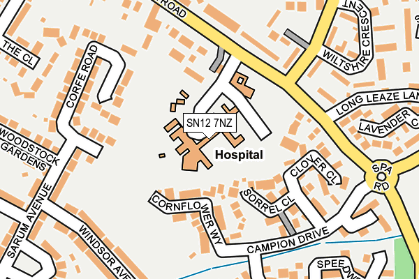
SN12 7NZ is located in the Melksham South electoral ward, within the unitary authority of Wiltshire and the English Parliamentary constituency of Chippenham. The Sub Integrated Care Board (ICB) Location is NHS Bath and North East Somerset, Swindon and Wiltshire ICB - 92 and the police force is Wiltshire. This postcode has been in use since February 1984.


GetTheData
Source: OS OpenMap – Local (Ordnance Survey)
Source: OS VectorMap District (Ordnance Survey)
Licence: Open Government Licence (requires attribution)
| Easting | 390939 |
| Northing | 163127 |
| Latitude | 51.367131 |
| Longitude | -2.131543 |
GetTheData
Source: Open Postcode Geo
Licence: Open Government Licence
| Country | England |
| Postcode District | SN12 |
| ➜ SN12 open data dashboard ➜ See where SN12 is on a map ➜ Where is Melksham? | |
GetTheData
Source: Land Registry Price Paid Data
Licence: Open Government Licence
Elevation or altitude of SN12 7NZ as distance above sea level:
| Metres | Feet | |
|---|---|---|
| Elevation | 40m | 131ft |
Elevation is measured from the approximate centre of the postcode, to the nearest point on an OS contour line from OS Terrain 50, which has contour spacing of ten vertical metres.
➜ How high above sea level am I? Find the elevation of your current position using your device's GPS.
GetTheData
Source: Open Postcode Elevation
Licence: Open Government Licence
| Ward | Melksham South |
| Constituency | Chippenham |
GetTheData
Source: ONS Postcode Database
Licence: Open Government Licence
| October 2023 | Violence and sexual offences | On or near Cornflower Way | 102m |
| October 2023 | Anti-social behaviour | On or near Cornflower Way | 102m |
| October 2023 | Violence and sexual offences | On or near Cornflower Way | 102m |
| ➜ Get more crime data in our Crime section | |||
GetTheData
Source: data.police.uk
Licence: Open Government Licence
| Hospital (Spa Road) | Melksham | 121m |
| Hospital (Spa Road) | Melksham | 132m |
| Spa Road | Melksham | 198m |
| Spa Road | Melksham | 207m |
| Wiltshire Crescent (Queensway) | Melksham | 241m |
| Melksham Station | 1.7km |
GetTheData
Source: NaPTAN
Licence: Open Government Licence
GetTheData
Source: ONS Postcode Database
Licence: Open Government Licence


➜ Get more ratings from the Food Standards Agency
GetTheData
Source: Food Standards Agency
Licence: FSA terms & conditions
| Last Collection | |||
|---|---|---|---|
| Location | Mon-Fri | Sat | Distance |
| Burnet Close | 17:30 | 11:45 | 209m |
| Sarum Avenue | 17:45 | 12:30 | 292m |
| Coronation Road | 17:45 | 11:30 | 294m |
GetTheData
Source: Dracos
Licence: Creative Commons Attribution-ShareAlike
| Facility | Distance |
|---|---|
| Hospital Pitch Campion Drive Cornflower Way, Melksham Grass Pitches | 171m |
| Aloeric Primary School St. Michaels Road, Melksham Grass Pitches | 668m |
| St Michaels C Of E Primary School (Closed) Queensway, Melksham Grass Pitches | 690m |
GetTheData
Source: Active Places
Licence: Open Government Licence
| School | Phase of Education | Distance |
|---|---|---|
| Aloeric Primary School St Michael's Road, Melksham, SN12 6HN | Primary | 664m |
| The Manor CofE VC Primary School Ruskin Avenue, Melksham, SN12 7NG | Primary | 830m |
| Melksham Oak Community School Bowerhill, Melksham, SN12 6QZ | Secondary | 1.1km |
GetTheData
Source: Edubase
Licence: Open Government Licence
The below table lists the International Territorial Level (ITL) codes (formerly Nomenclature of Territorial Units for Statistics (NUTS) codes) and Local Administrative Units (LAU) codes for SN12 7NZ:
| ITL 1 Code | Name |
|---|---|
| TLK | South West (England) |
| ITL 2 Code | Name |
| TLK1 | Gloucestershire, Wiltshire and Bath/Bristol area |
| ITL 3 Code | Name |
| TLK15 | Wiltshire |
| LAU 1 Code | Name |
| E06000054 | Wiltshire |
GetTheData
Source: ONS Postcode Directory
Licence: Open Government Licence
The below table lists the Census Output Area (OA), Lower Layer Super Output Area (LSOA), and Middle Layer Super Output Area (MSOA) for SN12 7NZ:
| Code | Name | |
|---|---|---|
| OA | E00163564 | |
| LSOA | E01032069 | Wiltshire 022E |
| MSOA | E02006680 | Wiltshire 022 |
GetTheData
Source: ONS Postcode Directory
Licence: Open Government Licence
| SN12 7SW | Cornflower Way | 77m |
| SN12 7SH | Sorrel Close | 127m |
| SN12 7SN | Cornflower Way | 128m |
| SN12 7SG | Pennycress Drive | 149m |
| SN12 7SL | Clover Close | 150m |
| SN12 7SQ | Pennycress Drive | 153m |
| SN12 6BH | Corfe Road | 157m |
| SN12 7NY | Spa Road | 161m |
| SN12 7PB | Spa Road | 176m |
| SN12 7JY | Queensway | 178m |
GetTheData
Source: Open Postcode Geo; Land Registry Price Paid Data
Licence: Open Government Licence