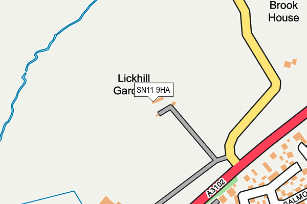
SN11 9HA lies on Lickhill Gardens in Calne. SN11 9HA is located in the Calne Rural electoral ward, within the unitary authority of Wiltshire and the English Parliamentary constituency of North Wiltshire. The Sub Integrated Care Board (ICB) Location is NHS Bath and North East Somerset, Swindon and Wiltshire ICB - 92 and the police force is Wiltshire. This postcode has been in use since January 1980.


GetTheData
Source: OS OpenMap – Local (Ordnance Survey)
Source: OS VectorMap District (Ordnance Survey)
Licence: Open Government Licence (requires attribution)
| Easting | 399216 |
| Northing | 172516 |
| Latitude | 51.451625 |
| Longitude | -2.012666 |
GetTheData
Source: Open Postcode Geo
Licence: Open Government Licence
| Street | Lickhill Gardens |
| Town/City | Calne |
| Country | England |
| Postcode District | SN11 |
| ➜ SN11 open data dashboard ➜ See where SN11 is on a map | |
GetTheData
Source: Land Registry Price Paid Data
Licence: Open Government Licence
Elevation or altitude of SN11 9HA as distance above sea level:
| Metres | Feet | |
|---|---|---|
| Elevation | 70m | 230ft |
Elevation is measured from the approximate centre of the postcode, to the nearest point on an OS contour line from OS Terrain 50, which has contour spacing of ten vertical metres.
➜ How high above sea level am I? Find the elevation of your current position using your device's GPS.
GetTheData
Source: Open Postcode Elevation
Licence: Open Government Licence
| Ward | Calne Rural |
| Constituency | North Wiltshire |
GetTheData
Source: ONS Postcode Database
Licence: Open Government Licence
| August 2023 | Violence and sexual offences | On or near Stickleback Road | 493m |
| March 2023 | Violence and sexual offences | On or near Stickleback Road | 493m |
| November 2022 | Criminal damage and arson | On or near Stickleback Road | 493m |
| ➜ Get more crime data in our Crime section | |||
GetTheData
Source: data.police.uk
Licence: Open Government Licence
| Salmons Leap (Lickhill Road) | Calne | 285m |
| Fynamore Primary School (Greenacres Way) | Calne | 538m |
| Lickhill Road (School Road) | Calne | 573m |
| Lickhill Road (School Road) | Calne | 576m |
| Fishers Brook Health Centre (School Road) | Calne | 585m |
GetTheData
Source: NaPTAN
Licence: Open Government Licence
| Percentage of properties with Next Generation Access | 100.0% |
| Percentage of properties with Superfast Broadband | 100.0% |
| Percentage of properties with Ultrafast Broadband | 0.0% |
| Percentage of properties with Full Fibre Broadband | 0.0% |
Superfast Broadband is between 30Mbps and 300Mbps
Ultrafast Broadband is > 300Mbps
| Percentage of properties unable to receive 2Mbps | 0.0% |
| Percentage of properties unable to receive 5Mbps | 0.0% |
| Percentage of properties unable to receive 10Mbps | 0.0% |
| Percentage of properties unable to receive 30Mbps | 0.0% |
GetTheData
Source: Ofcom
Licence: Ofcom Terms of Use (requires attribution)
GetTheData
Source: ONS Postcode Database
Licence: Open Government Licence


➜ Get more ratings from the Food Standards Agency
GetTheData
Source: Food Standards Agency
Licence: FSA terms & conditions
| Last Collection | |||
|---|---|---|---|
| Location | Mon-Fri | Sat | Distance |
| Harriers Close | 16:00 | 11:30 | 569m |
| Newcroft | 17:45 | 12:00 | 717m |
| Braemor Road | 17:30 | 12:00 | 855m |
GetTheData
Source: Dracos
Licence: Creative Commons Attribution-ShareAlike
| Facility | Distance |
|---|---|
| Calne Town Football Club Bremhill View, Calne Grass Pitches | 623m |
| Beversbrook Sports Facility Beversbrook Road, Calne Sports Hall, Grass Pitches, Outdoor Tennis Courts, Artificial Grass Pitch | 790m |
| St Edmunds Rc Primary School Duncan Street, Calne Grass Pitches, Artificial Grass Pitch | 964m |
GetTheData
Source: Active Places
Licence: Open Government Licence
| School | Phase of Education | Distance |
|---|---|---|
| Fynamore Primary School School Road, Calne, SN11 9UG | Primary | 430m |
| Saint Edmund's Roman Catholic Primary School Duncan Street, Calne, SN11 9BX | Primary | 962m |
| Marden Vale CofE Academy William Street, Calne, SN11 9BD | Primary | 1.2km |
GetTheData
Source: Edubase
Licence: Open Government Licence
The below table lists the International Territorial Level (ITL) codes (formerly Nomenclature of Territorial Units for Statistics (NUTS) codes) and Local Administrative Units (LAU) codes for SN11 9HA:
| ITL 1 Code | Name |
|---|---|
| TLK | South West (England) |
| ITL 2 Code | Name |
| TLK1 | Gloucestershire, Wiltshire and Bath/Bristol area |
| ITL 3 Code | Name |
| TLK15 | Wiltshire |
| LAU 1 Code | Name |
| E06000054 | Wiltshire |
GetTheData
Source: ONS Postcode Directory
Licence: Open Government Licence
The below table lists the Census Output Area (OA), Lower Layer Super Output Area (LSOA), and Middle Layer Super Output Area (MSOA) for SN11 9HA:
| Code | Name | |
|---|---|---|
| OA | E00162733 | |
| LSOA | E01031904 | Wiltshire 013B |
| MSOA | E02006655 | Wiltshire 013 |
GetTheData
Source: ONS Postcode Directory
Licence: Open Government Licence
| SN11 9DB | Avon Close | 290m |
| SN11 9HB | 305m | |
| SN11 9EU | Salmons Leap | 342m |
| SN11 9UF | Bream Close | 343m |
| SN11 9DF | Lickhill Road | 358m |
| SN11 9PW | Tench Road | 364m |
| SN11 9PN | Rudd Road | 382m |
| SN11 9UE | Carp Road | 394m |
| SN11 9DG | Kestrel Close | 413m |
| SN11 9EZ | Lickhill Road | 417m |
GetTheData
Source: Open Postcode Geo; Land Registry Price Paid Data
Licence: Open Government Licence