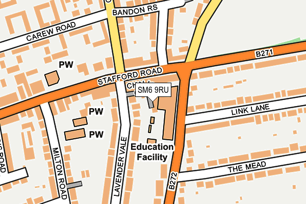
SM6 9RU lies on Chalice Close in Wallington. SM6 9RU is located in the Wallington South electoral ward, within the London borough of Sutton and the English Parliamentary constituency of Carshalton and Wallington. The Sub Integrated Care Board (ICB) Location is NHS South West London ICB - 36L and the police force is Metropolitan Police. This postcode has been in use since January 1980.


GetTheData
Source: OS OpenMap – Local (Ordnance Survey)
Source: OS VectorMap District (Ordnance Survey)
Licence: Open Government Licence (requires attribution)
| Easting | 529684 |
| Northing | 163854 |
| Latitude | 51.358962 |
| Longitude | -0.138810 |
GetTheData
Source: Open Postcode Geo
Licence: Open Government Licence
| Street | Chalice Close |
| Town/City | Wallington |
| Country | England |
| Postcode District | SM6 |
| ➜ SM6 open data dashboard ➜ See where SM6 is on a map ➜ Where is London? | |
GetTheData
Source: Land Registry Price Paid Data
Licence: Open Government Licence
Elevation or altitude of SM6 9RU as distance above sea level:
| Metres | Feet | |
|---|---|---|
| Elevation | 60m | 197ft |
Elevation is measured from the approximate centre of the postcode, to the nearest point on an OS contour line from OS Terrain 50, which has contour spacing of ten vertical metres.
➜ How high above sea level am I? Find the elevation of your current position using your device's GPS.
GetTheData
Source: Open Postcode Elevation
Licence: Open Government Licence
| Ward | Wallington South |
| Constituency | Carshalton And Wallington |
GetTheData
Source: ONS Postcode Database
Licence: Open Government Licence
| January 2024 | Robbery | On or near Parking Area | 331m |
| January 2024 | Criminal damage and arson | On or near Redford Avenue | 387m |
| January 2024 | Other theft | On or near Redford Avenue | 387m |
| ➜ Chalice Close crime map and outcomes | |||
GetTheData
Source: data.police.uk
Licence: Open Government Licence
| Stafford Roadsandy Lane South (Stafford Road) | South Beddington | 56m |
| Sandy Lane South | South Beddington | 74m |
| Stafford Roadsandy Lane South (Stafford Road) | South Beddington | 147m |
| Milton Road (Sm6) (Stafford Road) | South Beddington | 180m |
| Waterer Rise Sandy Lane South (Sandy Lane South) | South Beddington | 193m |
| Wallington Station | 0.9km |
| Waddon Station | 1.8km |
| Carshalton Beeches Station | 2.2km |
GetTheData
Source: NaPTAN
Licence: Open Government Licence
GetTheData
Source: ONS Postcode Database
Licence: Open Government Licence


➜ Get more ratings from the Food Standards Agency
GetTheData
Source: Food Standards Agency
Licence: FSA terms & conditions
| Last Collection | |||
|---|---|---|---|
| Location | Mon-Fri | Sat | Distance |
| Sandy Lane South (School) | 17:45 | 12:00 | 59m |
| Lavender Vale (32) | 17:15 | 12:00 | 109m |
| Milton Road (36) | 17:30 | 12:00 | 262m |
GetTheData
Source: Dracos
Licence: Creative Commons Attribution-ShareAlike
| Facility | Distance |
|---|---|
| Mellows Park Stafford Road, Wallington Grass Pitches, Outdoor Tennis Courts | 376m |
| Foresters Primary School Redford Avenue, Wallington Grass Pitches | 440m |
| Wallington Sports & Social Club Mollison Drive, Wallington Grass Pitches | 522m |
GetTheData
Source: Active Places
Licence: Open Government Licence
| School | Phase of Education | Distance |
|---|---|---|
| Bandon Hill Primary School Sandy Lane South, Wallington, SM6 9QU | Primary | 91m |
| Foresters Primary School Redford Avenue, Wallington, SM6 9DP | Primary | 419m |
| Wilson's School Mollison Drive, Wallington, SM6 9JW | Secondary | 748m |
GetTheData
Source: Edubase
Licence: Open Government Licence
The below table lists the International Territorial Level (ITL) codes (formerly Nomenclature of Territorial Units for Statistics (NUTS) codes) and Local Administrative Units (LAU) codes for SM6 9RU:
| ITL 1 Code | Name |
|---|---|
| TLI | London |
| ITL 2 Code | Name |
| TLI6 | Outer London - South |
| ITL 3 Code | Name |
| TLI63 | Merton, Kingston upon Thames and Sutton |
| LAU 1 Code | Name |
| E09000029 | Sutton |
GetTheData
Source: ONS Postcode Directory
Licence: Open Government Licence
The below table lists the Census Output Area (OA), Lower Layer Super Output Area (LSOA), and Middle Layer Super Output Area (MSOA) for SM6 9RU:
| Code | Name | |
|---|---|---|
| OA | E00020569 | |
| LSOA | E01004086 | Sutton 019B |
| MSOA | E02000858 | Sutton 019 |
GetTheData
Source: ONS Postcode Directory
Licence: Open Government Licence
| SM6 9BT | Stafford Road | 42m |
| SM6 9BS | Stafford Road | 80m |
| SM6 9QX | Sandy Lane South | 108m |
| SM6 8EE | Demesne Road | 120m |
| SM6 9QR | Lavender Vale | 130m |
| SM6 9BN | Stafford Road | 140m |
| SM6 9QT | Lavender Vale | 151m |
| SM6 8PT | Bandon Rise | 171m |
| SM6 9QU | Sandy Lane South | 179m |
| SM6 9EA | Link Lane | 202m |
GetTheData
Source: Open Postcode Geo; Land Registry Price Paid Data
Licence: Open Government Licence