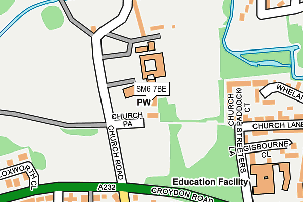
SM6 7BE is located in the Beddington electoral ward, within the London borough of Sutton and the English Parliamentary constituency of Carshalton and Wallington. The Sub Integrated Care Board (ICB) Location is NHS South West London ICB - 36L and the police force is Metropolitan Police. This postcode has been in use since October 2016.


GetTheData
Source: OS OpenMap – Local (Ordnance Survey)
Source: OS VectorMap District (Ordnance Survey)
Licence: Open Government Licence (requires attribution)
| Easting | 529607 |
| Northing | 165229 |
| Latitude | 51.371336 |
| Longitude | -0.139390 |
GetTheData
Source: Open Postcode Geo
Licence: Open Government Licence
| Country | England |
| Postcode District | SM6 |
| ➜ SM6 open data dashboard ➜ See where SM6 is on a map ➜ Where is London? | |
GetTheData
Source: Land Registry Price Paid Data
Licence: Open Government Licence
Elevation or altitude of SM6 7BE as distance above sea level:
| Metres | Feet | |
|---|---|---|
| Elevation | 40m | 131ft |
Elevation is measured from the approximate centre of the postcode, to the nearest point on an OS contour line from OS Terrain 50, which has contour spacing of ten vertical metres.
➜ How high above sea level am I? Find the elevation of your current position using your device's GPS.
GetTheData
Source: Open Postcode Elevation
Licence: Open Government Licence
| Ward | Beddington |
| Constituency | Carshalton And Wallington |
GetTheData
Source: ONS Postcode Database
Licence: Open Government Licence
| January 2024 | Violence and sexual offences | On or near Parking Area | 215m |
| January 2024 | Anti-social behaviour | On or near Parking Area | 215m |
| January 2024 | Anti-social behaviour | On or near Parking Area | 215m |
| ➜ Get more crime data in our Crime section | |||
GetTheData
Source: data.police.uk
Licence: Open Government Licence
| Church Road (Sm6) | Beddington | 168m |
| Church Road (Sm6) | Beddington | 230m |
| The Holt (Croydon Road) | Beddington | 396m |
| Guy Road | Beddington | 416m |
| Hilliers Lane | Beddington | 465m |
| Waddon Marsh Tram Stop (Off Gurney Crescent) | Waddon | 1,621m |
| Ampere Way Tram Stop (Ampere Way) | Broad Green | 1,641m |
| Hackbridge Station | 1.2km |
| Wallington Station | 1.5km |
| Waddon Station | 1.6km |
GetTheData
Source: NaPTAN
Licence: Open Government Licence
GetTheData
Source: ONS Postcode Database
Licence: Open Government Licence


➜ Get more ratings from the Food Standards Agency
GetTheData
Source: Food Standards Agency
Licence: FSA terms & conditions
| Last Collection | |||
|---|---|---|---|
| Location | Mon-Fri | Sat | Distance |
| Desmesne Road (246) | 17:30 | 12:00 | 273m |
| Rookwood Avenue (Opp' 5) | 17:45 | 12:00 | 400m |
| Beddington Lane(2) | 19:00 | 12:00 | 497m |
GetTheData
Source: Dracos
Licence: Creative Commons Attribution-ShareAlike
| Facility | Distance |
|---|---|
| Carew Academy Church Road, Wallington Grass Pitches, Sports Hall | 68m |
| Beddington Cricket Club Church Road, Wallington Grass Pitches | 415m |
| Beddington Park Church Road, Wallington Grass Pitches, Outdoor Tennis Courts | 561m |
GetTheData
Source: Active Places
Licence: Open Government Licence
| School | Phase of Education | Distance |
|---|---|---|
| Carew Academy Church Road, Wallington, SM6 7NH | Not applicable | 68m |
| Sherwood Park School Streeters Lane, Wallington, SM6 7NP | Not applicable | 265m |
| Beddington Park Academy Mallinson Road, Croydon, CR0 4UL | Primary | 446m |
GetTheData
Source: Edubase
Licence: Open Government Licence
The below table lists the International Territorial Level (ITL) codes (formerly Nomenclature of Territorial Units for Statistics (NUTS) codes) and Local Administrative Units (LAU) codes for SM6 7BE:
| ITL 1 Code | Name |
|---|---|
| TLI | London |
| ITL 2 Code | Name |
| TLI6 | Outer London - South |
| ITL 3 Code | Name |
| TLI63 | Merton, Kingston upon Thames and Sutton |
| LAU 1 Code | Name |
| E09000029 | Sutton |
GetTheData
Source: ONS Postcode Directory
Licence: Open Government Licence
The below table lists the Census Output Area (OA), Lower Layer Super Output Area (LSOA), and Middle Layer Super Output Area (MSOA) for SM6 7BE:
| Code | Name | |
|---|---|---|
| OA | E00020547 | |
| LSOA | E01004076 | Sutton 011A |
| MSOA | E02000850 | Sutton 011 |
GetTheData
Source: ONS Postcode Directory
Licence: Open Government Licence
| SM6 7NH | Church Road | 44m |
| SM6 7NW | Church Road | 140m |
| SM6 7NJ | Church Road | 145m |
| SM6 7AW | Church Paddock Court | 155m |
| SM6 7AF | Church Paddock Court | 156m |
| SM6 7AE | Church Paddock Court | 162m |
| SM6 7AQ | Church Paddock Court | 190m |
| SM6 7NP | Streeters Lane | 201m |
| SM6 7LU | Croydon Road | 207m |
| SM6 7NN | Church Road | 208m |
GetTheData
Source: Open Postcode Geo; Land Registry Price Paid Data
Licence: Open Government Licence