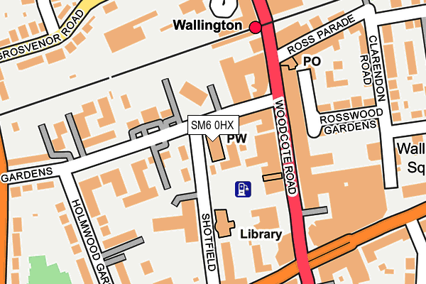
SM6 0HX is located in the Wallington South electoral ward, within the London borough of Sutton and the English Parliamentary constituency of Carshalton and Wallington. The Sub Integrated Care Board (ICB) Location is NHS South West London ICB - 36L and the police force is Metropolitan Police. This postcode has been in use since January 1980.


GetTheData
Source: OS OpenMap – Local (Ordnance Survey)
Source: OS VectorMap District (Ordnance Survey)
Licence: Open Government Licence (requires attribution)
| Easting | 528829 |
| Northing | 163823 |
| Latitude | 51.358877 |
| Longitude | -0.151069 |
GetTheData
Source: Open Postcode Geo
Licence: Open Government Licence
| Country | England |
| Postcode District | SM6 |
| ➜ SM6 open data dashboard ➜ See where SM6 is on a map ➜ Where is Wallington? | |
GetTheData
Source: Land Registry Price Paid Data
Licence: Open Government Licence
Elevation or altitude of SM6 0HX as distance above sea level:
| Metres | Feet | |
|---|---|---|
| Elevation | 60m | 197ft |
Elevation is measured from the approximate centre of the postcode, to the nearest point on an OS contour line from OS Terrain 50, which has contour spacing of ten vertical metres.
➜ How high above sea level am I? Find the elevation of your current position using your device's GPS.
GetTheData
Source: Open Postcode Elevation
Licence: Open Government Licence
| Ward | Wallington South |
| Constituency | Carshalton And Wallington |
GetTheData
Source: ONS Postcode Database
Licence: Open Government Licence
| January 2024 | Anti-social behaviour | On or near Parking Area | 322m |
| December 2023 | Anti-social behaviour | On or near Grosvenor Road | 259m |
| December 2023 | Anti-social behaviour | On or near Parking Area | 316m |
| ➜ Get more crime data in our Crime section | |||
GetTheData
Source: data.police.uk
Licence: Open Government Licence
| Beddington Gardens | Wallington | 28m |
| Wallington Town Centre | Wallington | 91m |
| Wallington Town Centre | Wallington | 107m |
| Shotfield | Wallington | 131m |
| Shotfield | Wallington | 177m |
| Wallington Station | 0.2km |
| Carshalton Beeches Station | 1.3km |
| Carshalton Station | 1.5km |
GetTheData
Source: NaPTAN
Licence: Open Government Licence
GetTheData
Source: ONS Postcode Database
Licence: Open Government Licence


➜ Get more ratings from the Food Standards Agency
GetTheData
Source: Food Standards Agency
Licence: FSA terms & conditions
| Last Collection | |||
|---|---|---|---|
| Location | Mon-Fri | Sat | Distance |
| Woodcote Road (Woolworth) | 19:00 | 12:00 | 96m |
| Wallington Bo | 19:00 | 12:00 | 192m |
| Holmwood Gardens (18) | 18:00 | 12:00 | 205m |
GetTheData
Source: Dracos
Licence: Creative Commons Attribution-ShareAlike
| Facility | Distance |
|---|---|
| Snap Fitness (Wallington) Manor Road, Manor Road, Wallington Health and Fitness Gym | 220m |
| Energie Fitness (Wallington) Stanley Park Road, Wallington Health and Fitness Gym, Studio | 234m |
| Wallington Hall (Closed) Stafford Road, Wallington Sports Hall | 258m |
GetTheData
Source: Active Places
Licence: Open Government Licence
| School | Phase of Education | Distance |
|---|---|---|
| Collingwood School 3 Springfield Road, Wallington, SM6 0BD | Not applicable | 374m |
| Wood Field Primary School Stanley Park Road, Carshalton, SM5 3HW | Primary | 500m |
| All Saints Carshalton Church of England Primary School Rotherfield Road, Carshalton, SM5 3DW | Primary | 874m |
GetTheData
Source: Edubase
Licence: Open Government Licence
The below table lists the International Territorial Level (ITL) codes (formerly Nomenclature of Territorial Units for Statistics (NUTS) codes) and Local Administrative Units (LAU) codes for SM6 0HX:
| ITL 1 Code | Name |
|---|---|
| TLI | London |
| ITL 2 Code | Name |
| TLI6 | Outer London - South |
| ITL 3 Code | Name |
| TLI63 | Merton, Kingston upon Thames and Sutton |
| LAU 1 Code | Name |
| E09000029 | Sutton |
GetTheData
Source: ONS Postcode Directory
Licence: Open Government Licence
The below table lists the Census Output Area (OA), Lower Layer Super Output Area (LSOA), and Middle Layer Super Output Area (MSOA) for SM6 0HX:
| Code | Name | |
|---|---|---|
| OA | E00021047 | |
| LSOA | E01004177 | Sutton 020C |
| MSOA | E02000859 | Sutton 020 |
GetTheData
Source: ONS Postcode Directory
Licence: Open Government Licence
| SM6 0HU | Beddington Gardens | 60m |
| SM6 0JB | Shotfield | 66m |
| SM6 0JD | Beddington Gardens | 68m |
| SM6 0JQ | Beddington Gardens | 72m |
| SM6 0HS | Beddington Gardens | 77m |
| SM6 0LY | Woodcote Road | 89m |
| SM6 0JE | Beddington Gardens | 93m |
| SM6 0HR | Beddington Gardens | 97m |
| SM6 0HP | Beddington Gardens | 116m |
| SM6 0BL | Shotfield | 124m |
GetTheData
Source: Open Postcode Geo; Land Registry Price Paid Data
Licence: Open Government Licence