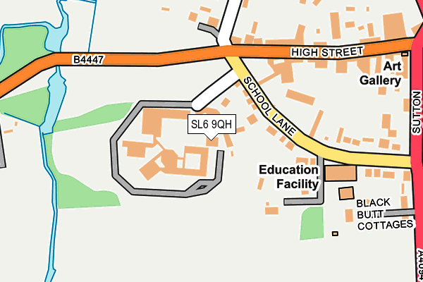
SL6 9QH is located in the Bisham & Cookham electoral ward, within the unitary authority of Windsor and Maidenhead and the English Parliamentary constituency of Maidenhead. The Sub Integrated Care Board (ICB) Location is NHS Frimley ICB - D4U1Y and the police force is Thames Valley. This postcode has been in use since January 1980.


GetTheData
Source: OS OpenMap – Local (Ordnance Survey)
Source: OS VectorMap District (Ordnance Survey)
Licence: Open Government Licence (requires attribution)
| Easting | 489429 |
| Northing | 185211 |
| Latitude | 51.558705 |
| Longitude | -0.711365 |
GetTheData
Source: Open Postcode Geo
Licence: Open Government Licence
| Country | England |
| Postcode District | SL6 |
➜ See where SL6 is on a map ➜ Where is Cookham? | |
GetTheData
Source: Land Registry Price Paid Data
Licence: Open Government Licence
Elevation or altitude of SL6 9QH as distance above sea level:
| Metres | Feet | |
|---|---|---|
| Elevation | 30m | 98ft |
Elevation is measured from the approximate centre of the postcode, to the nearest point on an OS contour line from OS Terrain 50, which has contour spacing of ten vertical metres.
➜ How high above sea level am I? Find the elevation of your current position using your device's GPS.
GetTheData
Source: Open Postcode Elevation
Licence: Open Government Licence
| Ward | Bisham & Cookham |
| Constituency | Maidenhead |
GetTheData
Source: ONS Postcode Database
Licence: Open Government Licence
| Cookham Village Memorial (High Street) | Cookham | 131m |
| Cookham Village Memorial (High Street Cookham) | Cookham | 139m |
| Cedar Drive (Maidenhead Road) | Cookham Rise | 557m |
| Cedar Drive (Maidenhead Road) | Cookham Rise | 563m |
| Cookham Rise Railway Station (Station Hill) | Cookham Rise | 648m |
| Cookham Station | 0.8km |
| Bourne End Station | 2km |
| Furze Platt Station | 3.1km |
GetTheData
Source: NaPTAN
Licence: Open Government Licence
GetTheData
Source: ONS Postcode Database
Licence: Open Government Licence


➜ Get more ratings from the Food Standards Agency
GetTheData
Source: Food Standards Agency
Licence: FSA terms & conditions
| Last Collection | |||
|---|---|---|---|
| Location | Mon-Fri | Sat | Distance |
| High Street Cookham | 17:30 | 10:00 | 202m |
| Station Road Cookham | 16:30 | 09:00 | 617m |
| Westwood Green | 16:30 | 09:00 | 641m |
GetTheData
Source: Dracos
Licence: Creative Commons Attribution-ShareAlike
| Risk of SL6 9QH flooding from rivers and sea | Low |
| ➜ SL6 9QH flood map | |
GetTheData
Source: Open Flood Risk by Postcode
Licence: Open Government Licence
The below table lists the International Territorial Level (ITL) codes (formerly Nomenclature of Territorial Units for Statistics (NUTS) codes) and Local Administrative Units (LAU) codes for SL6 9QH:
| ITL 1 Code | Name |
|---|---|
| TLJ | South East (England) |
| ITL 2 Code | Name |
| TLJ1 | Berkshire, Buckinghamshire and Oxfordshire |
| ITL 3 Code | Name |
| TLJ11 | Berkshire |
| LAU 1 Code | Name |
| E06000040 | Windsor and Maidenhead |
GetTheData
Source: ONS Postcode Directory
Licence: Open Government Licence
The below table lists the Census Output Area (OA), Lower Layer Super Output Area (LSOA), and Middle Layer Super Output Area (MSOA) for SL6 9QH:
| Code | Name | |
|---|---|---|
| OA | E00083474 | |
| LSOA | E01016532 | Windsor and Maidenhead 002C |
| MSOA | E02003422 | Windsor and Maidenhead 002 |
GetTheData
Source: ONS Postcode Directory
Licence: Open Government Licence
| SL6 9QQ | The Moor | 57m |
| SL6 9QL | School Lane | 81m |
| SL6 9QJ | School Lane | 128m |
| SL6 9SG | Southlands Cottages | 154m |
| SL6 9QN | School Lane | 155m |
| SL6 9SL | High Street | 169m |
| SL6 9SF | High Street | 171m |
| SL6 9SB | The Moor | 177m |
| SL6 9RE | Black Butts Cottages | 242m |
| SL6 9SJ | High Street | 244m |
GetTheData
Source: Open Postcode Geo; Land Registry Price Paid Data
Licence: Open Government Licence