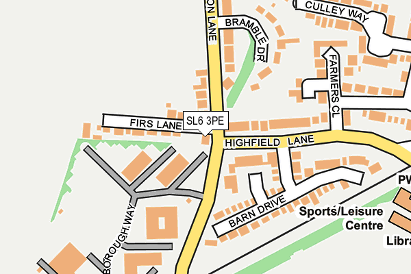
SL6 3PE lies on Cannon Lane in Maidenhead. SL6 3PE is located in the Cox Green electoral ward, within the unitary authority of Windsor and Maidenhead and the English Parliamentary constituency of Maidenhead. The Sub Integrated Care Board (ICB) Location is NHS Frimley ICB - D4U1Y and the police force is Thames Valley. This postcode has been in use since January 1980.


GetTheData
Source: OS OpenMap – Local (Ordnance Survey)
Source: OS VectorMap District (Ordnance Survey)
Licence: Open Government Licence (requires attribution)
| Easting | 485983 |
| Northing | 179702 |
| Latitude | 51.509715 |
| Longitude | -0.762423 |
GetTheData
Source: Open Postcode Geo
Licence: Open Government Licence
| Street | Cannon Lane |
| Town/City | Maidenhead |
| Country | England |
| Postcode District | SL6 |
| ➜ SL6 open data dashboard ➜ See where SL6 is on a map ➜ Where is Maidenhead? | |
GetTheData
Source: Land Registry Price Paid Data
Licence: Open Government Licence
Elevation or altitude of SL6 3PE as distance above sea level:
| Metres | Feet | |
|---|---|---|
| Elevation | 40m | 131ft |
Elevation is measured from the approximate centre of the postcode, to the nearest point on an OS contour line from OS Terrain 50, which has contour spacing of ten vertical metres.
➜ How high above sea level am I? Find the elevation of your current position using your device's GPS.
GetTheData
Source: Open Postcode Elevation
Licence: Open Government Licence
| Ward | Cox Green |
| Constituency | Maidenhead |
GetTheData
Source: ONS Postcode Database
Licence: Open Government Licence
THE THATCHED COTTAGE, CANNON LANE, MAIDENHEAD, SL6 3PE 2007 17 DEC £443,708 |
GetTheData
Source: HM Land Registry Price Paid Data
Licence: Contains HM Land Registry data © Crown copyright and database right 2024. This data is licensed under the Open Government Licence v3.0.
| December 2023 | Violence and sexual offences | On or near Bissley Drive | 440m |
| August 2023 | Violence and sexual offences | On or near Bissley Drive | 440m |
| August 2023 | Violence and sexual offences | On or near Bissley Drive | 440m |
| ➜ Get more crime data in our Crime section | |||
GetTheData
Source: data.police.uk
Licence: Open Government Licence
| Thatched Cottage (Cannon Lane) | Woodlands Park | 67m |
| Thatched Cottage (Cannon Lane) | Woodlands Park | 76m |
| Highfield Lane | Maidenhead | 137m |
| Highfield Lane | Maidenhead | 161m |
| Farmers Way | Maidenhead | 322m |
| Maidenhead Station | 2.9km |
| Furze Platt Station | 3.5km |
GetTheData
Source: NaPTAN
Licence: Open Government Licence
GetTheData
Source: ONS Postcode Database
Licence: Open Government Licence


➜ Get more ratings from the Food Standards Agency
GetTheData
Source: Food Standards Agency
Licence: FSA terms & conditions
| Last Collection | |||
|---|---|---|---|
| Location | Mon-Fri | Sat | Distance |
| Altwood Road | 17:30 | 12:00 | 670m |
| Wessex Way | 17:00 | 11:45 | 675m |
| Lowbrooke Drive | 17:00 | 11:30 | 696m |
GetTheData
Source: Dracos
Licence: Creative Commons Attribution-ShareAlike
| Facility | Distance |
|---|---|
| Cox Green Leisure Centre Highfield Lane, Maidenhead Health and Fitness Gym, Artificial Grass Pitch, Grass Pitches, Sports Hall, Studio, Indoor Tennis Centre | 330m |
| Lowbrook Academy Fairlea, Maidenhead Grass Pitches | 537m |
| Claires Court Junior Boys The Thicket, Maidenhead Sports Hall, Swimming Pool, Grass Pitches | 709m |
GetTheData
Source: Active Places
Licence: Open Government Licence
| School | Phase of Education | Distance |
|---|---|---|
| Manor Green School Elizabeth Hawkes Way, Windsor & Maidenhead, Maidenhead, SL6 3EQ | Not applicable | 282m |
| Cox Green School Highfield Lane, Maidenhead, SL6 3AX | Secondary | 416m |
| Lowbrook Academy The Fairway, Cox Green, Maidenhead, SL6 3AR | Primary | 646m |
GetTheData
Source: Edubase
Licence: Open Government Licence
The below table lists the International Territorial Level (ITL) codes (formerly Nomenclature of Territorial Units for Statistics (NUTS) codes) and Local Administrative Units (LAU) codes for SL6 3PE:
| ITL 1 Code | Name |
|---|---|
| TLJ | South East (England) |
| ITL 2 Code | Name |
| TLJ1 | Berkshire, Buckinghamshire and Oxfordshire |
| ITL 3 Code | Name |
| TLJ11 | Berkshire |
| LAU 1 Code | Name |
| E06000040 | Windsor and Maidenhead |
GetTheData
Source: ONS Postcode Directory
Licence: Open Government Licence
The below table lists the Census Output Area (OA), Lower Layer Super Output Area (LSOA), and Middle Layer Super Output Area (MSOA) for SL6 3PE:
| Code | Name | |
|---|---|---|
| OA | E00083621 | |
| LSOA | E01016561 | Windsor and Maidenhead 008C |
| MSOA | E02003428 | Windsor and Maidenhead 008 |
GetTheData
Source: ONS Postcode Directory
Licence: Open Government Licence
| SL6 3PQ | Cannon Lane | 60m |
| SL6 3PF | Highfield Lane | 99m |
| SL6 3PG | Firs Lane | 103m |
| SL6 3PR | Barn Drive | 133m |
| SL6 3NX | Bramble Drive | 174m |
| SL6 3PZ | Farmers Close | 198m |
| SL6 3PH | Cannon Lane | 210m |
| SL6 3PU | Farmers Way | 243m |
| SL6 3PN | Copthorn Close | 260m |
| SL6 3PX | Culley Way | 270m |
GetTheData
Source: Open Postcode Geo; Land Registry Price Paid Data
Licence: Open Government Licence