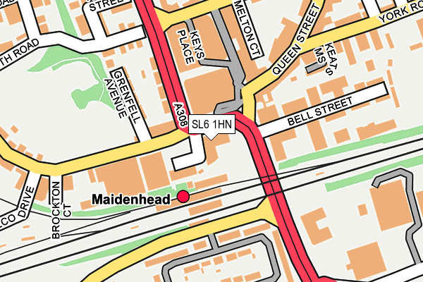
SL6 1HN is located in the St Mary's electoral ward, within the unitary authority of Windsor and Maidenhead and the English Parliamentary constituency of Maidenhead. The Sub Integrated Care Board (ICB) Location is NHS Frimley ICB - D4U1Y and the police force is Thames Valley. This postcode has been in use since December 1998.


GetTheData
Source: OS OpenMap – Local (Ordnance Survey)
Source: OS VectorMap District (Ordnance Survey)
Licence: Open Government Licence (requires attribution)
| Easting | 488734 |
| Northing | 180806 |
| Latitude | 51.519214 |
| Longitude | -0.722515 |
GetTheData
Source: Open Postcode Geo
Licence: Open Government Licence
| Country | England |
| Postcode District | SL6 |
| ➜ SL6 open data dashboard ➜ See where SL6 is on a map ➜ Where is Maidenhead? | |
GetTheData
Source: Land Registry Price Paid Data
Licence: Open Government Licence
Elevation or altitude of SL6 1HN as distance above sea level:
| Metres | Feet | |
|---|---|---|
| Elevation | 30m | 98ft |
Elevation is measured from the approximate centre of the postcode, to the nearest point on an OS contour line from OS Terrain 50, which has contour spacing of ten vertical metres.
➜ How high above sea level am I? Find the elevation of your current position using your device's GPS.
GetTheData
Source: Open Postcode Elevation
Licence: Open Government Licence
| Ward | St Mary's |
| Constituency | Maidenhead |
GetTheData
Source: ONS Postcode Database
Licence: Open Government Licence
| December 2023 | Other theft | On or near Queen Street | 284m |
| December 2023 | Violence and sexual offences | On or near Queen Street | 284m |
| November 2023 | Violence and sexual offences | On or near Queen Street | 284m |
| ➜ Get more crime data in our Crime section | |||
GetTheData
Source: data.police.uk
Licence: Open Government Licence
| Grenfell Place (Grenfell Road) | Maidenhead Town Centre | 13m |
| Grenfell Place (Grenfell Road) | Maidenhead Town Centre | 107m |
| Maidenhead Railway Station (Shoppenhangers Road) | Maidenhead Town Centre | 114m |
| Railway Bridge (King Street) | Maidenhead Town Centre | 115m |
| Maidenhead Railway Station (Shoppenhangers Road) | Maidenhead Town Centre | 123m |
| Maidenhead Station | 0.1km |
| Furze Platt Station | 1.6km |
| Taplow Station | 2.9km |
GetTheData
Source: NaPTAN
Licence: Open Government Licence
GetTheData
Source: ONS Postcode Database
Licence: Open Government Licence


➜ Get more ratings from the Food Standards Agency
GetTheData
Source: Food Standards Agency
Licence: FSA terms & conditions
| Last Collection | |||
|---|---|---|---|
| Location | Mon-Fri | Sat | Distance |
| Station Approach | 16:15 | 11:30 | 50m |
| King Street | 17:30 | 11:45 | 135m |
| Queen Street | 17:00 | 12:00 | 168m |
GetTheData
Source: Dracos
Licence: Creative Commons Attribution-ShareAlike
| Facility | Distance |
|---|---|
| David Lloyd (Maidenhead) Grenfell Place, Grenfell Island, Maidenhead Swimming Pool, Health and Fitness Gym, Studio | 117m |
| York Road (Maidenhead United Fc) York Road, Maidenhead Grass Pitches, Artificial Grass Pitch | 323m |
| Puregym (Maidenhead) Stafferton Way, Maidenhead Health and Fitness Gym | 328m |
GetTheData
Source: Active Places
Licence: Open Government Licence
| School | Phase of Education | Distance |
|---|---|---|
| Desborough College Shoppenhangers Road, Maidenhead, SL6 2QB | Secondary | 492m |
| Highfield Preparatory School Limited 2 West Road, Maidenhead, SL6 1PD | Not applicable | 507m |
| RBWM Alternative Learning Provision Town Hall, St Ives Road, Maidenhead, SL6 8BY | Not applicable | 858m |
GetTheData
Source: Edubase
Licence: Open Government Licence
The below table lists the International Territorial Level (ITL) codes (formerly Nomenclature of Territorial Units for Statistics (NUTS) codes) and Local Administrative Units (LAU) codes for SL6 1HN:
| ITL 1 Code | Name |
|---|---|
| TLJ | South East (England) |
| ITL 2 Code | Name |
| TLJ1 | Berkshire, Buckinghamshire and Oxfordshire |
| ITL 3 Code | Name |
| TLJ11 | Berkshire |
| LAU 1 Code | Name |
| E06000040 | Windsor and Maidenhead |
GetTheData
Source: ONS Postcode Directory
Licence: Open Government Licence
The below table lists the Census Output Area (OA), Lower Layer Super Output Area (LSOA), and Middle Layer Super Output Area (MSOA) for SL6 1HN:
| Code | Name | |
|---|---|---|
| OA | E00083491 | |
| LSOA | E01016536 | Windsor and Maidenhead 005D |
| MSOA | E02003425 | Windsor and Maidenhead 005 |
GetTheData
Source: ONS Postcode Directory
Licence: Open Government Licence
| SL6 1HH | Grenfell Road | 75m |
| SL6 1HJ | Grenfell Place | 116m |
| SL6 1HQ | Grenfell Avenue | 129m |
| SL6 1HT | Queen Street | 141m |
| SL6 1FG | Grenfell Road | 143m |
| SL6 1LR | Queen Street | 149m |
| SL6 1ES | Grenfell Road | 161m |
| SL6 2PS | Courtlands | 164m |
| SL6 2PU | Courtlands | 166m |
| SL6 2PT | Courtlands | 167m |
GetTheData
Source: Open Postcode Geo; Land Registry Price Paid Data
Licence: Open Government Licence