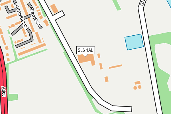
SL6 1AL is located in the Oldfield electoral ward, within the unitary authority of Windsor and Maidenhead and the English Parliamentary constituency of Maidenhead. The Sub Integrated Care Board (ICB) Location is NHS Frimley ICB - D4U1Y and the police force is Thames Valley. This postcode has been in use since October 2016.


GetTheData
Source: OS OpenMap – Local (Ordnance Survey)
Source: OS VectorMap District (Ordnance Survey)
Licence: Open Government Licence (requires attribution)
| Easting | 489318 |
| Northing | 180244 |
| Latitude | 51.514073 |
| Longitude | -0.714225 |
GetTheData
Source: Open Postcode Geo
Licence: Open Government Licence
| Country | England |
| Postcode District | SL6 |
➜ See where SL6 is on a map ➜ Where is Maidenhead? | |
GetTheData
Source: Land Registry Price Paid Data
Licence: Open Government Licence
Elevation or altitude of SL6 1AL as distance above sea level:
| Metres | Feet | |
|---|---|---|
| Elevation | 30m | 98ft |
Elevation is measured from the approximate centre of the postcode, to the nearest point on an OS contour line from OS Terrain 50, which has contour spacing of ten vertical metres.
➜ How high above sea level am I? Find the elevation of your current position using your device's GPS.
GetTheData
Source: Open Postcode Elevation
Licence: Open Government Licence
| Ward | Oldfield |
| Constituency | Maidenhead |
GetTheData
Source: ONS Postcode Database
Licence: Open Government Licence
| Sports Centre (Braywick Road) | Bray Wick | 365m |
| Stafferton Way | Maidenhead | 454m |
| Chiltern Road (Bray Road) | Maidenhead | 461m |
| Stafferton Way | Maidenhead | 468m |
| Chiltern Road (Bray Road) | Maidenhead | 504m |
| Maidenhead Station | 0.8km |
| Furze Platt Station | 2.3km |
| Taplow Station | 2.5km |
GetTheData
Source: NaPTAN
Licence: Open Government Licence
GetTheData
Source: ONS Postcode Database
Licence: Open Government Licence


➜ Get more ratings from the Food Standards Agency
GetTheData
Source: Food Standards Agency
Licence: FSA terms & conditions
| Last Collection | |||
|---|---|---|---|
| Location | Mon-Fri | Sat | Distance |
| Avenue Road | 16:45 | 11:30 | 477m |
| Braywick Road | 17:30 | 11:30 | 498m |
| Maidenhead Delivery Office | 18:30 | 12:30 | 523m |
GetTheData
Source: Dracos
Licence: Creative Commons Attribution-ShareAlike
| Risk of SL6 1AL flooding from rivers and sea | Very Low |
| ➜ SL6 1AL flood map | |
GetTheData
Source: Open Flood Risk by Postcode
Licence: Open Government Licence
The below table lists the International Territorial Level (ITL) codes (formerly Nomenclature of Territorial Units for Statistics (NUTS) codes) and Local Administrative Units (LAU) codes for SL6 1AL:
| ITL 1 Code | Name |
|---|---|
| TLJ | South East (England) |
| ITL 2 Code | Name |
| TLJ1 | Berkshire, Buckinghamshire and Oxfordshire |
| ITL 3 Code | Name |
| TLJ11 | Berkshire |
| LAU 1 Code | Name |
| E06000040 | Windsor and Maidenhead |
GetTheData
Source: ONS Postcode Directory
Licence: Open Government Licence
The below table lists the Census Output Area (OA), Lower Layer Super Output Area (LSOA), and Middle Layer Super Output Area (MSOA) for SL6 1AL:
| Code | Name | |
|---|---|---|
| OA | E00083759 | |
| LSOA | E01016591 | Windsor and Maidenhead 004D |
| MSOA | E02003424 | Windsor and Maidenhead 004 |
GetTheData
Source: ONS Postcode Directory
Licence: Open Government Licence
| SL6 1BB | Greenfields | 302m |
| SL6 1BN | Braywick Road | 370m |
| SL6 1DA | Braywick Road | 399m |
| SL6 1BD | Greenfields | 399m |
| SL6 1XN | Chalgrove Close | 405m |
| SL6 1DE | Braywick Road | 418m |
| SL6 1BA | Greenfields | 424m |
| SL6 1XZ | Green Lane | 458m |
| SL6 1UF | Bray Road | 479m |
| SL6 1UE | Bray Road | 483m |
GetTheData
Source: Open Postcode Geo; Land Registry Price Paid Data
Licence: Open Government Licence