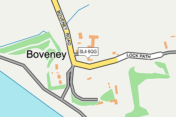
SL4 6QG lies on Boveney Road in Dorney, Windsor. SL4 6QG is located in the Cliveden electoral ward, within the unitary authority of Buckinghamshire and the English Parliamentary constituency of Beaconsfield. The Sub Integrated Care Board (ICB) Location is NHS Buckinghamshire, Oxfordshire and Berkshire West ICB - 14Y and the police force is Thames Valley. This postcode has been in use since January 1980.


GetTheData
Source: OS OpenMap – Local (Ordnance Survey)
Source: OS VectorMap District (Ordnance Survey)
Licence: Open Government Licence (requires attribution)
| Easting | 493683 |
| Northing | 177784 |
| Latitude | 51.491253 |
| Longitude | -0.651993 |
GetTheData
Source: Open Postcode Geo
Licence: Open Government Licence
| Street | Boveney Road |
| Locality | Dorney |
| Town/City | Windsor |
| Country | England |
| Postcode District | SL4 |
➜ See where SL4 is on a map ➜ Where is Boveney? | |
GetTheData
Source: Land Registry Price Paid Data
Licence: Open Government Licence
Elevation or altitude of SL4 6QG as distance above sea level:
| Metres | Feet | |
|---|---|---|
| Elevation | 20m | 66ft |
Elevation is measured from the approximate centre of the postcode, to the nearest point on an OS contour line from OS Terrain 50, which has contour spacing of ten vertical metres.
➜ How high above sea level am I? Find the elevation of your current position using your device's GPS.
GetTheData
Source: Open Postcode Elevation
Licence: Open Government Licence
| Ward | Cliveden |
| Constituency | Beaconsfield |
GetTheData
Source: ONS Postcode Database
Licence: Open Government Licence
| Ruddlesway Roundabout (Ruddlesway) | Dedworth | 853m |
| Ballard Green (Aston Mead) | Dedworth | 853m |
| Ballard Green (Aston Mead) | Dedworth | 858m |
| Cawcott Drive (Aston Mead) | Dedworth | 938m |
| Withey Close (Gallys Road) | Dedworth | 967m |
| Windsor & Eton Central Station | 3km |
| Windsor & Eton Riverside Station | 3.2km |
| Burnham (Berks) Station | 3.6km |
GetTheData
Source: NaPTAN
Licence: Open Government Licence
| Percentage of properties with Next Generation Access | 100.0% |
| Percentage of properties with Superfast Broadband | 0.0% |
| Percentage of properties with Ultrafast Broadband | 0.0% |
| Percentage of properties with Full Fibre Broadband | 0.0% |
Superfast Broadband is between 30Mbps and 300Mbps
Ultrafast Broadband is > 300Mbps
| Percentage of properties unable to receive 2Mbps | 0.0% |
| Percentage of properties unable to receive 5Mbps | 0.0% |
| Percentage of properties unable to receive 10Mbps | 0.0% |
| Percentage of properties unable to receive 30Mbps | 100.0% |
GetTheData
Source: Ofcom
Licence: Ofcom Terms of Use (requires attribution)
GetTheData
Source: ONS Postcode Database
Licence: Open Government Licence


➜ Get more ratings from the Food Standards Agency
GetTheData
Source: Food Standards Agency
Licence: FSA terms & conditions
| Last Collection | |||
|---|---|---|---|
| Location | Mon-Fri | Sat | Distance |
| Lake End Road Dorney | 16:30 | 07:45 | 1,994m |
| Hatch Lane | 17:30 | 11:45 | 2,190m |
| Hunters Lane | 18:30 | 10:45 | 2,217m |
GetTheData
Source: Dracos
Licence: Creative Commons Attribution-ShareAlike
| Risk of SL4 6QG flooding from rivers and sea | Medium |
| ➜ SL4 6QG flood map | |
GetTheData
Source: Open Flood Risk by Postcode
Licence: Open Government Licence
The below table lists the International Territorial Level (ITL) codes (formerly Nomenclature of Territorial Units for Statistics (NUTS) codes) and Local Administrative Units (LAU) codes for SL4 6QG:
| ITL 1 Code | Name |
|---|---|
| TLJ | South East (England) |
| ITL 2 Code | Name |
| TLJ1 | Berkshire, Buckinghamshire and Oxfordshire |
| ITL 3 Code | Name |
| TLJ13 | Buckinghamshire |
| LAU 1 Code | Name |
| E06000060 | Buckinghamshire |
GetTheData
Source: ONS Postcode Directory
Licence: Open Government Licence
The below table lists the Census Output Area (OA), Lower Layer Super Output Area (LSOA), and Middle Layer Super Output Area (MSOA) for SL4 6QG:
| Code | Name | |
|---|---|---|
| OA | E00089887 | |
| LSOA | E01017814 | South Bucks 006C |
| MSOA | E02003693 | South Bucks 006 |
GetTheData
Source: ONS Postcode Directory
Licence: Open Government Licence
| SL4 6QE | Boveney Road | 110m |
| SL4 6QF | Boveney Road | 116m |
| SL4 6QQ | Lock Path | 270m |
| SL4 5TH | River Road | 628m |
| SL4 6QD | Boveney Road | 646m |
| SL4 5TN | Maidenhead Road | 690m |
| SL4 5TP | The Willows | 710m |
| SL4 5TW | Maidenhead Road | 716m |
| SL4 5TR | Maidenhead Road | 729m |
| SL4 5UA | The Willows | 760m |
GetTheData
Source: Open Postcode Geo; Land Registry Price Paid Data
Licence: Open Government Licence